

A taste of summer for NJ Thursday: Warm 80s, then strong thunderstorms
The Bottom Line
Thursday will be a day of transition for New Jersey. From ridiculous, summerlike warmth to potentially potent thunderstorms. I am becoming increasingly concerned that gusty winds and heavy rain will coincide with Thursday evening's rush hour.
Behind the front, we look ahead to the Good Friday-Passover-Easter holiday weekend. Friday looks fine. Saturday will be partially wet. And Sunday could be surprisingly cool.
Thursday
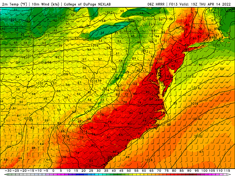
The hot spot in New Jersey on Wednesday was an impressive 86 degrees at Sicklerville in Camden County — it hasn't been that warm since mid-September. I'm not sure we'll break that number on Thursday, but more 80s are on the way.
Stepping outside Thursday morning, you can already tell it's going to be a warm day. It is a mild start to the day, with temperatures mainly in the 60s. There are a few pockets of 50s, to the northwest and along the coast. And even a few 70s along the I-295 corridor. By the numbers, it is similar to a typical June or September morning — not mid-April.
Highs will push toward 80 degrees for most of the state by midday Thursday. Even mainland beaches will be nice and toasty warm, with a stiff southwestly breeze up to 20 mph. (Compared to yesterday's southeasterly on-shore breeze.) Barrier islands will end up cooler, no matter what.
We'll see lots of sun early on, then building clouds by the afternoon.
Starting around 3 or 4 p.m., we'll have to watch the western sky as a cold front drives in a line of thunderstorms.

Given how juicy the atmosphere will be, parameters are pointing toward some gusty winds and pockets of heavy rain. If I had to guess where the greatest severe weather potential would be, I'd say along and just south of the Interstate 78 corridor. Right through the heart of NJ.
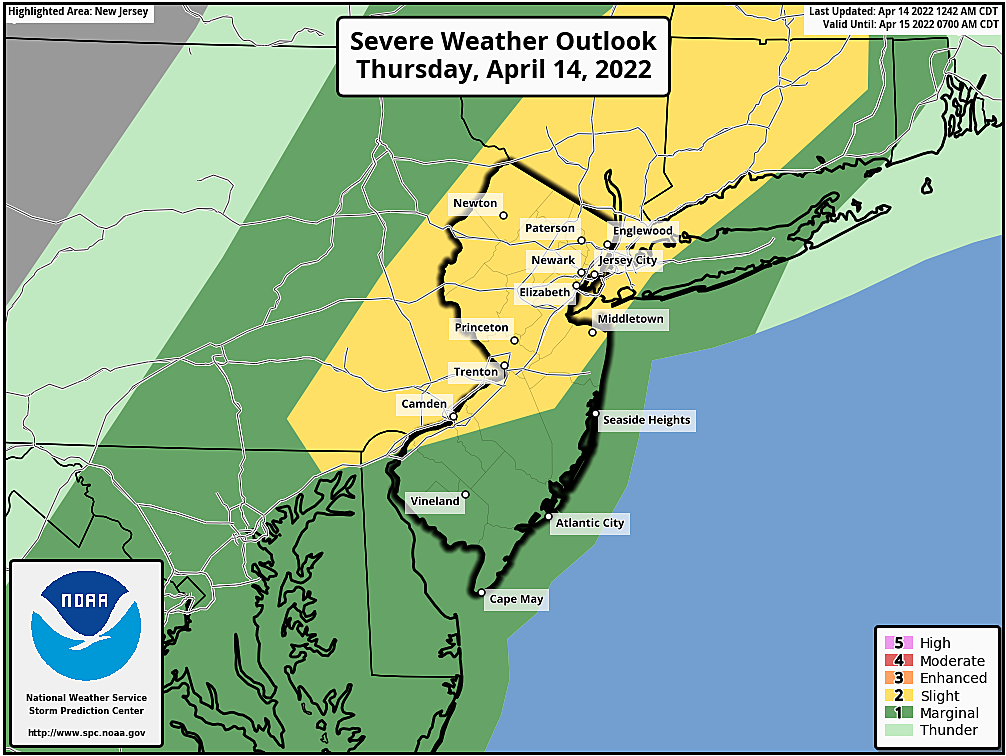
The timing is unfortunate and extra concerning, as the nastiest weather coincides with the evening rush hour.
By about 8 p.m., storms should fizzle and/or exit the coast. Showers may linger through the evening hours (as late as Midnight), especially around southern New Jersey.
Behind the rain, both temperatures and dew points will start to tumble. I'm not sure we can call it "cold" overnight. But definitely "cool" — look for lows in the mid 40s.
Friday
Cooler. But still pleasant.
Friday should be a nice, bright day with mostly sunny skies resuming by mid-morning. It will be breezy too, up to 20 mph.
High temperatures will reach the mid 60s. Yes, that is a full 15 degrees cooler than Wednesday and Thursday. But it's still above normal for mid-April. So again, I think it's still fair to call it a nice day overall.
Saturday
Not as nice.
Clouds will take over Saturday morning. And as another cold front approaches, we are going to see some wet weather eventually.
Model guidance puts a few spotty showers over New Jersey Saturday afternoon. But I think the best chance for scattered rain will be Saturday afternoon and evening. This time, we're lacking any real "oomph" in the atmosphere, so big bad thunderstorms and severe weather are highly unlikely. Just unsettled skies and some raindrops.
Another cooldown will prevail Saturday night. Temperatures could dip into the 30s by Sunday morning, cold enough for a frost or even a freeze. (Especially for the northern half of the state.)
Sunday
High temperatures for Easter Sunday are only forecast to reach the lower 50s. A full 30-degree difference from the Wednesday-Thursday warmth! It will be breezy too, so you'll have to pair your Easter bonnet with a jacket.
But at least Sunday is trending mostly sunny and dry.
The Extended Forecast
Monday also looks relatively cool, in the 50s, with spotty showers possible. We should warm back to 60+ degrees by midweek. Having said that, I do not foresee a return to 70s or 80s for quite a while. In fact, if long-range outlooks hold true, we may not hit 70+ again until May.
Dan Zarrow is Chief Meteorologist for Townsquare Media New Jersey. Follow him on Facebook or Twitter for the latest forecast and realtime weather updates.
Cough, cough: NJ's favorite lost voice and sore throat remedies
Gallery Credit: Dan Zarrow
The many reasons why we're so happy living in New Jersey
Gallery Credit: Steve Trevelise
More From New Jersey 101.5 FM


