
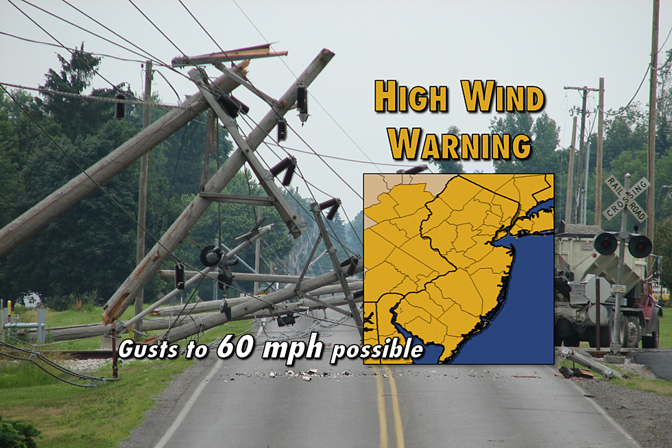
7 things to know about this weekend’s wicked winds in NJ
A High Wind Warning is in effect for the entire Garden State from late Saturday night through Sunday.
BOTTOM LINE
A strong pressure gradient (the difference between an area of very high pressure and an area of very low pressure) will set up over New Jersey from late Saturday night through the day Sunday. This will result in a powerful west-northwest wind, sustained at 25 to 35 mph with gusts to 60 mph.
It's important to realize this isn't your typical breezy or windy day. Gale force winds and tropical storm force gusts are serious business.
HIGH WIND WARNING

New Jersey doesn't fall under a High Wind Warning often. But when one is issued, it is very important to pay attention. These winds aren't just gusty - they're potentially damaging and potentially dangerous.
According to the National Weather Service, a High Wind Warning means "a hazardous high wind event is expected." In this case, severe wind gusts over 58 mph (60 knots) may cause property damage.
A High Wind Warning will be in effect from Midnight to Noon Sunday for the following counties in New Jersey: Atlantic, Burlington, Camden, Cape May, Cumberland, Gloucester, Hunterdon, Mercer, Middlesex, Monmouth, Morris, Ocean, Salem, Somerset, Sussex, Warren.
A High Wind Warning will be in effect from Midnight to 2 p.m. Sunday for the following counties in New Jersey: Bergen, Essex, Hudson, Passaic, and Union.
Despite the slight difference in expiration time, both warnings indicate impressive wind gusts of 60 mph will be possible. All 21 counties in New Jersey fall under a High Wind Warning for at least 12 hours on Sunday.
TIMING
During the day Saturday, winds will be manageable - sustained at 10 to 20 mph, with occasional gusts to 25 or 30 mph.
Around midnight Saturday night/Sunday morning, wind speeds will increase dramatically - sustained at 25 to 35 mph, with gusts to 50 or 60 mph.
The wind will howl through the Sunday early morning hours. If I had to pick a time for the peak gusts, I would say mid-to-late Sunday morning. But the strong winds will be fairly consistent from onset through part of the afternoon.
There will be little relief from the wind onslaught until late afternoon Sunday. Winds will slowly subside through Sunday evening.
By midnight Sunday night/Monday morning, winds should become light or even calm across New Jersey.
Monday will be breezy, but nowhere near as gusty as Sunday.
IMPACTS
High winds may cause any or all of the following:
--Downed trees and power lines, leading to scattered power outages.
--Some property damage is possible to buildings and structures, especially to roofs and gutters.
--Challenging driving conditions for high-profile vehicles, such as trucks and buses. (Particularly on north-south roads, bridges, and elevated roadways.)
--Items left outside and unsecured, such as garbage cans and patio furniture, may topple or blow away.
COASTAL FLOODING
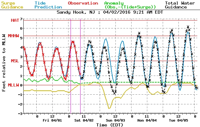
Since the powerful winds will be blowing from the west-northwest, it is a land breeze. Therefore, the Jersey Shore should not experience significant coastal flooding (as it would if this wind were coming off the ocean). In fact, tidal models indicate Sunday morning's tide cycle will be much lower than usual, as water is blown seaward.
It's still going to be important to not let our guard down. Wind-driven rough surf is likely and we may have to deal with some flooding. That will be especially true along bay shores (with western exposures).
WIND CHILLS
As if the fierce wind isn't enough, we're also expecting a significant cooldown for this first Sunday of April. Sunday morning's low temperature is forecast to end up in the mid 30s. Sunday's afternoon high temperatures will be limited to the mid 40s.
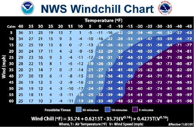
More importantly, the combination of cold and wind is never a comfortable one. The wind chill, also known as the "feels like" temperature or "apparent" temperature, is a measure of heat loss and cold-weather discomfort for humans. Our wind chill will probably be stuck in the 20s, at best, all day Sunday. That would be a cold, blustery day even by mid-winter standards!
Oh, and a few snow showers will be possible too. While models indicate up to an inch of snow accumulation is possible in the higher elevations of North Jersey, the wind will be the primary weather concern over this weekend.
BE SAFE, STAY TUNED
It's time to batten down the hatches for a wild, windy time from Saturday night to Sunday all across New Jersey. Bring in or tie down patio furniture, outdoor toys, and garbage cans. Be safe in your preparations, and I hope you have a sturdy, warm place to ride out the wind storm. Of course, stay tuned here on the web and on your radio for the latest information on power outages, road closures, damage, and more.
Dan Zarrow is Chief Meteorologist for Townsquare Media New Jersey. Follow him on Facebook or Twitter for the latest forecast and realtime weather updates.
More From New Jersey 101.5 FM


