

6 things to know about New Jersey’s next winter storm
UPDATE... This article is outdated...
For the latest storm forecast information, please refer to my newest weather blog post.
1.) The Bottom Line: Winter perspective
Winter 2024-25 has felt very busy so far. There have been nine storms that dropped at least two inches of snow/sleet somewhere in New Jersey. (Plus a few more icing events and minor snow storms.) Plus, it has been excessively cold, resulting in the state's coldest January in a decade.
However, we have very little to show for this hyperactive season. Season-to-date snowfall is running about six inches below normal for most of the state. January was New Jersey's third driest on record. Yes, we have shoveled and plowed and salted — but many are still craving some real snow before winter wraps up.
As we enter mid-February — typically one of New Jersey's snowiest periods of the entire year — we find ourselves riding a long train of storm systems. Following last Thursday's sloppy snow/ice storm and Saturday night's snow/ice storm, there are at least three more storms on the horizon.
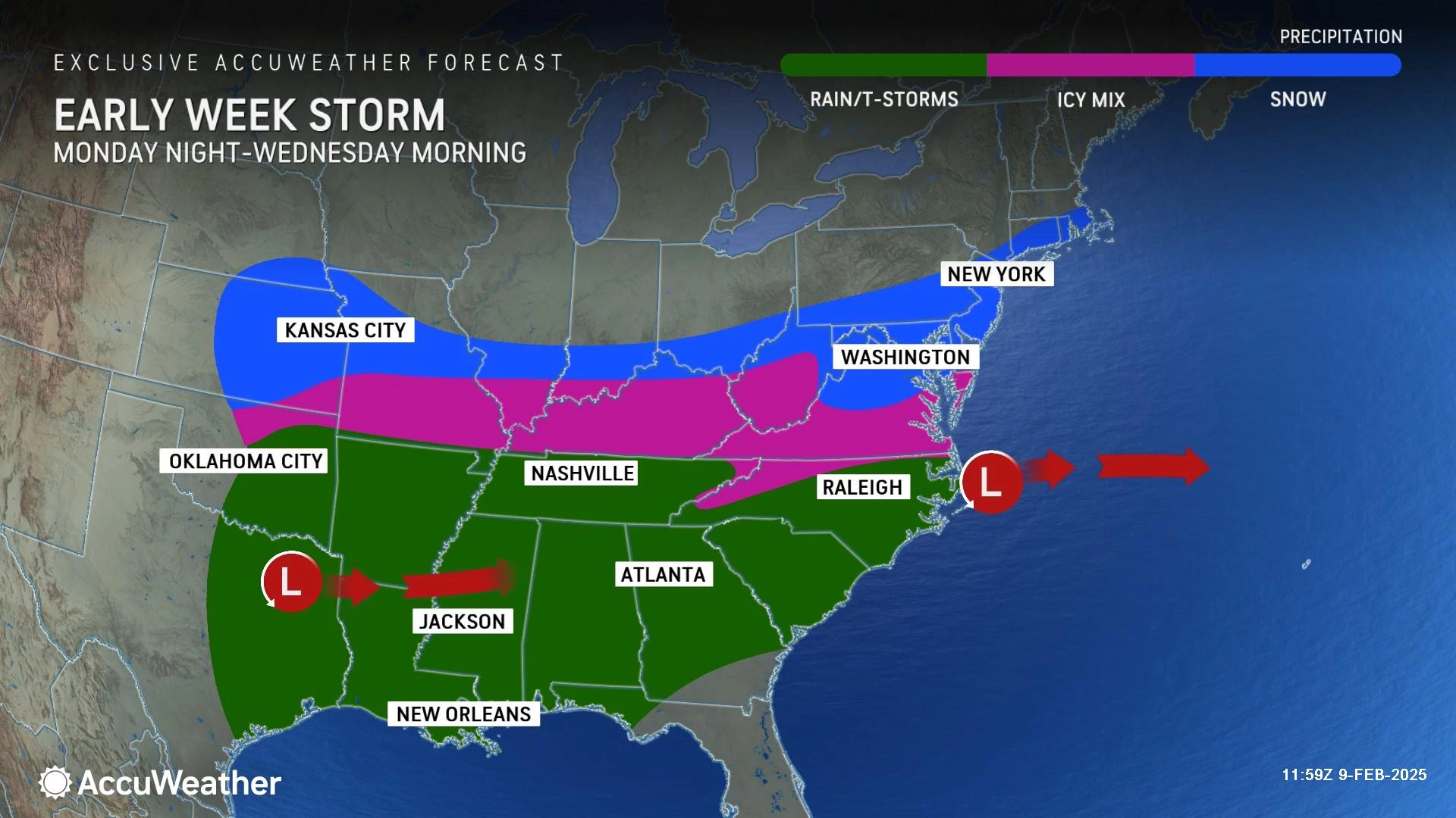
The next one on Tuesday will feature cold air. Cold enough, in fact, for an almost all-snow situation in New Jersey. And given the track of this area of low pressure pushing just south and east of New Jersey, this one looks like a "South Jersey Special".
There are a couple more opportunities for messy, inclement, wintry weather on Wednesday night to Thursday and next weekend. While I am focusing this article on the Tuesday storm, we will be watching how that forecast develops very closely too.
Buckle up — winter ain't over yet!

2.) Before the Storm: A 48-hour break
As many New Jerseyans grab the shovels once again Sunday and get ready for Super Bowl festivities Sunday night, we fall into a 48-hour period of generally quiet weather.
With partial clearing, we will pick up a brisk breeze throughout the day Sunday. Top gusts will exceed 20 mph. High temperatures will get stuck near 40 degrees — likely in the upper 30s where there is snow/sleet cover on the ground, and lower 40s where there is not.
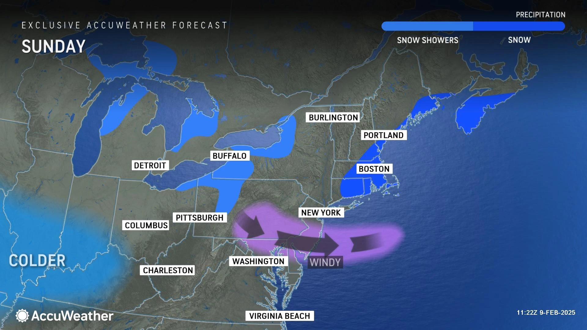
Monday will also be uneventful, but cold. A batch of showers will steer just off our southern coast. Look for partly sunny skies and highs only in the mid 30s or so. Barely above the freezing mark.
3.) Storm Timeline: Brunt Tuesday evening
Tranquil, dry weather will last through the Tuesday morning commute too.
Initial snow showers may creep into South Jersey around late Tuesday morning, filling farther north into the afternoon.
The brunt of this storm — the time of the steadiest, heaviest, and most widespread snow — looks to be from Tuesday late afternoon through Tuesday late evening. Let's say 4 p.m. to 2 a.m., just to paint a wide window. That is the worst-case scenario for any winter storm, coinciding with millions of people trying to get home from work and school.
Snow intensity will scale back early Wednesday morning, ending completely by about mid-morning. The current forecast still includes widespread wintry travel conditions through the AM commute.
4.) Accumulations / Impacts: South Jersey special
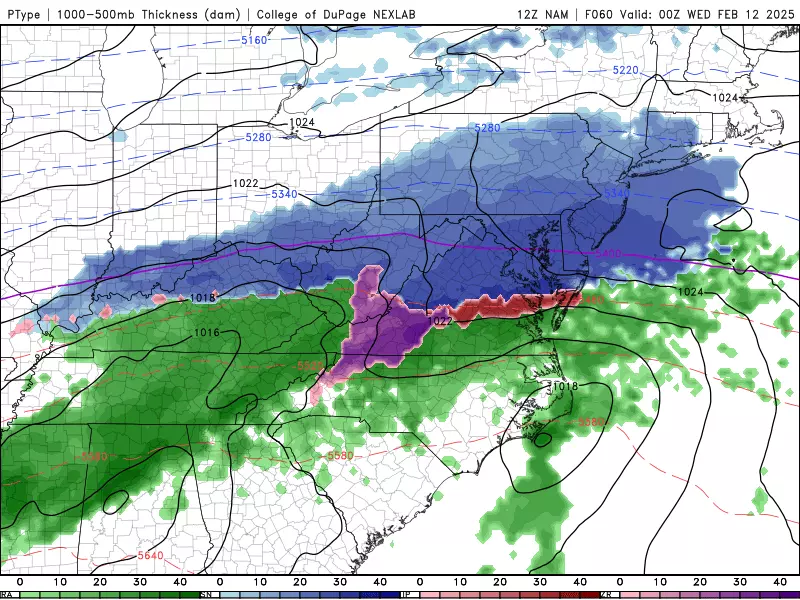
Unlike the last two times, Tuesday's storm will not carry warmer air into New Jersey's lower and mid atmosphere. Therefore, precipitation type is not a challenge this time around — we are looking at an almost all-snow situation.
However, the exact storm track will make a huge difference in who ends up in the "snow bullseye". (For more on that, see section #5 below about forecast confidence.)

Several model runs have painted Tuesday's storm to be a "South Jersey Special," with the southern third to quarter of New Jersey falling among the heaviest snowfall totals. (Potentially alongside Dover DE, Baltimore MD, and Washington DC.)
4 to 8 inches of snow in South Jersey is right on the edge of what I would consider a "major" winter storm. It is more than enough to snarl traffic and potentially keep kids home from school for a day or two.
Farther north, I have painted a wide swath of south-central New Jersey into a range of 2 to 4 inches of accumulation. Still impactful snow, but you do not need to be racing out to the grocery store for bread and milk.
North Jersey, this does not look like your storm. I am forecasting 1 to 2 inches of snow north of Interstate 78. (I was tempted to put 0 to 2 inches there, by the way.)
North of Interstate 80, little to no accumulation is expected.
There is one chance for wintry mix and or rain to get in the way of snow accumulations — the Jersey Shore. If the immediate coastline falls under the influence of an on-shore breeze and mild marine air, beach towns may end up lower than that 4-8" forecasted range. This is a possibility that we will dial in more specifically as the storm draws closer.
Since this storm system will have a coastal component to it, I also can not rule out the possibility of minor category tidal flooding too. Current storm surge guidance suggests about a foot of water rise along the Jersey Shore on Wednesday.
5.) Confidence: How things might change
The map I included here depicts a good consensus of model guidance not just from this morning, but over the last few days. That 4 to 8 inch range in South Jersey is admittedly aggressive — but I have left plenty of wiggle room to decrease or increase or get more specific as needed.
With a first call snow forecast like this, it is important to "blur your eyes" and consider how things may change as the forecast continues to evolve. I believe the margin of error for this storm is currently about 50 miles. And I have specifically drawn my map to account for such a possible upgrade or downgrade to the accumulation forecast.
For example, a 50-mile shift to the south would produce much lighter snowfall across New Jersey. (Having said that, I do not think the chance of a "total bust" is on the table — that would require a much bigger southward shift of the storm track, on the order of 100 to 150 miles). If the storm does drift away and turn less snowy, each colored region on my map would decrease by one full range category: 0" north, 0-1" north-central, 1-2" south-central, and 2-4" south.
On the other hand, a 50-mile shift to the north would introduce heavier snow right through the middle of the state. In this scenario, each colored region on my forecast map would bump up approximately one category: 1-2" north, 2-4" north-central, 4-6" south-central, and 6-10" south.
By Monday — about 24 hours before first flakes — we should nail down the potential accumulations better, in time to offer the appropriate advisories and warnings.
6.) After the Storm: Active weather continues
As this snow storm wraps up early Wednesday, our attention will then turn toward another impulse set to ride through New Jersey from late Wednesday into early Thursday. What a quick turnaround!

That one will not be an all-snow situation. In fact, it looks like a classic warming winter storm, with snow at onset, quickly changing to wintry mix and then mainly rain. I could see an additional inch of snow/sleet in addition to a light glaze of ice. Enough to raise alarm bells for sloppy travel, but not as impactful as Tuesday night's storm.

The next next next storm down the line is set to arrive this weekend, from late Saturday into Sunday. Almost a week away, models are flip-flopping between wintry and wet solutions. So I do not have much confident insight to offer at this time — it is just something else to watch.
Will things calm down after the President's Day Weekend? Long-range models say yes, at least a little bit. But I will never bang the gavel on the potential for "big" winter storms until the Spring Equinox is in sight. 39 days and counting...
Expect my next weather blog update early Monday morning.
All New Jersey connections in 2025 Super Bowl
Gallery Credit: Erin Vogt
Dan Zarrow is Chief Meteorologist for Townsquare Media New Jersey. Follow him on Facebook for the latest forecast and realtime weather updates.
New Jersey's top 10 spots for soup
Gallery Credit: Jill Croce
More From New Jersey 101.5 FM


