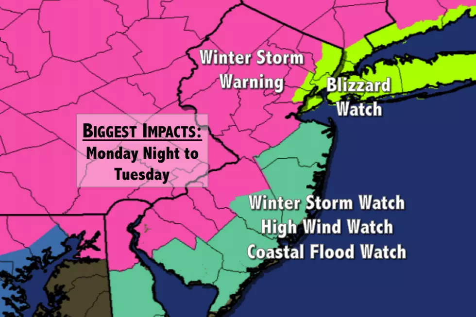
Winter Storm Warning issued ahead of Tuesday’s snow and wind
When warnings are issued, it means it's time to make critical decisions and begin seriously making storm preparations.
Even though the specific numbers on the forecast may change over the next 36 hours, serious winter weather impacts are now pretty much a sure bet throughout the warning area.
I've summarized all current watches and warnings from the National Weather Service offices in Mt. Holly, NJ and Upton, NY below. Another weather blog post containing the latest analysis and forecast for Tuesday's significant winter storm will be posted Sunday evening.
Winter Storm Warning
--From 8 p.m. Monday to 4 p.m. Tuesday for northwestern Burlington, Camden, Gloucester, and Salem counties.
--From 8 p.m. Monday to 6 p.m. Tuesday for Hunterdon, Mercer, Middlesex, Morris, Somerset, Sussex, and Warren counties.
--From Midnight Tuesday to Midnight Wednesday for western Bergen, western Essex, Passaic, and western Union counties.
A Winter Storm Warning means that heavy snow (6+ inches) and strong winds (40+ mph) will combine to make for potentially dangerous, wintry conditions. Travel will be very difficult (if not impossible) during the peak of the storm. Power outages are possible due to the weight of the snow and gusty winds.
Winter Storm Watch
--From 8 p.m. Monday to 6 p.m. Tuesday for Atlantic, southeastern Burlington, Cumberland, Monmouth, and Ocean counties.
A Winter Storm Watch serves as a "heads up" that winter weather impacts (usually 6+ inches of snow) could significantly impact travel within 24 to 48 hours. It's not a guarantee, but a pretty good bet. The Watch may be upgraded to a more urgent Winter Storm Warning or flipped to a less severe Winter Weather Advisory as the storm comes closer.
Blizzard Watch
--From Midnight Tuesday to Midnight Wednesday for eastern Bergen, eastern Essex, Hudson, and eastern Union counties.
A Blizzard Watch serves as a "heads up" that blizzard conditions are expected during the peak of the storm. By definition, a blizzard requires sustained winds or frequent gusts over 35 mph, reducing visibility due to falling or blowing snow to less than a quarter-mile for over 3 hours. If the forecast holds, this Watch may very well be upgraded to a Blizzard Warning closer to the storm's arrival.
High Wind Watch
--From 6 a.m. Tuesday to 6 p.m. Tuesday for Atlantic, southeastern Burlington, Cape May, Monmouth, and Ocean counties.
A High Wind Watch means potentially dangerous, damaging winds are possible within 24 to 48 hours. Wind gusts near 60 mph may bring down trees, branches, and power lines. As the storm approaches, this Watch will likely be upgraded to a High Wind Warning.
Coastal Flood Watch
--From 7 a.m. Tuesday to 3 p.m. Tuesday for Atlantic, southeastern Burlington, Cape May, Cumberland, Middlesex, Monmouth, and Ocean counties.
A Coastal Flood Watch means that the combination of astronomical tides and storm surge may drive water above flood stage along coastal waterways. In this case, 2 to 3 foot surge and moderate flooding are expected at the time of high tide. 12 foot ocean waves will likely cause beach erosion. If the forecast for "moderate" flooding holds, a Coastal Flood Warning will be issued just before the water begins to rise.
Dan Zarrow is Chief Meteorologist for Townsquare Media New Jersey. Follow him on Facebook or Twitter for the latest forecast and realtime weather updates.
More From New Jersey 101.5 FM


