
Wet weather returns to NJ: Over an inch of rain possible Wed-Thu
The Bottom Line
Low pressure, warm front, cold front. A period of unsettled, occasionally wet weather enters New Jersey's forecast from late Wednesday through early Friday. While parts of the Deep South have seen some intense storms with devastating tornadoes from this storm system complex, it's really just going to bring rain for New Jersey. Nothing severe, nothing wintry, and no big wind.
There are still several scenarios in play. Some models (specifically the NAM) paint a swath of 2 to 3+ inches of rain over part of the state — that's a lot, and such downpours could lead to ponding and flooding issues. On the flip side, some guidance drops as little as a half-inch to an inch of rain. The truth (and my forecast) is somewhere in the middle. Healthy rainfall, possible heavy at times.
The rain will primarily come in two pushes: the first from late Wednesday to early Thursday, and the second kicking in late Thursday.
Beyond the storm system, Friday looks good. Saturday turns cooler. Sunday and Monday could be pretty cold.
Wednesday
A noted change of pace from our recent stretch of pleasant, dry, mild weather.
As of this writing (5:30 a.m.), radar is completely clear. And temperatures are pretty chilly to start the day. We're averaging 40 degrees — that's 30s to the north, and 40s to the south.
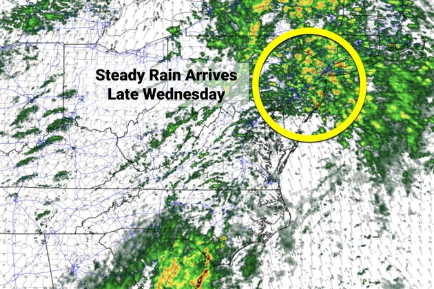
Thermometers won't go very far Wednesday, only topping out around 50 degrees. Baseline, it will be a cloudy and cool day. And we could see a few showers around — I'll even say the chance for spotty to scattered showers will increase as the day goes on.
Any threat for steadier rain should hold off until late Wednesday afternoon or (especially) Wednesday evening. That's when more widespread pockets of rain will spread throughout the state.
As a warm front lifts into New Jersey, temperatures will only fall a few degrees, into the mid 40s overnight. In fact, thermometers should start to rise by early Thursday morning, especially across the southern half of the state.
Thursday
Wet. A total washout is on the table, but it is not a guarantee for the entire state.
Again, Thursday is sandwiched in between the two main pushes of rain. So it won't be a pretty day, with steady to heavy rain at times (especially through the morning).
Also, because of the thermal boundary parked right over the state, there will be a wide temperature gradient too. Highs will only reach the mid 40s in North Jersey. But along the southern coast, we should pop into the lower 60s for most of the day.
Rainfall spread and intensity should start to wind down Thursday night, especially after Midnight.
Friday
Turning into a nice day.
There may still be a few lingering rain showers along the coast as you wake up Friday morning. But by about 8 a.m., I expect dry skies and improving weather.
We should enjoy substantial breaks of sun into Friday afternoon. It will be breezy and mild, with high temperatures near 60 degrees. So once the puddles dry up — and as long as it's not too windy — Friday looks good.
The Weekend
Cooling down.
I'll call skies "partly sunny" for both Saturday and Sunday, with bright skies amid fair weather clouds. Model guidance is hinting at a few sprinkles or showers around, especially on Saturday. But nothing to write home about. (Barely worth even mentioning here.)
Under the influence of a cooler air mass and westerly wind, high temperatures on Saturday will only reach the mid 50s or so. That's seasonable — close to normal for the final weekend of March.
Sunday will be the cooler day of the weekend, with highs only in the upper 40s. That is below normal for this time of year.
The Extended Forecast
Monday will be the bottom of the barrel of our next cold snap. Morning lows in the 20s. (Freeze alert for almost the entire state.) Afternoon highs could struggle to reach 40 degrees.
While temperatures will moderate through the middle of the week, we'll have to watch for another bout of active, stormy weather late next week. And given the presence of cold air in the neighborhood, we may have to talk about both raindrops and snowflakes from that one.
Dan Zarrow is Chief Meteorologist for Townsquare Media New Jersey. Follow him on Facebook or Twitter for the latest forecast and realtime weather updates.
New Jersey's smallest towns by population
Gallery Credit: Michael Symons
St Peters enters NCAA Sweet 16, NJ gets Peacock Fever
Gallery Credit: Associated Press
More From New Jersey 101.5 FM


