

Warm and stormy NJ: 6 things to know about Thursday’s thunderstorms
UPDATE as of 4:20 p.m. Thursday...
The National Weather Service has issued a Severe Thunderstorm Watch for 18 of New Jersey's 21 counties until Midnight. (The only counties not under the watch are Atlantic, Cape May, and Cumberland.)

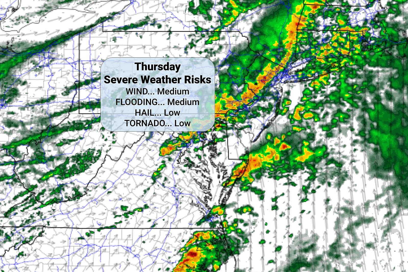
A watch is a formal heads up that dangerous, potentially damaging storms may occur. The biggest concern from Thursday evening's storms will be gusty wind. Locally heavy rainfall may also lead to flooding. The risk for a quick tornado and/or hail is low, but not zero.
It is very important for all New Jerseyans to stay alert to changing weather conditions. If a warning is issued for your area, or if a nasty storm is headed your way, you need to seek shelter inside a sturdy building until it passes.
Stay smart and be safe out there.
UPDATE as of 2 p.m. Thursday...
ORIGINAL POST from 7:33 a.m. Thursday...
1.) The Bottom Line?
New Jersey returns to springtime weather in grand fashion on Thursday. Not only does that mean temperatures will be a full 20 to 30 degrees warmer than the past four days. But it also means showers, thunderstorms, and severe weather are back in play.
The most important time of day to "watch the sky" will be in the late afternoon and evening hours. Wind is the biggest concern, with locally heavy downpours possible too. The risk of hail and a tornado are low, but not zero.
2.) How Warm?
As a warm front lifts through New Jersey Thursday morning, temperatures are already rising. As of this writing (6:45 a.m.), we are in the 40s across the northern half of the state and near 60 to the south.
High temperatures Thursday are forecast to reach about 65 to 70 degrees for the vast majority of the state. (Possible exceptions: NW NJ and the coast.) That is about 10+ degrees above normal for the final day of March.
3.) When WIll It Storm?
It looks like we'll have three primary rounds of rain affecting New Jersey throughout Thursday:
--Initial Showers... Driven by that warm front, spotty to scattered rain showers will become likely starting around 10 a.m. This initial rain should be light, and not everyone necessarily gets wet. (At the very least it will be mostly cloudy and breezy.)
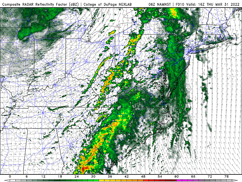
--More Numerous, More Stormy... After about 2 p.m. Thursday afternoon, the atmosphere will become warm and "juicy" enough to sustain thunderstorm development. Again, they'll be scattered, so not everyone will see a storm at this point. But any storms that do cross over the Delaware River could grow to strong (40+ mph) or severe (58+ mph) limits quickly.
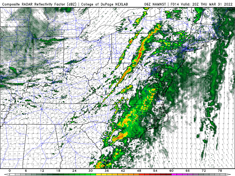
--Final Line... The grand finale round of storms, after about 7 p.m. Thursday evening, probably has the greatest severe weather potential of the day. However, those storms are "racing the clock," as intensity fizzles a bit after sunset.

By Midnight, the severe weather threat will end. We could see lingering showers through early Friday morning, until a cold front sweeps in cooler, much drier air.
4.) Biggest Concerns?
It's a classic severe weather day - although I don't think it really qualifies for "outbreak" status for NJ.

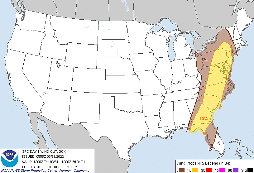
Instability and helicity will be fairly limited over New Jersey, but wind shear will be sufficient. Therefore, the following hazards will be in play, listed in decreasing order of concern:
--Damaging Winds... As I laid out above, the afternoon and evening thunderstorms could push out some strong gusts. 40+ mph seems like a sure bet at some point. And 60+ mph could down trees, cause roof damage, and turn loose items into projectiles.
--Heavy Downpours... Thursday's increase in dew points will be impressive - we're progressing from ridiculously dry air to "fairly humid" conditions. So the threat for heavy rain is present. Over an inch of rain in a short period of time could lead to flooding in low-lying and poor-drainage areas.
--Hail / Tornado... Only the strongest thunderstorms with strong updrafts and sufficient wind shear can cause hail and tornadoes. The chance is there for New Jersey, but it is low. (For the record, the risk of a quick spin-up will be greater in eastern Pennsylvania, given the timing and forecast parameters.)
--Lightning... By definition, every thunderstorm contains potentially dangerous lightning. Don't disregard the fact that you can be struck by an electrical discharge, even if a storm is miles away.
I think the concern for wind and rain extends throughout most of the Garden State, away from the coast. It looks like the best chance for a stronger hail or tornado producing storm would be in the southwest sector of NJ, generally along the I-295 corridor.
Note: Watch the sky and the thermometer today. If we get a substantial break of sun and/or temperatures spike above 70 degrees, the atmosphere is really going to cook. That will lend to higher instability - more potential energy for the late-day storms.
5.) So What?
The standard thunderstorm safety rules apply. Keep an eye and ear on the sky, and be ready to change plans accordingly as weather conditions evolve. When thunder roars, head indoors. In case of flooding, turn around, don't drown. And the safest place to be during a severe thunderstorm is on the lowest floor of a sturdy building.
6.) What's Next?
We're cooling down again on Friday. But it will not be another "arctic blast" - just a "correction to normal". In fact, highs on Friday will still be a tick above normal, near 60 degrees, before sliding backwards in the afternoon. It will be a pretty windy day, and I can't rule out a few rain showers.
Saturday looks like a splendid early Spring day. Mostly sunny, light winds, dry weather, and seasonable high temperatures in the mid 50s.
Some rain showers may impact the first part of Sunday, as a weak impulse rides through our atmosphere. And then Sunday afternoon and all of Monday look fine, with highs holding steady in the 50s.
Our next threat of a "bigger" storm system would be in the middle of next week - Tuesday and Wednesday. I could see a good inch of rain from that one, followed by another slight cooldown.
Note: The CMDZ Weather Blog will be on hiatus until next Tuesday, as I take some much-needed vacation time. We'll still post your latest 5 Day Forecast on the site daily. And you can always catch the latest weather update on the radio every 15 minutes around the clock. Be safe out there today, and I'll see ya real soon.
Dan Zarrow is Chief Meteorologist for Townsquare Media New Jersey. Follow him on Facebook or Twitter for the latest forecast and realtime weather updates.
Cape May, NJ: 15 wonderful places to visit
Gallery Credit: Erin Vogt
15 sensational places to visit in Seaside Heights and Seaside Park
Gallery Credit: Erin Vogt
More From New Jersey 101.5 FM


