

Sweltering heat and nasty thunderstorms roll into NJ Thursday
Thursday will be even hotter than Wednesday. And even stormier too. Thermometers will reach about 90 degrees Thursday afternoon, with the heat index approaching 100 degrees in spots due to high humidity. All the ingredients are coming together for strong thunderstorms late today. Prime time for storms looks to be late afternoon through the evening — let's call it 3 p.m. to 9 p.m. Gusty winds will be the #1 concern, along with torrential rain, lightning, hail, and even a tornado. Behind the storms will come slightly cooler and much drier air, setting up a beautiful weather day for Friday, the Summer Solstice. Temperatures climb again this weekend, leading to our first heat wave of the season for next week.
Thursday NJ weather: Steamy and stormy
This is going to be an active weather day. It is going to be very important for all New Jerseyans to dress for the heat, stay alert to changing weather conditions, and be prepared to change plans and/or seek shelter when thunderstorms develop later on.
Thursday is starting off steamy, as most temperatures did not fall below 70 degrees overnight. You may encounter some light fog and low clouds early. Those will be short-lived, however, as hazy sunshine wins out for most of the day.
High temperatures by Thursday afternoon will soar to around 90 degrees. Humidity is going to be high, with dew points firmly in the mid 70s. That will make the heat extra stifling and suffocating. In fact, urban areas may flirt with "dangerous heat" territory — that is when the heat index (the "feels like" or "apparent" temperature) reaches 100 degrees. A Heat Advisory is in effect once again for Mercer, northwestern Burlington, Camden, and Gloucester counties until 8 p.m. Thursday.

There are three basic ingredients for a thunderstorm:
—Energy (instability), in the form of heat
—Moisture, in the form of humidity
—Lift, usually in the form of a frontal boundary or topography
When all three ingredients come together — as they will late Thursday — they create a recipe for violent weather. (The air is going to be incredibly unstable and volatile Thursday afternoon.)
Thunderstorms should hold off in New Jersey until the late afternoon hours, at the earliest. They will primarily be centered on the dinnertime hours. So I will give you an overall window for thunderstorms of 3 p.m. to 9 p.m. The highest threat for big, bad storms is right in the middle of that period — 5, 6, 7 p.m.
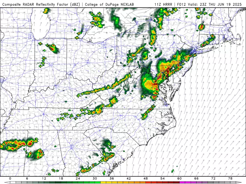
The biggest concern here will be damaging winds, potentially gusting over 60 mph. Torrential rain is also likely, which could cause areas of flooding. And the atmosphere will be electric, leading to lots of dangerous cloud-to-ground lightning strikes too. Hail and even a tornado can't be ruled out.

Will everyone in New Jersey see a thunderstorm late Thursday? Yes, probably. Will everyone in New Jersey see a severe or tornadic thunderstorm? Not necessarily — it depends how those ingredients come together, timing, and how widespread the storms become.
The bottom line: You have to stay "weather aware" Thursday. Keep a close eye on changing weather conditions, especially starting mid to late afternoon. If the sky starts to darken and/or you can hear thunder, it is time to hunker down and seek shelter for a bit.
Once storms clear the coast Thursday evening, skies will clear and humidity will start to fall behind the cold front. Overnight lows should be more comfortable, dipping into the mid 60s or so by Friday morning.
Friday NJ weather: A beautiful June day
Really, Friday could be one of the nicest days of the entire summer. The Summer Solstice officially arrives Friday evening at 10:42 p.m.
Amid mostly sunny skies, lower (but not quite "low") humidity, and a fresh breeze, high temperatures on Friday will reach about 80 to 85 degrees. Typical for mid to late June, and quite pleasant.

After six days in a row with rain somewhere in New Jersey, the streak will be broken by a completely dry weather day Friday.
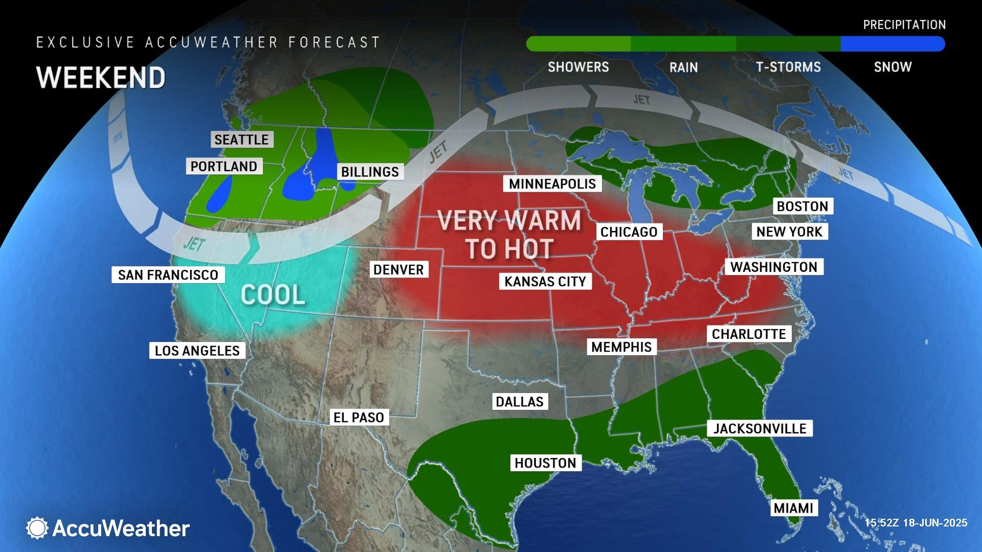
Saturday NJ weather: Pleasant and very warm
Finally a decent weekend! Saturday also looks good, although heat will start to build as the weekend goes on.
Let's call Saturday partly sunny and dry, although an evening popup shower or thunderstorm (isolated) can't be completely ruled out.
Highs on Saturday will bump to about 85 to 90 degrees. That would be totally typical about a month from now, in the "dog days" of late July and early August. Here, it is a perfect excuse to jump in the pool or hit the beach. (Oh boy, the Garden State Parkway is going to busy this weekend!)
Sunday NJ weather: Heat wave begins
Sunday's weather gets even spicier, as temperatures climb even higher. Furthermore, humidity will start dialling up again, adding that thickness to the air we know so well.
Highs on Sunday will end up around 90 degrees. There is some give-and-take in that number — northern and coastal sectors will be slightly cooler, while the hotter southwest corner of the state could come close to 95 degrees.
Skies will become mostly cloudy for a good part of Sunday. Once again, a shower is possible at some point, but most of the Garden State should stay high and dry.
Monday NJ weather: Heat wave intensifies
It is becoming clear that next week will mark New Jersey's first heat wave of the year.
My latest forecast puts highs mainly in the 90s for Monday, Tuesday, and Wednesday. A few 100+ degree temperatures are possible each of those three days. At the very least, the heat index ("feels like" or "apparent" temperature) will be around the triple-digit mark, putting us in "dangerous heat" territory. Yes, you should get some relief from the heat at the beaches — I am sure the Jersey Shore will be very busy through the first week of summer.

Rain chances will be minimal next week, and skies will be bright and sunny. What a difference from the cloudy, drizzly, cool weather of the past few weeks, huh?
11 reasons why storm chasing in NJ is a very, very bad idea
Gallery Credit: Dan Zarrow
Dan Zarrow is Chief Meteorologist for Townsquare Media New Jersey. Follow him on Facebook for the latest forecast and realtime weather updates.
BEEP BEEP BEEP: These are the 13 types of Wireless Emergency Alerts auto-pushed to your phone
Gallery Credit: Dan Zarrow
More From New Jersey 101.5 FM


