

Springlike warmth and sunshine continue, but not for all of NJ
The Bottom Line
Wow! I can't believe how warm temperatures soared on Tuesday! Widespread 60s! New Jersey's first 70s of 2021! (At Manninton Twp, Mansfield, and West Depford)
The next three days also look splendidly springlike and generally pleasant. However, thanks to a pesky on-shore breeze, temperatures will step backwards a bit Wednesday. Especially along the Jersey Shore. And we do have to talk about some raindrops coming up on Friday too.
Wednesday
The most important factor in the forecast here is a wind shift, from northwesterly to southeasterly. (Remember: we report the direction the wind blows from.)
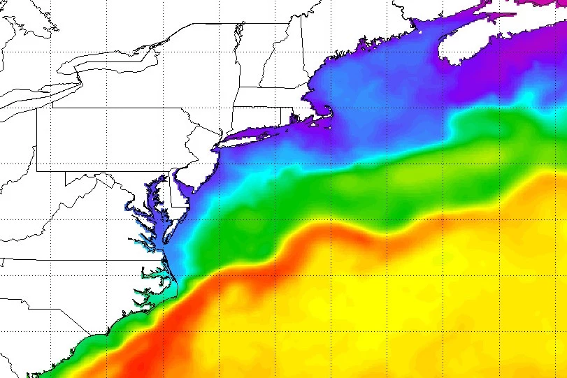
Meanwhile, the Atlantic Ocean right now is hovering at 40 degrees. Definitely chilly! Even though that on-shore wind won't be all that strong Wednesday (no more than 15 mph), it will be enough to blow chilly marine air toward the Jersey Shore. This is not an unusual springtime phenomenon - it literally happens every year.
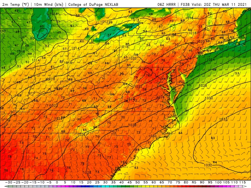
For the majority of inland New Jersey, thermometers will aim for 60 degrees (or better) Wednesday afternoon. Just one small step back from Tuesday.
In our coastal communities, especially on water-surrounded barrier islands, you could be stuck in the 40s all day. A giant leap downward compared to Tuesday.
It'll still be a pleasant, bright and sunny, and dry day, no matter where you are. Just keep in mind the east-west temperature gradient will be notable. And if you plan on going for a walk along a beach or boardwalk, you will need a jacket or sweater.
Wednesday night will be cool, but not too cold. In fact, it could be our warmest night of the year so far. Lows will dip to around 40 to 45 degrees for most. There could be some 30s in the usual cold spots (NW NJ and Pine Barrens).
Thursday
Piecing together all the data, I'm declaring Thursday to likely be New Jersey's warmest day of the week! Inland highs will soar to about 70 degrees. The beaches will be better too, pushing into the 50s Thursday afternoon. (In case you're interested... This time around, the coastal chill won't be driven by an ambient southeasterly wind, but rather a more traditional sea breeze.)
We'll see a pleasant mix of clouds and sun across the state Thursday. The daytime hours will be dry, although a late-night shower can't be ruled out.
Friday
One more warm day, but it's not a perfect forecast. Skies will be mostly cloudy to overcast. And at least a few raindrops are expected to fall.
There are some differences amongst our model forecasts regarding the spread of that rain. The GFS shows spotty showers. The NAM paints a batch of steady light rain over South Jersey during the day, perhaps totaling a half-inch. I've opted for a middle-ground approach for now, calling for a round of scattered showers. In any case, there's no threat of wintry weather, severe weather, and/or flooding.
Highs will mainly reach the mid 60s on Friday, with a stiff breeze.
The Weekend & Beyond
The greatest tragedy of the week is that the springlike warmth will not last into the weekend. By Saturday morning, temperatures will have tumbled to below freezing. And we'll only see highs in the mid to upper 40s. Not quite an "arctic blast" - we're just getting knocked back closer to seasonal normals. Skies should become mostly sunny for most of Saturday too.
45 to 50 on Sunday, with more sunshine. The breeze may kick up a bit on Sunday, as a reinforcing shot of cold air arrives.
Monday gets a little tricky, with a storm system forecast to pass just south of New Jersey. On the cold side of the storm, there is a reasonable chance for some snow and/or wintry mix - if it tracks close enough. I don't want to dig into too many details at this point. It'll just be another thing to watch as we enter the final week of winter. (The Vernal Equinox - the start of Spring - is next Saturday 3/20 at 5:37 a.m.)
Dan Zarrow is Chief Meteorologist for Townsquare Media New Jersey. Follow him on Facebook or Twitter for the latest forecast and realtime weather updates.
More From New Jersey 101.5 FM


