Rough weather ahead Thursday: High Wind Warning, Flood Watch for NJ
UPDATE as of 11:40 a.m. Thursday...
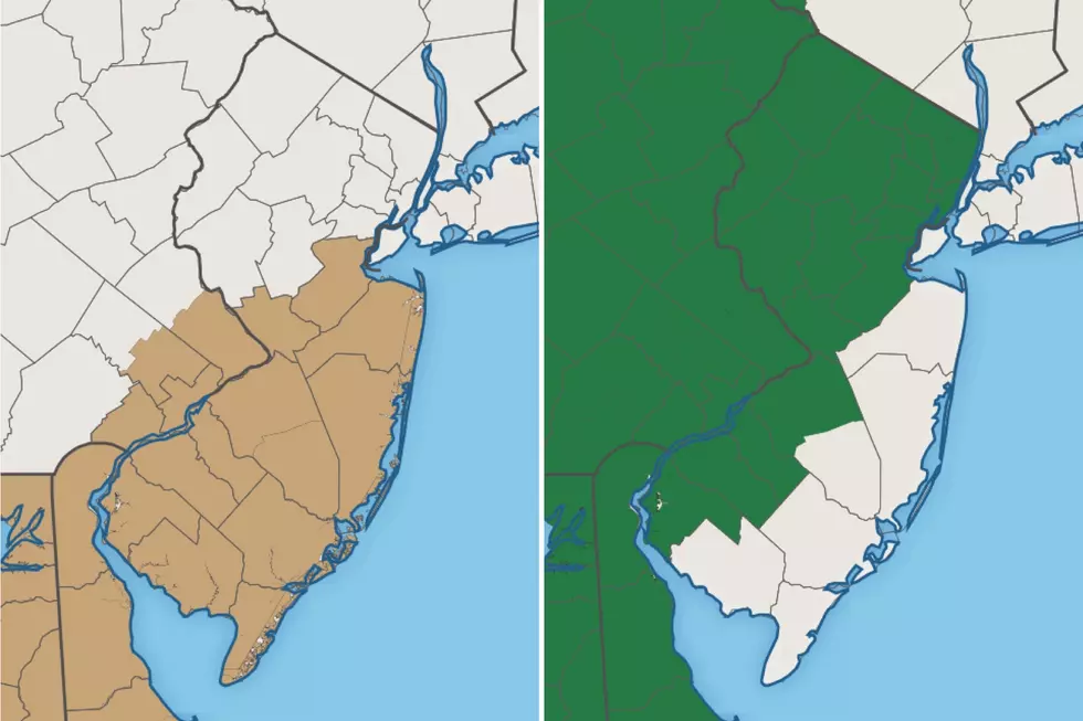
The National Weather Service has upgraded their previous advisory to a High Wind Warning for all of southern and coastal New Jersey, in effect until 8 p.m. This warning now includes Monmouth, Ocean, Atlantic, Cape May, Cumberland, Salem, Gloucester, Camden, and Burlington counties. Power outages will be a deep concern Thursday afternoon and evening, as the strongest winds arrive. (We've already had a 43 mph gust reported at Lower Alloways Creek Township in Salem County.)
A Wind Advisory now coverage Mercer and Middlesex counties, still until 8 p.m. Joining the advisory are parts of four counties in the northeast corner of New Jersey: eastern Bergen, eastern Essex, eastern Union, and Hudson.
No changes to the Flood Watch, which still covers all or part of 16 NJ counties from Thursday afternoon through Friday afternoon.
Unfortunately, there's a bug in our weather mapping software which is causing our warnings display to not update in realtime. I'm working on it — for now, just know that the advisory maps posted in this article are not quite correct.
ORIGINAL POST from 6:13 a.m. Thursday...
We've made it to the last day of April! And we're about to close out the month with an active weather day. This storm system will play out in two distinct parts: first the wind, then the rain. Which of those weather hazards will be more impactful? It depends where you are.
As we begin this Thursday morning, I would call it "breezy," especially along the Jersey Shore. Temperatures are most definitely on the mild side, mainly in the 50s, thanks to some humidity in the air.
By Thursday late morning, a gusty southeasterly wind will start to kick up. Top gusts will come from Thursday afternoon through early evening, between about 40 and 50+ mph. The strongest winds will be found along southern and coastal New Jersey.
A High Wind Warning has been issued for Cape May and coastal Atlantic counties from 10 a.m. to 8 p.m. A Wind Advisory covers the same time frame for the rest of southern and central New Jersey: inland Atlantic, Burlington, Camden, Cumberland, Gloucester, Mercer, Middlesex, Monmouth, Ocean, and Salem counties.
In addition to getting blown away, it's going to look and feel rather unsettled. Cloudy and showery. High temperatures will bump up a few degrees, to the seasonable lower to mid 60s.
Thursday evening, our attention will turn from the wind to the rain. It looks like the "main event," the band of heaviest rain, will push into southwestern New Jersey around 5 p.m. By 8 or 9 p.m., rain should be pouring across the entire state. Rainfall totals will range from just less than an inch along the southern coast to 2+ inches for part of North Jersey. That's enough to cause some flash flooding issues overnight. The band of heavy rain will exit the Garden State between about 2 a.m. and 6 a.m. Friday morning.
A Flood Watch is posted for northern and western New Jersey, from 2 p.m. Thursday until 2 p.m. Friday. Counties in the watch include Bergen, NW Burlington, Camden, Essex, Gloucester, Hunterdon, Mercer, Middlesex, Morris, Passaic, Salem, Somerset, Sussex, Union, and Warren.
So just to recap, Middlesex, Mercer, NW Burlington, Camden, Gloucester, and Salem counties fall under both the Wind Advisory and Flood Watch. A pretty nasty streak of weather here. And a good reason to remain weather aware all day.
It's also worth mentioning that no coastal flood alerts are posted. The threat for long-distance, long-duration surge is long. However, with the fierce wind blowing from the southeast (an on-shore wind), seas could get choppy and overrun vulnerable banks and bulkheads for a brief time.
On the backside of this storm system Friday, there will be a few showers and even thunderstorms around New Jersey. (Models suggest the best chance for raindrops will be Friday afternoon.) We'll remain on the mild side, with highs in the mid to upper 60s. (70s is a possibility for inland South Jersey.) While clouds will win the sky, you might catch a peek of sun late-day.
The forecast for the weekend still looks good, although not quite perfect. For Saturday, we're looking at a dry, breeze, partly sunny day. We're technically under the influence of a cold front, but our new air mass won't be that cold — high temperatures will mainly reach the mid to upper 60s.
On Sunday, thermometers should push into the lower 70s. But the warmth will come with lots of clouds, and a chance for some late-day rain showers (from about 4 p.m. on).
Forecast guidance diverges significantly after this point, with the Euro model painting a rainy shortwave on top of us Monday morning. I'm going with a more optimistic mostly sunny forecast for Monday, with highs still around 70 degrees.
A cooldown will arrive by midweek next week, with temperatures probably stuck at or below normal through at least Mother's Day Weekend.
Stay alert and be safe in the wind and the rain!
Dan Zarrow is Chief Meteorologist for Townsquare Media New Jersey. Follow him on Facebook or Twitter for the latest forecast and realtime weather updates.
More From New Jersey 101.5 FM


