
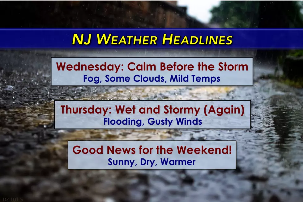
Quiet weather for NJ Wednesday, heavy rain returns Thursday
Wednesday's forecast for the Garden State includes dense fog, sun and clouds, and mild temperatures as another storm system is expected for Thursday.
Here are your weather headlines for Wednesday, April 5, 2017...
Mostly Mild, Quiet Wednesday
Well, Tuesday featured quite the interesting mix of weather across the Garden State. For North Jersey and along the Jersey Shore, it was cloudy and drizzly and grey and cool. In South Jersey, sunny and warm. At 78 degrees, Atlantic City International Airport in EHT broke the previous daily record high of 77 degrees set in 1999.
The combination of wet ground, moist air, and mild temperatures has lead to some thick fog developing across most of New Jersey on this Wednesday morning. Visibilities are below a mile in many spots, which will probably slow you down for the morning commute.
Most fog will burn off between sunrise and mid-morning Wednesday. I'm a little concerned about the coastline, which may be plagued by fog and low clouds for most of the day. Otherwise, we'll see mostly to partly sunny skies and mild temperatures in the mid 60s through Wednesday afternoon. A pleasant, quiet weather day. And the calm before the storm.
Another Wet, Stormy Day
Yet another storm system will affect New Jersey Wednesday night. This will be our third big rainmaker in a week! And this system will have some teeth.
Initial showers will bubble up from the southwest after Midnight early Thursday morning. Rainfall intensity will become significantly heavier by late morning Thursday. After several hours of moderate to heavy rain, things should taper off by late afternoon Thursday. Lingering showers will taper off Thursday night.

Flooding is possible, if not likely, from this system. The ground remains saturated from the last two rain events. Rivers, creeks, and streams are still running high (some spots at or close to flood stage). So it's not going to take much rain to cause some significant headaches.
The National Weather Service has issued a Flood Watch all or part of 17 NJ counties: Bergen, northwestern Burlington, Camden, Essex, Gloucester, Hudson, Hunterdon, Mercer, Middlesex, western Monmouth, Morris, Passaic, Salem, Somerset, Sussex, Union, and Warren.
In addition, the atmosphere will be charged with some instability, so embedded thunderstorms might on the strong side. Of course, every thunderstorm is potentially dangerous due to the threat of cloud-to-ground lightning. Gusty 50+ mph winds will also be a risk on Thursday.
I also want to mention that the temperature forecast for Thursday carries an abnormally high degree of uncertainty. As the center of this low pressure system passes directly over New Jersey, the counter-clockwise circulation could cause a 15+ degree temperature difference from top to bottom of the state. I am quite confident we'll stay way above freezing. Otherwise, don't be surprised to see 50s and/or 60s. Feel free to use a dart board if you need a more specific forecast than that.
Bottom line for Thursday... It's going to be an all-around nasty day. Probably a washout.
Some Improvements Friday
By Friday, the bulk of our storm system will be pushing further and further east. We'll still be plagued by clouds and a chilly brisk wind, limiting high temperatures to the lower to mid 50s. I also can't rule out a few showers, especially late-day Friday. Depending on timing and temperatures, there could be some snowflakes mixing in among NW NJ's higher elevations. But no accumulation is expected.
Sunnier, Drier, Warmer!
Brighter weather is ahead for the weekend, as skies become mostly sunny by Saturday morning. High temperaturess will still struggle to make it to normal on Saturday, limited to the lower 50s. A brisk northwesterly wind will continue on Saturday too.
Sunday will be about 10 degrees warmer than Saturday, as a southwesterly flow sets up a nice warming trend. Highs will be in the lower 60s, under mostly sunny skies. Beautiful.
It gets even warmer through early next week, with 70s taking over the state for Monday and Tuesday. I wouldn't be surprised if we make a run for 80 degrees at some point next week.
Our next storm system threat and next chance of rain will be next Wednesday night into Thursday.
Dan Zarrow is Chief Meteorologist for Townsquare Media New Jersey. Follow him on Facebook or Twitter for the latest forecast and realtime weather updates.
More From New Jersey 101.5 FM


