
NJ’s first widespread frost of the season expected Tuesday night
The Bottom Line
Jacket weather has returned to New Jersey. While the next three days will not be the coldest of the season so far (thanks to the "remnants of Ian" mess in early October), it is going to be unseasonably cool. Feeling November-ish, in fact. And, as overnight low temperatures dip into the 30, we will face our first widespread frost/freeze of the season Tuesday night.
Temperatures will moderate by the weekend. And rain chances will be very limited for the next week or two.

Tuesday
The area of low pressure responsible for Monday's cold front is still spinning over the Great Lakes. So we still have some leftover clouds sitting over New Jersey to start Tuesday. Based on radar trends and our newly-arrived dry air, the chance of raindrops going forward is very low. Sunshine will emerge from late morning through early afternoon.
But we are definitely back in "jacket weather" Tuesday, with morning lows mainly in the 40s and afternoon highs forecast to only reach the mid 50s. That is more than 10 degrees cooler than Tuesday. And about 10 degrees below normal for mid-October.
Let's talk about frost. Those little ice crystals that form on grass, house roofs, and cars on especially chilly mornings. It does not need to be "below freezing" (< 32 degrees) for frost to form. With calm winds, cold air pools right at the surface. So an air temperature of 37 degrees is generally enough for frost to form.
That is exactly what will happen Tuesday night into Wednesday morning. Most low temperatures will dip into the 30s. The notable exceptions: city centers and coastal areas will miss the frost potential, with lows in the lower 40s.
The first frost/freeze of the season is critically important for gardeners and farmers. Otherwise, there's nothing inherently "dangerous" about temperatures in the 30s.
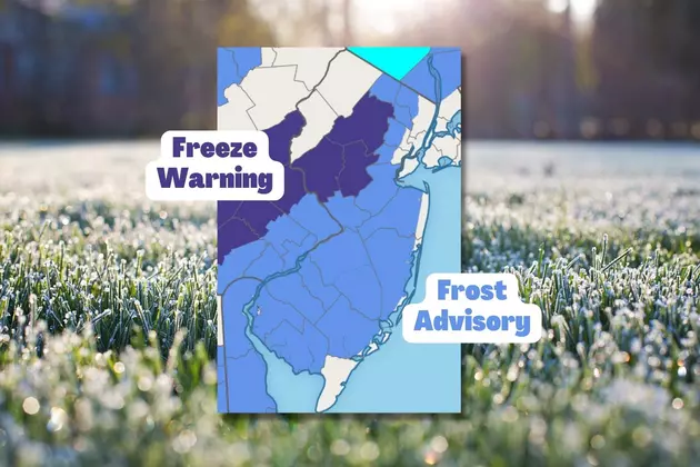
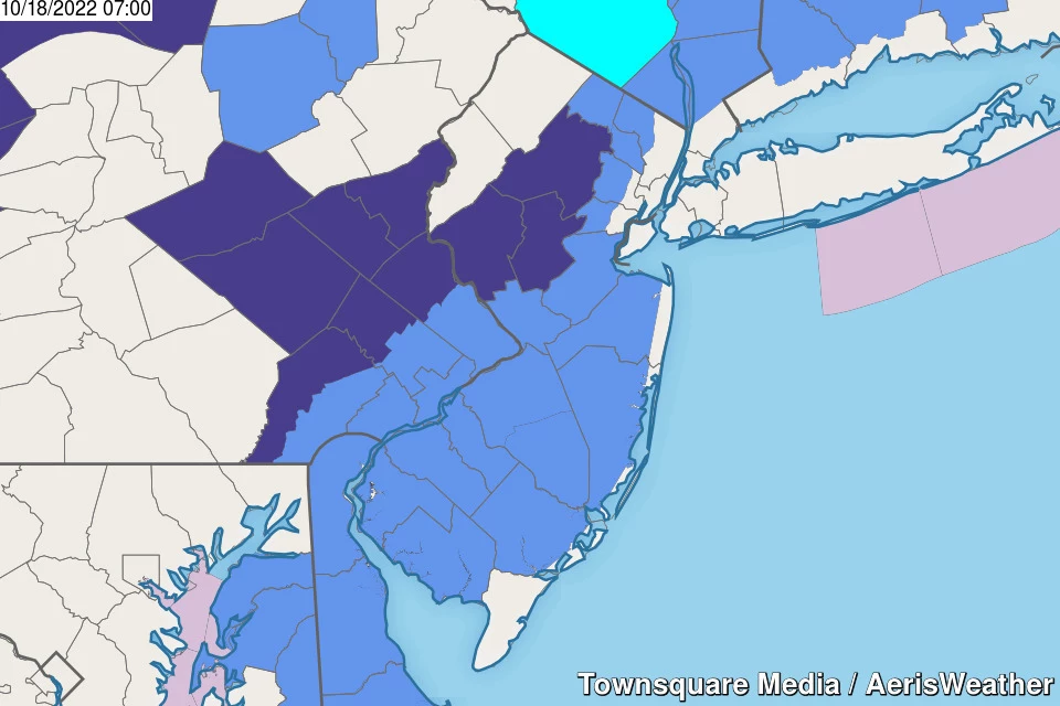
There are Freeze Warnings and Frost Advisories posted for most of New Jersey. That includes:
—Freeze Warning... Hunterdon, Morris, and Somerset counties. The temperature may drop to 32 degrees overnight.
—Frost Advisory... inland Atlantic, western Bergen, Burlington, Camden, Cumberland, western Essex, Gloucester, Mercer, Middlesex, inland Monmouth, inland Ocean, Passaic, Salem, and western Union counties. The temperature may drop to 37 degrees overnight.
—No Warning/Advisory... Sussex and Warren counties. The temperature may drop to 32 degrees overnight. That has already happened this season — the growing season already ended.
—No Warning/Advisory... coastal Atlantic, eastern Bergen, Cape May, eastern Essex, Hudson, coastal Monmouth, coastal Ocean, and eastern Union counties. Low temperatures in the upper 30s to lower 40s will too warm for frost to form.
Wednesday
Definitely cool. The bottom of the barrel of this cool stretch, in fact.
Not only will high temperatures only reach the lower to mid 50s Wednesday afternoon, it will be breezier. Any little wind will make you feel the cool air even more.
Models are painting plenty of sunshine for Wednesday, with the possibility of clouds in the afternoon. A couple of solutions favor a light shower around dinnertime — but I have opted for a dry forecast, given our very dry air mass.
Another widespread frost looks likely for Wednesday night to Thursday morning.
Thursday
We'll start to dig out of the cool hole, but you'll still want a jacket or sweater Thursday.
Sunny, breezy, and mid 50s. That's about it. About a month from now, that would qualify as a pleasant November day.
Friday
As I mentioned, temperatures will moderate toward the end of the week. Friday's high temperatures will push into the lower 60s. (And I'm admittedly being a bit hesitant and conservative with the warmup so far.)
Friday will be a partly sunny day, with some extra cloud cover as a weak disturbance rides through our atmosphere. An isolated shower is possible during the daytime hours. But only enough to spit a few hundredths of an inch of rainfall in spots.
The Weekend & Beyond
Sunshine and 70 degree temperatures return for the start of the weekend. Pleasant weekends in the fall are just wonderful, given how many outdoor activities are happening in the grand leadup to Halloween.
On Sunday, a storm system approaching from the southeast will at least increase cloud cover. That will have only a slight effect on temperatures, so we should still end up close to 70. The European model does put some rain over New Jersey starting Sunday afternoon. It's a new development, and I'm not totally convinced — just something to watch for now.
If that rain chance does not pan out, next week will be mild and quiet. Our next substantial, widespread chance of rain wouldn't be until late next week.
Dan Zarrow is Chief Meteorologist for Townsquare Media New Jersey. Follow him on Facebook or Twitter for the latest forecast and realtime weather updates.
NJ words that should be added to the dictionary
Gallery Credit: Steve Trevelise
Famous NJ people from A to Z (almost)
More From New Jersey 101.5 FM


