

NJ weather: Heat humidity raindrops, lather rinse repeat
The Bottom Line
The big weather story here continues to be heat and humidity, with occasional showers and thunderstorms thrown in too. In fact, practically every day of the next week could bring a few raindrops to New Jersey. Sounds like typical late July-early August weather to me.
At least one weather station in New Jersey has hit 90+ degrees since Saturday. So Wednesday will be Jersey heat wave day #5. And, although there will be some up and down variations in temperatures, that count could reach about 13 by the time we get sustained relief late next week.
Those numbers are impressive. And this summer has been abnormally, uncomfortable hot. But remember, I like to break heat into three categories:
1.) Regular hot summer days, in the 80s.
2.) Unseasonably hot days, where thermometers break 90 degrees.
3.) Extreme heat — dangerous heat — where the heat index soars well over 100.
We are only talking about the second category throughout this forecast. Unusually, uncomfortably hot and humid conditions. We're not breaking any records this time around. But it will be another grind of day after day after day of sweaty, sweltering weather.

Wednesday
We begin the day with some rain pushing through the state. Spotty to scattered showers have been popping up all morning. Enough to put some puddles on the ground and knock back temperatures a couple degrees. But no change to the humidity at all.
I have to keep hit-or-miss showers and thunderstorms in the forecast throughout the daytime hours today. Nothing crazy, just isolated to spotty. Realistically, those rain chances will decrease through the afternoon. Skies will progress from mostly cloudy to partly sunny, as clouds also thin out.
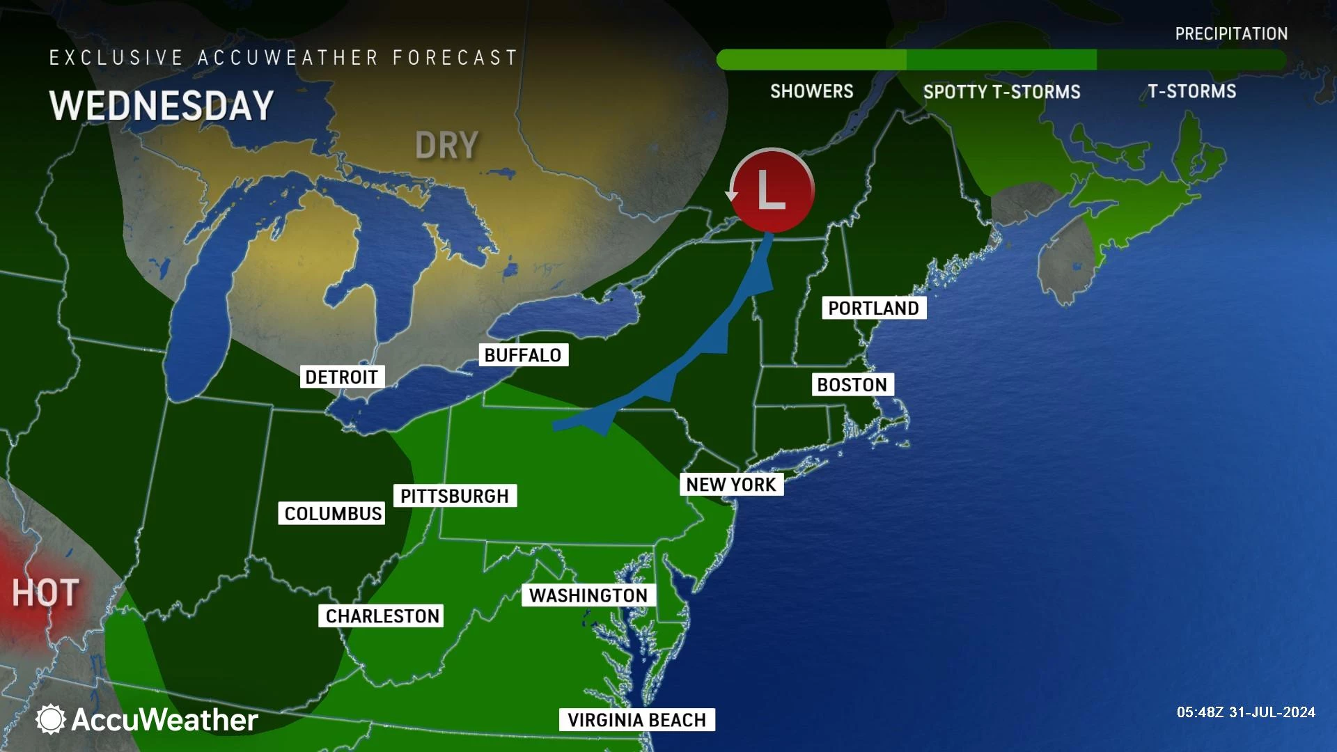
Morning temperatures are firmly in the 70s — not cool at all. Afternoon high temperatures are forecast to reach about 85 to 90 degrees. Where you end up in that range depends upon cloud cover, whether you see a shower or not, and proximity to the coast.
Wednesday night, skies will continue to clear, as our air stays muggy. Look for lows only falling into the lower 70s at best.
Thursday
I think rain chances dial back a lot for Thursday, with only an isolated popup shower opportunity in the afternoon.
Humidity levels may also scale back slightly on Thursday. But temperatures will be about 5 degrees hotter than Wednesday. So it will still be a steamy start to the month of August.
With lots of hazy sunshine, high temperatures will soar to about 90 to 95 degrees on Thursday. The heat index may very well approach triple digits.
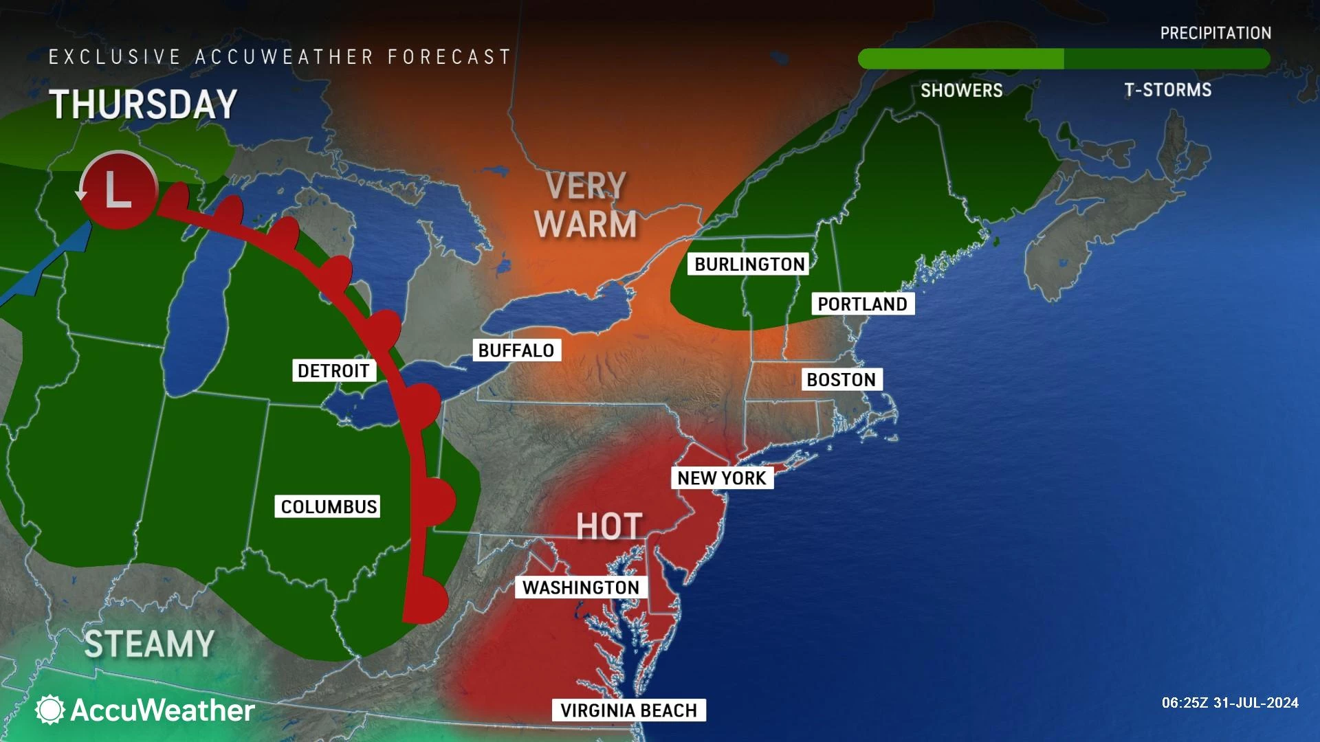
A Heat Advisory has been issued for almost all of New Jersey from 10 a.m. Thursday to 8 p.m. Friday. Think of that as a formal heads-up to take the heat seriously, and take care of yourself. Dress appropriately, take frequent breaks, and stay extra hydrated.
Friday
Again, that Heat Advisory rolls into Friday too, as high temperatures return to the lower-mid 90s. Thursday and Friday look to be the hottest days of this stretch.

Most of the day will be partly sunny and quiet. A fairly organized impulse is expected to push into Friday late-day — possibly in the afternoon, more likely in the evening hours. That will probably spark a widespread round of showers and thunderstorms. Stronger storm cells are possibly, given the energy (heat) and moisture (humidity) in the atmosphere. So it will be an "eyes on the sky" situation for potential severe weather.

Saturday & Sunday
It's not all rainbows and unicorns in this weekend's forecast. First, Saturday and Sunday look to be the most humid days of this stretch. Second, there will be some raindrops around the Garden State.
High temperatures on Saturday and Sunday will be close to 90 degrees. Model guidance is showing dew points up to the mid 70s — that is disgustingly thick, tropical air.
There will probably be more clouds than sun for the bulk of the weekend.
Also, later Saturday into early Sunday, a weak cold front will probably fire off some shower and thunderstorm activity. Forecast models are still all over the place regarding the potential spread of this rain — ranging from isolated popups to widespread scattered. I would say Saturday afternoon and evening poses the best rain chance of the weekend.
In either case, I do not think you have to change or cancel your plans yet. Just stay as flexible as possible, and pay attention to the forecast as it firms up.
The Extended Forecast
No big changes as we dive into the first full week of August next week. Hot and humid, with a practically daily thunderstorm chance.
When will we taste relief? A weak front early in the week will push humidity levels down, which will help. But the air will still be hot and summer-ish.
A stronger cold front is forecast by both the GFS and Euro models to arrive next Friday. That would cause a significant drydown along with a noticeable cooldown. We will be angry and totally over the heat wave by that point, so the improvement will be welcomed. (However temporary it may be.)
Look for these NJ athletes at the Paris Olympics
Gallery Credit: Erin Vogt
Dan Zarrow is Chief Meteorologist for Townsquare Media New Jersey. Follow him on Facebook for the latest forecast and realtime weather updates.
POP QUIZ: Can you guess these NJ landmarks from Google Earth images?
Gallery Credit: Dan Zarrow
More From New Jersey 101.5 FM


