
Heavy snow and wind on track for Sunday: Blizzard Warning issued for part of NJ
1.) Latest Storm Update
Wow. This storm has gone from "worth watching" to "the ingredients are coming together" to now a potential monster, historic winter storm for New Jersey. As of Saturday morning, multiple forecast models are painting over 30 inches of snow accumulation over part of New Jersey within just 24 hours.
My forecast does not go quite so high, as I still hold a couple hesitations and reservation. However, it is becoming clear we are looking at a lot of snow and downright dangerous conditions across New Jersey from Sunday into Monday.
You can go buy your bread and milk now. What a storm. What a winter.
2.) Warnings and Watches
The National Weather Service has issued a Blizzard Warning for the Jersey Shore:
—10 a.m. Sunday to 6 p.m. Monday... Southeastern Burlington, Monmouth, and Ocean counties
—1 p.m. Sunday to 6 p.m. Monday... Atlantic and Cape May counties
(I assume the timing difference has to do with the potential for rain and mixing at the onset Sunday.)
Blizzard conditions have four very specific requirements:
1.) Sustained winds or frequent gusts of 35+ mph
2.) Blowing or falling snow (the definition has no set "accumulation" requirement)
3.) Visibility at or below a quarter-mile
4.) For at least three hours
The Blizzard Warning product is among the most serious and urgent issued by the NWS. The last time we had one issued in New Jersey was for the January 28-29, 2022 snow storm, also along the Jersey Shore.
A Winter Storm Warning covers the rest of the state, for the following time frames:
—4 a.m. Sunday to 6 p.m. Monday... Hunterdon, Mercer, Middlesex, Morris, Somerset, Sussex, and Warren counties
—6 a.m. Sunday to 6 p.m. Monday... Bergen, Essex, Hudson, Passaic, and Union counties
—10 a.m. Sunday to 6 p.m. Monday... Northwestern Burlington, Camden, Cumberland, Gloucester, and Salem counties
The only condition needed for a Winter Storm Warning in NJ is 5-6+ inches of snow. Visibility may be severely reduced due to falling and/or blowing snow, and travel will be very hazardous during the height of the storm.
Additionally, a Coastal Flood Watch has been issued for the Jersey Shore:
—9 p.m. Sunday to 5 a.m. Monday... Atlantic, southeastern Burlington, Cape May, Middlesex, and Monmouth counties
One round of moderate category flooding is expected along tidal waterways Sunday night. Another push of minor flooding is possible Monday afternoon.
3.) Timeline
Saturday... No problems, allowing plenty of time for pre-storm preparations. Expect a mix of clouds and sun, with light winds and seasonable temperatures. Highs in the 40s.
Sunday Morning... The storm will start relatively slow. Spotty showers will begin just before sunrise Sunday, spreading north and east throughout the morning. For the southern half of the state, initial precipitation may be wintry mix or straight rain with temperatures in the mid 30s. It may take a while for any snow to stick, due to a relatively warm and wet ground.
Sunday Afternoon... As low pressure draws closer and starts to intensify, storm conditions will start to pick up in the early afternoon. Any areas of rain or mixing will switch over to all snow by early afternoon. Snowfall will become heavier and more widespread by late afternoon.
Sunday Evening... This is when you really need to be hunkered down, as we enter the real "brunt" of the storm. Persistent bands of heavy snow (1 to 2+ inches per hour) will make driving conditions almost impossible, especially along southern and coastal New Jersey.
Sunday Overnight... Moderate to heavy snow continues. Some accumulations will pass the one foot mark by Midnight.
Monday Morning... Still snowing. Expect widespread school cancellations Monday. Snow intensity should start to dwindle just after sunrise, but accumulations will continue. And travel conditions will be terrible statewide.
Monday Midday... Snowfall will finally start to taper, from west to east. But that doesn't mean you'll be going anywhere anytime soon. It will take some time for crews to clear double-digit snowfall from even major roads. Be sure to start shoveling ASAP Monday, and pace yourself — the snow will be very heavy and wet.
Monday Afternoon... Storm is done by late afternoon. Cold wind and cleanup continues.
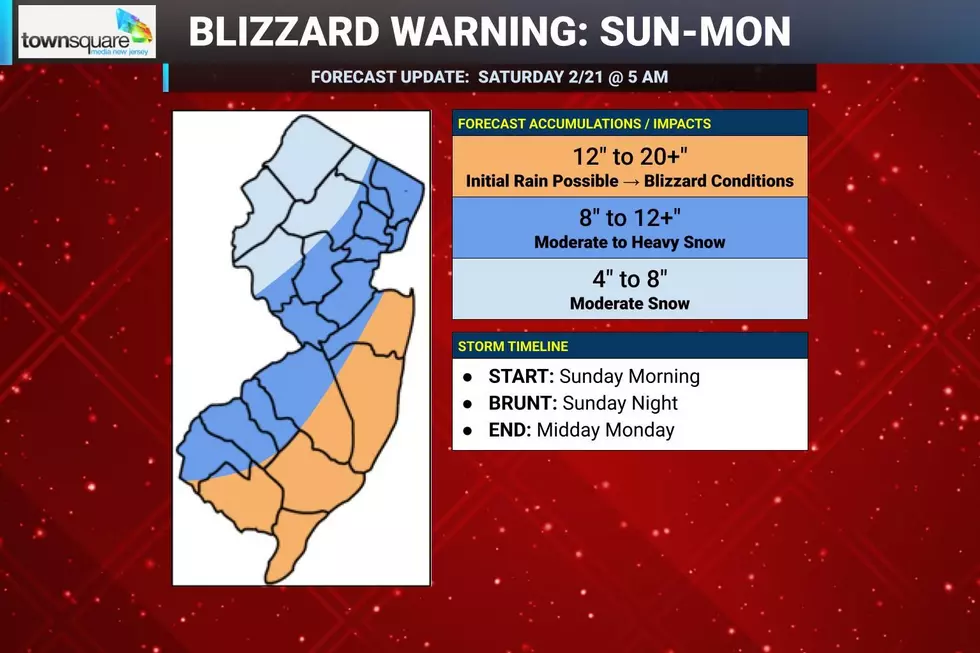
4.) Snow Accumulations
As I mentioned above, our forecast models are painting almost a "perfect snow storm" setup for this thing. The placement, strength, and temperatures represent an ideal snow machine for specifically the Jersey Shore. If those forecasts actually verify.
I'm a little worried those high-end models are pumping too much moisture and cold air into the storm, and that's why they're spitting out 3+ inches of liquid precipitation and 30+ inch snow totals. I have the usual winter storm worries of a last-minute storm track wiggle, dry-slotting, and warm/wet antecedent ground conditions — I have just been burned too many times before. And of course, there is still the almighty European model that stands alone in showing a farther-away and weaker storm. (I will further address how the forecast might change going forward in the next section.)
Having said all that, it is clearly time to pull the trigger on big double-digit snow totals for most of the state. Especially in the bullseye "sweet spot" along the coast, where snowfall will be the heaviest.
For the southern and coastal edges of the state, I am now predicting 12 to 20+ inches of snow accumulation from Sunday to Monday. That is a lot of snow. And it will be heavy and wet. While it may start as rain or wintry mix Sunday morning, a flip to all snow will happen well before the 1-2" an hour snowfall rates kick in. The "plus" means some areas may overperform, with isolated totals up to two feet. Travel will be impossible, blizzard conditions are possible, and cleanup will take days not hours.
For most of inland New Jersey, on either side of the Turnpike corridor, I argued with myself for a long time about just how high to ramp up the snow forecast. And I landed on 8 to 12+ inches — in other words, there is a good chance of significant, impactful, double-digit snowfall through the heart of New Jersey. The "plus" indicates that totals could go as high as 14" or 16". (Really, how are you going to prep differently for a 16" snow storm than a 12" storm?) And I may need to ramp the forecast up even more if the storm maintains its snowy strength.
Northwestern New Jersey, this is not your storm, but you are still going to see some substantial snow accumulations with a piece of inland energy also in play. I have cast a wide net here of 4 to 8 inches. While you will fall squarely outside of the heaviest snow bands, it will be colder here — yielding fluffier, faster-accumulating snow. Still wintry, just not a blizzard-ish burial like at the Shore.
5.) How This Forecast Could Change
No weather forecast is complete without a measure of confidence — how certain the forecaster is that the situation will actually come true. I have not been shy or ashamed to admit this coastal storm has been a very volatile, uncertain situation. And to a certain extent, it still is.
While we now have good consensus among model guidance (and among the meteorologist community) that this is going to be a significant snow storm for New Jersey, the storm track may still "wiggle" slightly. And even a last-minute shift of 30 to 60 miles can make for huge differences in the ultimate impacts of a storm.
I have accounted for that possibility in this forecast, and for the fact there are still 24 hours to go before the storm arrives. And that I still have two more opportunities to update this forecast: Saturday afternoon and Sunday morning.
My basic thinking and strategy is this:
If the storm ends up wiggling away from the New Jersey coastline, or if the forecast trends slightly drier or warmer, I can downgrade each sector of my snowfall map by one category. So instead of 12-20+, 8-12, and 4-8 inches, it would become approximately 8-12, 4-8, and 2-4 inches. Bust.
On the other hand, if the truly worst-case, heavy-duty model solutions do hold firm and this turns into a blockbuster, record-breaking storm, I might have to upgrade each sector of my snowfall map by one category. So instead of 4-8, 8-12, and 12-20+, I would shift to something like 8-12, 12-20, and 20-30 inches. Yikes.
As I have said, forecasting 2 to 3 feet of snow in New Jersey is a stretch. I have to be absolutely sure, with no hesitations. I'm not quite there — but we might get there, depending how things trend over the final 12 to 24 hours before arrival.
6.) What to Do Now?
Now that the forecast for a significant storm is firming up, the time has come to rush any storm preparations to completion. If you haven't done your grocery shopping yet this week, you will definitely have some company Saturday. Home improvement and hardware stores will be busy too.
Now that warnings and a State of Emergency have been issued, consider your plans for Sunday and Monday very carefully. Driving will become an increasingly bad idea by mid to late afternoon. Airlines will suffer delays and cancellations, which will cascade throughout the country for days to come. I expect widespread school closures on Monday — and I doubt the hardest hit areas will be back in session on Tuesday or Wednesday either.
And don't sleep on the wind and power outage threat. Make sure you have batteries and flashlights handy, keep your devices charged, and have warm blankets ready in case the power goes out in the middle of the storm.
Hold on tight, here we go. Can we officially call this The Blizzard of 2026 yet?
Next weather blog update may come Saturday afternoon. Definitely one more update to come early Sunday morning.
Remembering New Jersey's last real blizzard: January 2022
Gallery Credit: New Jersey 101.5 users
Dan Zarrow is Chief Meteorologist for Townsquare Media New Jersey. Follow him on Facebook for the latest forecast and realtime weather updates.
The Blizzard of '96 Revisited: Snow totals for every NJ county
Gallery Credit: Joe Votruba
More From New Jersey 101.5 FM


