

Flood Watch: Scattered thunderstorms return to NJ Wednesday
We have more steamy, stormy weather in the forecast for New Jersey. High temperatures will push to around 90 degrees Wednesday. More importantly, a round of strong thunderstorms will start to develop around mid-afternoon. Flooding is the main concern, along with a chance for some gusty winds. The highest potential for nasty storms will be to the north and west, although everyone needs to stay vigilant to the torrential rain potential. Thursday will be dangerously hot and humid, with highs in the 90s and a heat index over 100. A Heat Advisory has been issued for the entire state. We will finally get some relief from the onslaught of heat, humidity, and storms for the start of the weekend.

Wednesday NJ weather: Flood Watch
Obviously, the memory of Monday's record rain and deadly flooding is still very fresh. And parts of New Jersey are still cleaning up. I think it is only natural for everyone's ears to prick up even more than usual as we once again ring alarm bells for heavy rain and potential flooding. While I will (hesitantly) say, by the numbers Wednesday's impending round of storms and heavy rain and flooding does not look quite as severe as Monday's, we can not let our guard down here. There could still be some nasty storms, damage, and problems on the roads later on for sure.
Wednesday starts quiet and muggy, with temperatures once again in the 70s across the state. Expect a muggy day, with increasing clouds. Highs will top out around 90 degrees for most. The Jersey Shore will end up a bit cooler, closer to 80.
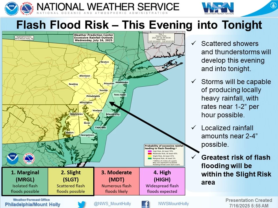
Isolated thunderstorm cells are forecast to pop starting around mid-afternoon, around 3 p.m. give or take. Any storms that do form will be capable of producing very heavy rain, which will be our biggest concern once again. Gusty winds and vivid lightning are on the table too.
The most widespread thunderstorm activity will likely come later, after sunset Wednesday evening. That means the severe wind potential will be lessened. But the heavy rain potential will very much remain alive, given the rich moisture (humidity) in the air.
Rainfall rates could exceed an inch per hour, which alone is enough to inundate storm drain systems and flood low-lying areas including roadways. Rainfall totals could exceed two inches, with an outside chance someone in NJ picks up three or four inches of fresh rainfall. That is a lot of water, and both downpours and runoff could lead to impassable roads, flooded vehicles and basements, etc.
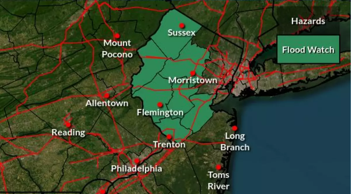
The axis of heaviest rain and strongest storms looks to be to the north and west this time around. The National Weather Service agrees, issuing a Flood Watch for seven New Jersey counties from 3 p.m. Wednesday through 3 a.m. Thursday: Sussex, Warren, Morris, Hunterdon, Somerset, Middlesex, and Mercer.
Remember, a "watch" means the ingredients are there for hazardous conditions. It is a formal heads-up to literally "watch" the weather. If a "warning" is issued for your area, that means the dangerous weather is occurring or imminent. That is when it is time to seek shelter, and stay hunkered down until the storm passes.
Bottom line: Everyone in New Jersey will likely get wet between Wednesday afternoon and Wednesday night. Localized flooding could be severe in spots, especially to the north and west. It will be a good evening to just hunker down and stay home, if possible.
Thursday NJ weather: Heat Advisory
Thursday will feature the chance of lingering showers in the morning. And I can not rule out some popup thunderstorms late-day.
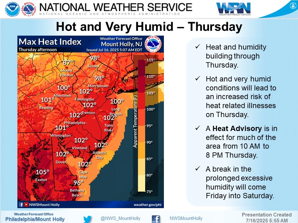
But the big weather story for Thursday will be a big surge of heat and humidity. Highs will reach into the lower 90s, away from the coast. The heat index (the "feels like" or "apparent" temperature) will max out around 100 to 105 degrees.
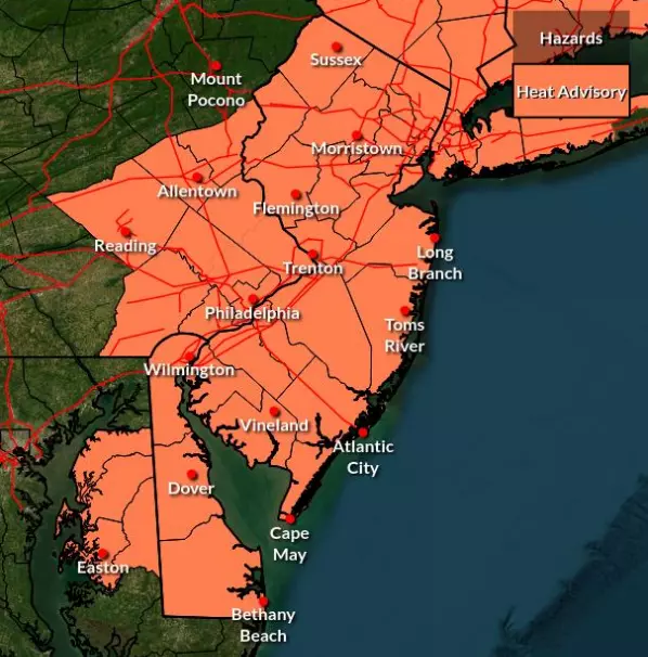
The National Weather Service has issued a Heat Advisory for all counties and all forecast zones in New Jersey on Thursday. You need to take care of yourself in such "dangerous" heat — dress for the weather, stay as cool as you can, and keep extra hydrated.
Friday NJ weather: Sweet relief
Early Friday morning, a cold front will ride through New Jersey. That will deliver our first shot of truly cooler, drier air since the 4th of July holiday weekend.
Dew points will especially drop precipitously by Friday afternoon, making for a much more comfortable day. Temperatures will be 5 to 10 degrees cooler than Thursday too.
So look for highs in the mid 80s. That is seasonable, typical for mid July. But again, the low humidity will be wonderful.
Skies will be partly sunny on Friday. I can not rule out an isolated shower firing up along that frontal boundary, especially in southern New Jersey. But it does look like a mainly dry front and a predominantly dry weather day.
Saturday NJ weather: A beautiful day
Saturday still looks great! Partial sunshine, dry weather, low humidity, and seasonably warm temperatures in the lower-mid 80s. It really does not get much better than that in the middle of summer.
Sunday NJ weather: Mixed news
Sunday will be a "warm front then cold front" day. Whenever weather transitions are in play, you have to assume some turbulent weather. And that is absolutely true here — I am concerned that rain and thunderstorms will interrupt part of your Sunday. But at the same time, I am also hopeful we will be able to salvage the other part of the day.
The most likely timing for rain as it stands now will be Sunday early morning through about lunchtime, as a warm front lifts through the state. There could be some heavy stuff brushing past the state too, which may significantly impact outdoor plans.
Hopefully we will see partial clearing into the afternoon. So with high temperatures back in the mid 80s, it will turn into a good summer day. A noticeable rise in humidity is also likely.
Forecast models show another dry cold frontal passage Sunday night, knocking humidity back again for early next week. That will potentially lead to some fairly comfortable weather. For both Monday and Tuesday next week, I have a mix of sun and clouds, with high temperatures around 80 to 85 degrees. I just can't rule out some late-day showers on either day.
I also fear bigtime heat will build again by the end of next week, back into the 90s.
11 reasons why storm chasing in NJ is a very, very bad idea
Gallery Credit: Dan Zarrow
Dan Zarrow is Chief Meteorologist for Townsquare Media New Jersey. Follow him on Facebook for the latest forecast and realtime weather updates.
BEEP BEEP BEEP: These are the 13 types of Wireless Emergency Alerts auto-pushed to your phone
Gallery Credit: Dan Zarrow
More From New Jersey 101.5 FM


