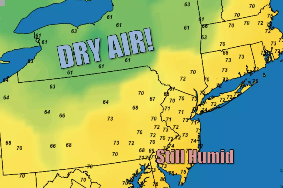
New Jersey will be so close to tasting drier air Wednesday
And yet, so far. A cold front will pass halfway through the Garden State - part of the state will be comfortably warm, while part of N.J. remains quite humid.
The good news? There are no heat warnings or advisories in effect for Wednesday! That's the first time that's happened in about a week.
The bad news? The approaching cold front will get stuck, delivering humidity relief only to the northwest half of the state.
As of this writing, the front and it's drying effect has not yet arrived in New Jersey. So it's another sticky start to the day, with highs in the 70s.
So Wednesday will turn into a "Tale of Two Jerseys" day, dictated by exactly where that front will stall. The precise location is unclear, but it will likely be on one side of the NJ Turnpike. Therefore it's impossible to tell exactly who in the state will enjoy drier air and who will be stuck in the humidity for another day. It's pretty clear that South Jersey and the Jersey Shore will feel the humidity right through Wednesday afternoon.
To the north and west of the front, you'll enjoy dew points in the 60s (or maybe even lower) with plenty of sunshine and highs in the upper 80s. To the south and east of the front, partly sunny skies will accompany the continuing mugginess with highs likely pushing into the lower 90s. There could be a popup shower today too.
Wednesday night, the front will nudge forward and eventually wash out or dissipate completely. That movement will provide enough lift for a round of showers and thunderstorms between about 8 p.m. Wednesday and Noon Thursday. The best chance for pockets of heavy rain will be in the warm, moist sector in South Jersey.
After residual showers wrap up Thursday morning, skies will clear through Thursday afternoon. It should actually turn into a nice day - humidity levels statewide won't be extreme, but they'll certainly be on the high side. Highs temperatures look to top out in the mid to upper 80s, finally breaking our heat wave (8 days in a row of 90+).
Friday will be very warm and mostly sunny. Another solid summer day, as highs return to around the 90 degree mark.
As for the weekend, there will be pockets of good weather sprinkled throughout. While not a perfect forecast, it's certainly going to be better than last weekend's extreme heat and humidity.
Saturday's high temperatures are expected to climb to about 85 to 90 degrees (cooler along the coast). Skies will average partly sunny, and there's a chance of a shower in the afternoon.
Similar temperatures and humidity levels are expected for Sunday. As the south-southeast breeze kicks up to the "breezy" range, I worry that the Jersey Shore might become a bit cloudy and much cooler than further inland.
And then our next cold front arrives in the Sunday night to Monday time frame. First will come a period of potentially steady rain. And then will come... Much cooler, drier air! The forecast for the middle of next week looks fantastic - we'll enthusiastically keep you posted.
Dan Zarrow is Chief Meteorologist for Townsquare Media New Jersey. Follow him on Facebook or Twitter for the latest forecast and realtime weather updates.
More From New Jersey 101.5 FM


