Light snow and rain showers Thursday – lots of rain this weekend
Highway message boards across New Jersey warn of "Winter Weather Thursday". Roads are brined. (Hooray!) Oh yes indeed, we are ready for a little bit of snow!
Key phrase there: a little bit. As we've discussed, the intensity of this storm system is questionable and temperatures will be borderline. Sure, the potential is there for some light snow accumulations and slippery spots throughout Thursday, especially the further north you are. Keep in mind though, the second storm in New Jersey's forecast queue will be more significant, making for a sloppy (read: wet) weekend for the Garden State.
I'm starting to see light echoes on radar moving into the northwest corner of the state. We're pretty much on schedule — peak precipitation is expected from about mid-morning through early afternoon.
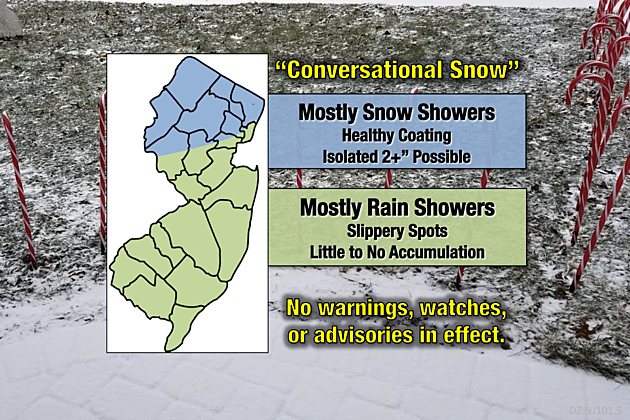
With temperatures hovering around the freezing mark across New Jersey, initial precipitation Thursday morning is likely to be all snow. Very light and widely scattered, I think today's snowfall can be categorized as "conversational snow".
In central and southern New Jersey — below the Interstate 78 corridor — any snowflakes will quickly change over to raindrops as temperatures warm into the 40s. While there could be periods of reduced visibility and a few slippery spots along the way, little to no accumulation is expected and travel issues are unlikely.
Along and north of I-78, this storm system will be slightly more impactful. I'm still thinking a healthy coating of snow accumulation is a good bet, especially on cold, untreated surfaces. Generally not a big deal, especially if roads are pretreated.
Allow me to present 3 ways this "conversational snow" could become more dramatic and more hazardous (i.e. "worst case scenarios):
1.) If it snows persistently all day, locally higher amounts (perhaps a few inches) may come to fruition in North Jersey. Even just 0.1" per hour (hardly anything) would accumulate about an inch (depending on melting and compaction) after a 10-day day.
2.) If a heavier snow band forms, we could conceivably see snowfall rates of a half-inch to an inch per hour. Such a mesoscale band does not need to sit in one spot for long to pile up some healthy snowfall.
3.) If temperatures hover right around the freezing mark and instead of snow, we could get a wintry mix. Or worse, straight freezing rain. (That's liquid rainfall that freezes on contact with a cold surface, like a roadway, car, mailbox, etc.) It doesn't take many frozen droplets to create a very slippery "solid sheet of ice" situation.
While the latest forecast models have backed off the notion of 2-3" of snow accumulating somewhere in New Jersey, I think it's still a decent possibility. (Again, see #1 and #2 above.)
High temperatures Thursday afternoon will range from the mid 30s in North Jersey (just above freezing) to the mid 40s in South Jersey (well above freezing).
As showers taper off completely by Thursday evening, I do not expect skies to clear very much. We'll probably see some fog develop overnight. Low temperatures will end up somewhere in the mid to upper 30s.
Friday will be a quieter and warmer weather day, although not too pretty. Expect cloudy skies, with lingering drizzle and fog possible. High temperatures will soar into the lower to mid 50s for most of the state. It will be our warmest day in almost two weeks (December 2-3).
That warmup will be a huge forecast factor for our next storm system, arriving late Friday night. Saturday still looks like a very wet day for New Jersey — the day may turn out to be a total washout. Pockets of heavy rain may lead to ponding and flooding issues. With highs again in the 50s, it'll be all rain Saturday — nothing wintry.
Although rain will taper a bit and become more scattered (i.e. spread out) Saturday evening, the second half of the weekend looks wet too.
However, Sunday's forecast is tricky. There will be rain for at least the morning hours, but we could end up salvaging part of the afternoon. On the other hand, temperatures will also start falling Sunday thanks to a brisk wind gusts to 30 mph. I think thermometers will stick to the 40s throughout the daytime hours, far enough above freezing to cause concern. But models show some wintry mix coming perilously close to the northern edge of NJ.
Tide models are also suggesting about a foot of surge along the Jersey Shore on Sunday. That's enough for "minor" flooding of coastal waterways. But that forecast is highly dependent on the exact wind speed and direction, so I don't want to put too much emphasis on precise impacts just yet. We'll be watching it through the weekend.
As this huge storm system finally departs on Monday, we could see some snow showers in the cold air on the backside. Models have even suggested some light accumulation, on the order of an inch or so. But I'm dubious — the ground is going to be pretty wet, and forecast high temperatures are still in the lower to mid 40s on Monday.
Looking to see the sun again? You'll have to wait until Tuesday — a sunny and dry, cold and blustery day.
More From New Jersey 101.5 FM


