Ice-rain-snow to snarl travel across NJ Sunday-Monday-Tuesday
Welcome to December. And climatological winter. And New Jersey's first winter storm of the season.
No matter what falls from the sky — sleet, rain, and/or snow — Sunday is going to be pretty messy.
And then Monday looks even worse for part of the state, with residual snow/ice impacts potentially lasting into Tuesday morning.
This weather blog entry is a quick update to the forecasts I've issued previously. For the most part, I've only made some nudges, tweaks, and number massages. For a full region-by-region breakdown of the timeline and impacts of this complicated storm, I recommend you skim through Saturday afternoon's article first.
And just a reminder that our news, digital, traffic, and weather teams are fully mobilized until the messy weather is done.
Forecast Update
—Please keep in mind these two maps are cumulative. I decided to split the potential snow and ice accumulations into Sunday and Monday to make the forecast clearer, and give you a better idea of impacts and timing.
—I tweaked Sunday's top contour slightly to cover more of Hunterdon County and less of Bergen County, based on current model and temperature trends. In this area, we're still concerned about wintry mix (sleet and freezing rain) early Sunday, transitioning to a period of snow later on.
—A friendly reminder about precipitation types. Sleet is ice pellets. Freezing rain is regular rain as it falls, until it hits a cold surface and freezes on contact. Snow is flakes. We'll likely to see all three in the state on Sunday.
—The big change to Monday's map is the removal of a 1-2" contour, now blanketing the area southeast of the Route 1 corridor with a 0-2" snow forecast. That's an uncomfortably wide range. But it's deliberate — I believe this area is going to be "boom or bust". Monday daytime looks pretty quiet for the southern half of the state. But Monday night, I believe there will be a chance for some quick, light snow accumulations. It's not guaranteed, but probable.
—I have added the mention of Tuesday into the discussion, as snow may not fully taper off until early that morning. Especially in colder, snowier, icier North Jersey, there may be residual effects through Tuesday morning's rush hour. School delays are possible.
—The overall bottom line has not changed. This is a North Jersey snow event. But no matter where you live, travel won't be fun at all from Sunday morning through early Tuesday morning. That fact is especially important given the volume of post-holiday travelers.
Latest Timeline
—Sunday Morning... As of this writing (7 a.m.), our first bands of precipitation have arrived in New Jersey. For northern and western NJ, we start with an icy mix of sleet and freezing rain. Up to a quarter-inch of ice accumulation is possible, leading to very slippery conditions and potential power outages. Closer to the coast, it will be a cold and uncomfortable rain. By about 10-11 a.m., everyone in the state should see something falling from the sky.
—Sunday Afternoon... By about 1 p.m., most of the "ice zone" will transition to just plain rain. That rain will be heavy at times, keeping visibility and traction low. Areas generally along and north of Interstate 78 could remain cold enough to see a period of snow throughout the afternoon, with light accumulations possible. (Possibly up to 3 inches through the evening hours.)
—Sunday Night... On the backside of the main storm system, we encounter drier air and a relative lull in the precipitation. Scattered showers are still possible overnight. And with above-freezing temperatures, those would be rain showers.
—Monday Morning... Inland low transfers energy to powerful coastal low. As colder air drops down from the north, precipitation will once again surge into North Jersey starting around 8 a.m. This will be mainly snow to the north, with relatively quiet weather continuing for the southern half of the state.
—Monday Afternoon... More snow/rain bands. In the "snow zone" of North Jersey, road conditions will be pretty slushy and sloppy by this point.
—Monday Night... Falling temperatures overnight could allow all of New Jersey to taste some snow at the tail-end of this event. Yes, even south and coast. Light accumulations are possible.
—Tuesday Morning... Snowfall ends early morning, by around 4 a.m. So there won't be precipitation falling during the AM rush hour. But there could be residual snow/ice impacts.
Advisories
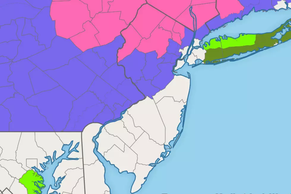
A Winter Storm Warning is in effect until 1 a.m. Tuesday for Morris, Sussex, and Warren counties. A Winter Storm Warning also covers western Bergan and Passaic counties until 7 a.m. Tuesday. A warning means significant winter weather (generally 6+ inches of snow) will make travel conditions downright dangerous. This is the most likely area for school closings on Monday (and possibly Tuesday too).
A Winter Weather Advisory has been posted until 1 a.m. Tuesday for Hunterdon, Mercer, Middlesex, and Somerset counties. A Winter Weather Advisory has also been issued for eastern Bergen, Essex, and Union counties until 7 a.m. Tuesday. An advisory is less severe and urgent than a warning, but advises of slippery travel conditions (generally 3+ inches of snow and/or light icing). In this area, there will probably be a mix of school closures and early dismissals for Monday. Delayed openings are possible for Tuesday too.
There are no advisories for southern or coastal New Jersey at this time, as the forecast does not reach the technical requirements for an advisory, watch, or warning. That is subject to change as the storm continues to develop.
Dan Zarrow is Chief Meteorologist for Townsquare Media New Jersey. Follow him on Facebook or Twitter for the latest forecast and realtime weather updates.
More From New Jersey 101.5 FM


