

Heavy snow bands for NJ Monday morning, gone by the afternoon
UPDATE as of 7:30 a.m. Monday...
Now that the storm's brunt is well underway, here are a few important updates:
--Temperatures are slightly colder and snowfall has been slightly heavier than expected. In addition, it seems pre-treatment and brining of roadways occurred too late (if at all). That has led to much snowier and icier road conditions than originally forecast, especially in North Jersey. Even major roads (I-80, I-78, I-287, Turnpike, Parkway) are sloppy.
--That heavy snow band along and just south of Interstate 78 is dumping snow out of the sky at a rate of 1-2" per hour. Snow totals in that area are already approaching 4 inches in spots. We may very well end up with a few 5s and 6s by the end of the storm.
--It's been a whole bunch of rain along the I-295 corridor this morning. The NWS has already shaved away the Winter Weather Advisory for Salem, Gloucester, and Camden counties. Still in effect from Burlington-Ocean on north.
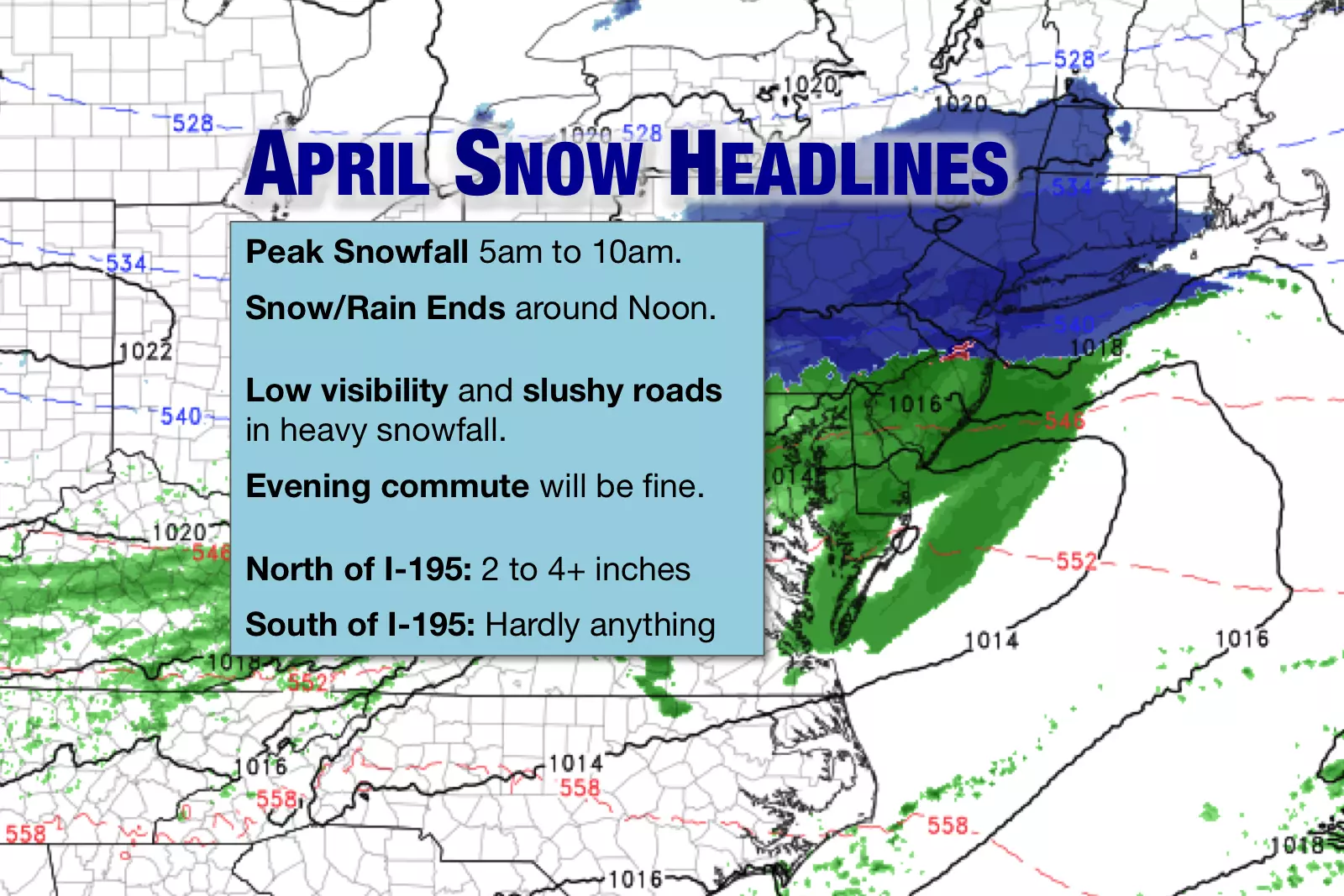
--Snowstorm timeline remains intact. Heaviest snow tapers by around 10 a.m. and ends completely around Noon.
ORIGINAL POST from 5:39 a.m. Monday...
Wintry
Our April snowstorm is underway! Throughout the weekend, I called this a compact, fast-moving system — a description that absolutely still rings true. Snowfall and rainfall arrived just after Midnight, and it will be done by Noon Monday.
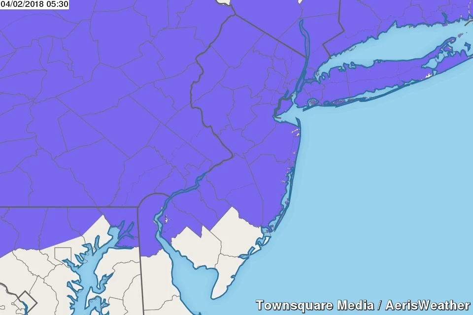
A Winter Weather Advisory continues for all but far South Jersey until midday Monday.
Heavy snow bands are expected to move through northern New Jersey between about 5 a.m. and 10 a.m. Some accumulation is expected — I'm still thinking 2 to 4+ inches north of I-195. For the southern part of the state, mixing and rain will limit accumulations to a coating at the most.
Roads will fare OK through the duration of this minor winter weather event, with most accumulation limited to colder non-paved surfaces. Those road surfaces are really warm after this weekend's burst of 60+ degree temperatures, so the snow is going to have a tough time accumulating there. (Not saying it's impossible, mind you.) For the most part, roadways (especially major and treated ones) should remain wet and slushy, rather than icy and snowy.
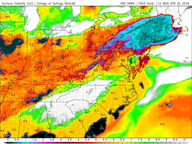
Therefore, I believe the biggest issue through the morning commute will be low visibility, dropping below a half-mile in the heaviest snow bands.
The most impactful snow is forecast to exit the Garden State around 10 a.m., with all precipitation ending around Noon. By this afternoon, we should get a few breaks of sun, a stiff breeze to 20 mph, and high temperatures in the lower to mid 40s. (Well above freezing, but well below early April norms.)
Skip the shovel if you can — most (if not all) of the snow will melt by Monday night.
In fact, as long as we maintain a partial blanket of clouds overnight, thermometers should stay above freezing across the vast majority of New Jersey. Lows are expected to dip mostly into the mid 30s by Tuesday morning. The refreeze, where melt water freezes to slippery solid ice, should not be a widespread issue.
Wet
Our active weather week continues Tuesday, with persistent scattered showers throughout the day. North Jersey looks particularly wet, with a few pockets of steadier, heavier rain possible. For the central and southern parts of the state, it's not going to rain all day, but might be pretty damp for a time. High temperatures should reach the upper 40s to lower 50s.
While there could be a bit of wintry mix in NW NJ at onset Tuesday morning, no significant icing is expected.
Latest models don't show any surface instability. While severe weather is not expected, a few rumbles of thunder are certainly possible on Tuesday.
Tuesday night, we'll see rising temperatures and probablly some fog.
That will set us up for a warm start to Wednesday, with widespread high temperatures in the 60s. It's not going to last long, as a cold front sweeps through the state around late morning Wednesday. That will drive through another brief round of rain and potential thunderstorms. Behind the front, we'll be treated to a brisk northwesterly wind with gusts to 40 mph. That will cause temperatures to nosedive by Wednesday evening.
Thursday looks like the best of the bunch of this weather forecast. The good news: It will be bright and sunny! The bad news: Thursday will also be a bit windy, with gusts to 30 mph. More good news: High temperatures will be in the lower 50s! More not so good news: That's actually about 5 degrees below normal for early April.
Wintry Again?
Models are painting another wet day for Friday, with periods of rain from early morning through late afternoon. Furthermore, as temperatures drop Friday evening, there will be a chance for a transition to snow. The potential is there for an inch or two of accumulation, perhaps. While much hype is already circling the internet about this system, daytime temperatures near 50 degrees will limit the snow potential (both during the day and at night too).
Dan Zarrow is Chief Meteorologist for Townsquare Media New Jersey. Follow him on Facebook or Twitter for the latest forecast and realtime weather updates.
More From New Jersey 101.5 FM


