
From rain and wind, to cold and snow: Active weather week for NJ
UPDATE... This article is outdated...
For the latest storm forecast information, please refer to my newest weather blog post.
UPDATE as of 4 p.m. Monday afternoon...
ORIGINAL POST from 6:57 a.m. Monday...
The Bottom Line
We have been so spoiled by quiet and mainly (albeit chilly) weather lately. That all comes crashing to an end, as a series of storm systems may impact New Jersey in the next week.
Yes, I used the word "may". There's still a great deal of uncertainty in this forecast, particularly surrounding the midweek storm. But it's getting close enough that it's time to start ringing some gentle alarm bells, so that you can plan accordingly, keep an eye on the ever-evolving forecast, and stay safe.
Monday's cold front passage will be a warm, wet, and windy surprise. The risk for severe weather and winter weather is very low.
However, Wednesday's outcome could be a bit more wintry. If the storm system veers close enough and if it's cold enough, New Jersey could see the first substantial snow accumulation of the season. But it does not look like a monster storm.
Monday: Storm System #1
—Morning rain showers... Spotty showers and patchy fog are wrapping up as of this writing (5:30 a.m.)
—Mild temperatures... High temperatures will average lower to mid 60s across the state Monday afternoon. Not quite record highs, but 10 to 15 degrees above normal.
—Quiet daytime weather... We should see some pops of sun through midday.
—Increasing wind... Through the afternoon hours, as we tap into a low-level jet, southerly gusts may hit 35 mph.

—More rain... A few hours of wet weather are possible starting around dinnertime Monday evening. A rumble of thunder is possible, although severe weather and flooding are not concerns. Total rainfall will be less than a quarter-inch.
—More wind... Behind a strong cold front, winds will flip Monday evening to blow out of the northwest. Still 35+ mph.
—Clearing and cooling... After midnight, raindrops will be done and wind will start to subside. Low temperatures will dip into the lower to mid 30s overnight. A frost is likely, a freeze is possible.
Tuesday: Quiet & Chilly
Tuesday will be at least 20 degrees colder than Monday, with high temperatures only in the lower 40s. Morning sun. Afternoon clouds. And maybe a few flurries along the way.
Wednesday: Storm System #2
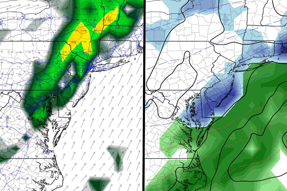
—Storm setup... A piece of energy will strengthen off the coast of the Carolinas, charging toward the northeast into the open ocean. It will develop a broad area of precipitation. Because NJ will be clearly on the cold side of the storm system, it is a potential snow-maker. But the breadth and position of the storm itself will have a huge effect on the precise weather impacts.
—An important word of caution... "Uncertainty" is a term you'll hear me use a lot during the winter season. It is an unfortunate truth that meteorology is an inexact science. It's an educated guess. And when it comes to snow forecasting, if that "guess" is off by a degree or two on the thermometer, or by a few miles on the storm track, it can turn into a total bust. That's why we have to play these things out very carefully and deliberately. Yes,there is a reasonable chance for accumulating snow coming up on Wednesday. But, to be crystal clear, it is not a monster storm, and it is not a slam dunk.
—Cold enough for all-snow? Probably. There had been some concern that the storm would wiggle to the northwest, closer to the coast, pushing in warmer air and forcing a transition to mix/rain along the coast. But I think the opposite storm track (farther out to sea) is more likely at this point.
—Close enough to NJ? There's the big question mark. While the American model suites (NAM and GFS) have been pretty bull-ish on snow potential, overseas guidance trends much less snowy and less impactful (European, Canadian, UKMET). The big difference is how close the center of this storm system tracks to the Jersey Shore. That's where the forecast uncertainty comes from. And that's why we have to consider possible outcomes ranging from "no snow" to "light snow".
—Enough moisture? Another concern. Cold air is dry air. And with dew points only in the 20s, the atmospheric column may not have the opportunity to really moisten up to fuel heavier precipitation. It's just another limiting factor, and another reason I'm confident in calling this storm "not major".
—Ground too warm? Sometimes a concern that limits snow from "sticking" in the early season. But I tend to ignore it unless it's really early in the season, since I've been burned by overthinking it before. Plus, I think we've had enough cold weather and Wednesday's air temperatures will be cold enough to sustain accumulation.

—Timeline... Daytime Wednesday seems to be primetime for any snowflakes to fall. If there is a "peak" to the snow activity, it would be around the midday hours.
—Temperatures... No matter what (if anything) falls from the sky, it's going to feel wintry and cold. High temperatures only in the mid 30s? That would be unseasonably cold even in the dead of winter (mid-late January).
—Highest-case scenario... An inch or two of snow accumulation. Possibly favoring the southern coast, closer to the storm's center. Possibly favoring colder northwestern New Jersey. (Yup, it could be a "South Jersey special".) It's really hard to get more specific than that at this point, unfortunately.
—Lowest-case scenario... A big fat nothing. Again, we're going to be on the western edge of the storm system. So if it veers even slightly out to sea, or ends up slightly more compact, we stay dry (although cloudy and cool).
—What happens next... Weather forecasting always works best when we handle one storm at a time. In addition, the forecast resolution for winter storm systems generally improves within 48 hours from first flakes. So please be patient — I know this outlook is We're planning to update this forecast late Monday and again early Tuesday morning. If Wednesday is going to turn even remotely messy, I promise you will be among the first to know.
Thursday & Beyond: Chilly
Thursday will be quiet, but still pretty cold, with high temperatures only in the lower 40s.
A weak wave passing through early Friday morning could produce a quick batch of precipitation. That may take the form of snow or wintry mix in North Jersey, with the potential for some light accumulations and/or slippery spots.
Temperatures are expected to moderate on Saturday, perhaps into the 60s. But another cold front Saturday night into Sunday morning will bring another cooldown. And possibly a rain-to-snow event. (Which we'll focus on more as it gets closer — a lot can change in 6-7 days.)
So, just like that, we're clearly back in "snow mode" here in the weather center. Thanks for following along as we traverse this treacherous season together. Only 15 days until Winter. 104 days until Spring.
Dan Zarrow is Chief Meteorologist for Townsquare Media New Jersey. Follow him on Facebook or Twitter for the latest forecast and realtime weather updates.
Favorite holiday movies from your childhood that will never get old
Gallery Credit: Kristen Accardi
LOOK: The top holiday toys from the year you were born
Gallery Credit: Jacob Osborn & Peter Richman
More From New Jersey 101.5 FM


