

Flood Watch: Another day of powerful summer thunderstorms for NJ
The combination of an approaching cold front, abundant ground-level moisture (humidity), and plentiful atmospheric energy (heat) will produce stormy weather across New Jersey starting Tuesday afternoon. Thunderstorms are expected to be widespread and will likely be on the strong side, with heavy downpours and gusty winds the primary concerns. Prime time for flooding rains and severe weather will be about 4 p.m. to Midnight. Rain may linger for a bit Wednesday morning, then our weather will clear nicely through the 4th of July holiday weekend.
Thunderstorm timing for NJ: Tuesday afternoon and evening
So far, Tuesday has been a warm summer day, with temperatures well into the 80s. And it has been very humid, with dew points well in the 70s. That soupy air is a very important factor in what is coming next, and why heavy rain takes the prize as our number one concern from Tuesday's thunderstorms. (More on that in a moment.)
Latest model guidance and radar trends show some isolated popup thunderstorms are already starting to pop this afternoon. Any storm that forms could reach strong to severe limits. But again, initial cells should be small and very hit-or-miss.

Prime time for thunderstorms and severe weather will begin after about 3 or 4 p.m. Tuesday. That is when a squall line of strong thunderstorms should crash into western New Jersey, progressing toward the coast through this evening. The most widespread storm activity over the state will unfortunately coincide with the evening commute (dinnertime) hours — probably peaking between 6 and 8 o'clock.

Once the sun sets, just after 8 p.m., storm stretch should slowly start to weaken. But that does not mean storms will disappear. Steady to heavy rain will continue driving through New Jersey into the evening hours. The severe weather threat will subside by Midnight, but rain chances may actually linger into part of Wednesday.
Thunderstorm impacts for NJ: Downpours and wind
We have a ton of ground-level moisture in play, an effect of Monday evening's thunderstorms and Tuesday's high humidity. That tropical air is going to fuel Tuesday's storms, leading to some heavy rain and significant flooding concerns.
I am confident in saying the heaviest rain will be located around southern and central New Jersey. While everyone in the state could see a half-inch to an inch of total rainfall, a localized streak of 2 and even 3 inches of rain is possible somewhere in that sweet spot.

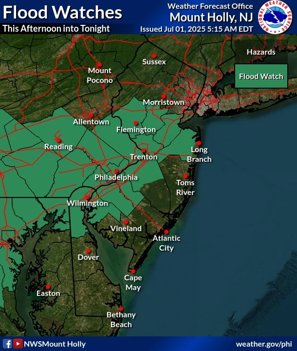
A Flood Watch has been issued for all or part of nine New Jersey counties, in effect from 2 p.m. Tuesday to 2 a.m. Wednesday for northwestern Burlington, Camden, Gloucester, Hunterdon, Mercer, Middlesex, inland Monmouth, Salem, and Somerset.
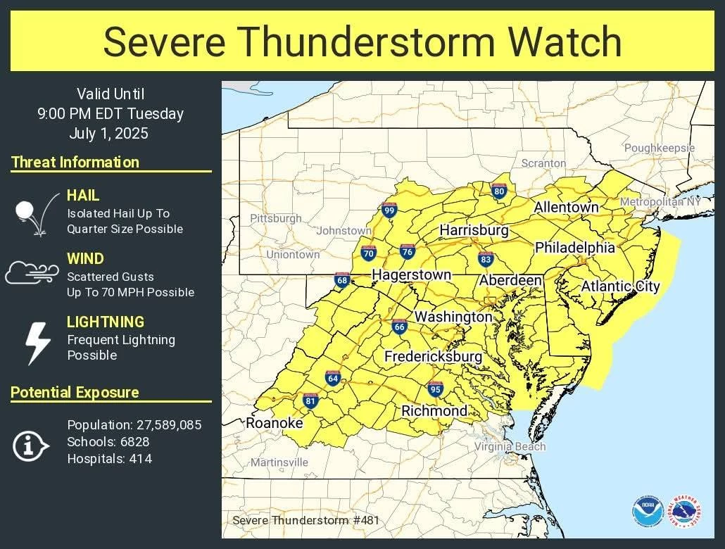
In addition to the heavy rain threat, strong thunderstorms may produce gusty winds in excess of 60 mph. That can cause tree and branch damage, sparking power outages. A Severe Thunderstorm Watch has also been issued for most of New Jersey — all but the northeastern corner of the state — until 9 p.m. Tuesday. A watch is simply a formal heads-up that dangerous weather may occur.
Dangerous cloud-to-ground lightning is always a danger from thunderstorms. As soon as you can hear thunder, you are close enough to be struck by lightning, so it is important to immediately seek shelter inside a sturdy building.
Hail and an isolated tornado are possible Tuesday too, although these are not our top concerns here.
Wednesday weather for NJ: Slow improvements
The latest forecast for Wednesday now shows rain lingering over New Jersey through the morning and midday hours, especially along the coast. Even through Noon or 2 p.m., it may remain dreary and damp in spots — quite a departure from the pleasant forecast we had been promoting just a couple days ago.
The aforementioned cold front will only knock back temperatures and humidity slightly. (Although the lingering raindrops and cloud cover will definitely hold temperatures at bay for Wednesday.) Once the sun pops out by mid Wednesday afternoon, thermometers should rise quickly into the lower 80s or so. (Remember my mantra: Any summer day in the 80s counts as "seasonable" or "near-normal" here in New Jersey.)
4th of July weather for NJ: Excellent
And then? Our weather turns incredibly pleasant, just in time for the big 4th of July holiday weekend. After so many weather difficulties over the past few months, from soggy washouts to horrendous heat, I am so happy we get to enjoy some great weather for fireworks, barbecues, the pool, the beach, etc.

I'm seeing upper 80s with sunshine on Thursday, and the slightest chance of a late evening shower. Mid 80s with sunshine for the 4th of July on Friday, likely with the lowest humidity levels of the week. Look for 80-ish on Saturday and a hotter 90-ish on Sunday, with dry weather continuing until about the middle of next week.

We will continue to keep you updated on the day-by-day forecast, of course. And don't forget to keep an eye on the Jersey Shore Report if your holiday weekend plans take you to the beach, bay, or ocean.
PHOTO GALLERY: June 20, 2025 Thunderstorms
Gallery Credit: Dan Alexander
Dan Zarrow is Chief Meteorologist for Townsquare Media New Jersey. Follow him on Facebook for the latest forecast and realtime weather updates.
11 reasons why storm chasing in NJ is a very, very bad idea
Gallery Credit: Dan Zarrow
More From New Jersey 101.5 FM


