Weather alert for NJ — Severe thunderstorms, gusty wind, heavy rain
🔴 A Severe Thunderstorm Watch is in effect for most of New Jersey
🔴 The worst of the storms will be late afternoon into the evening
🔴 Any tornado development should be weak
Central and South Jersey counties are facing the biggest threat of severe weather Monday with strong thunderstorms, gusty winds and localized flash flooding all a possibility.
Monday overall will be a sunny, hot and humid day with temperatures in the mid to upper 80s, according to New Jersey 101.5 Chief Meteorologist Dan Zarrow. Those elements will work to energize the atmosphere to produce strong potentially powerful storms along a squall line that develops ahead of the cold front.
Two tornado warnings were in effect in the 3 p.m. hour after radar picked up rotation in the clouds. The first was for parts of Warren County and Northampton County across the river in Pennsylvania until 3:30 p.m.
A second was issued for eastern Hunterdon County and northwestern Somerset County until 3:45 p.m.

Strong scattered thunderstorms already moved from southwest to northeast Monday morning prompting several short thuderstorm warnings.
Arrivals and departures at Newark Liberty has been hard hit by all the day's storms with hundreds of delayed and cancelled flights, according to FlightAware.com.
Flights into Newark were being held at their point of departure until 8:15 p.m.
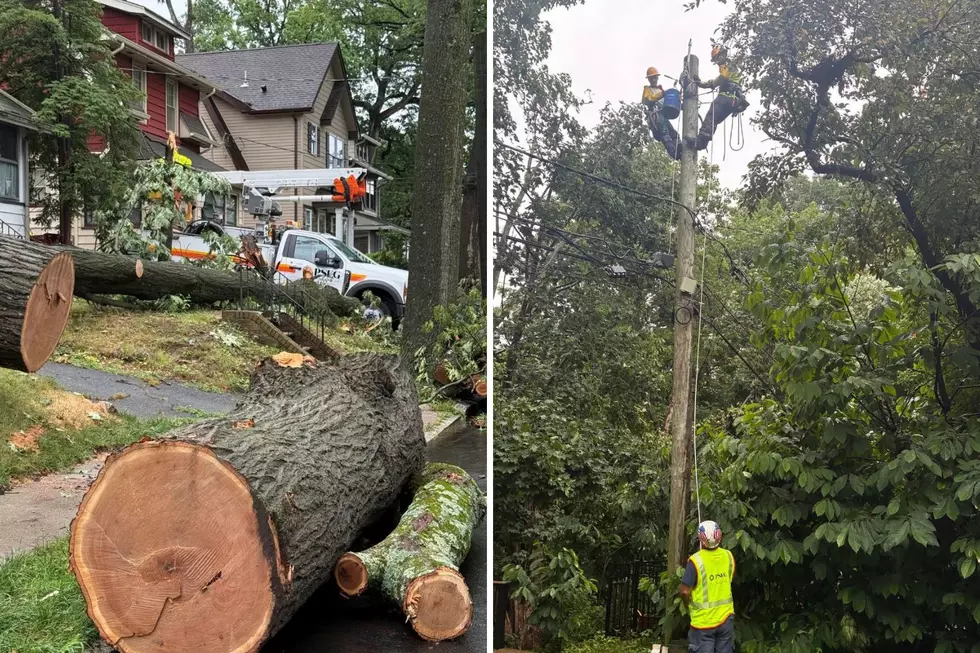
Over 17,000 JCP&L customers were without power as of 7:30 p.m. mostly in Hunterdon (Kingwood), Morris (Harding and Morris Townships), Somerset (Bernards, Bernardsville), Sussex (Stillwater) and Warren (Independence) counties, according to JCP&L's outage map.
PSE&G had nearly 500 outages scattered throughout its service area.
Stronger storms will develop in the afternoon as a around noon with the heaviest storms in the afternoon into the evening, according to Zarrow.
"Heavy rain is almost a guarantee from any storms on the order of an inch or two in a short period of time," Zarrow said.
The potential from the storms for New Jersey includes:
- Heavy rain which could drop an inch or two in a short period of time and 3-5 inches in some localized situations
- Possible large hail
- Isolated tornados
- Damaging 60+ mph winds

Worst of the storm
Zarrow said the worst nastiest weather will be along the western edge of the state as the storms push across the Delaware River.
"It's a matter of timing and temperatures," Zarrow said. "The later the main line of storms holds off, the hotter and more humid it will get."
There is a tornado threat, "although any spin-up should be brief and on the weak side."
Storms could have an impact on highways, NJ Transit bus and train services and airports.

Storms on Sunday
Storms that popped up on Sunday afternoon produced isolated area of heavy rain with flooding on Route 38 in Cherry Hill, Route 22 in Bound Brook and Route 30 in Lindenwold, according to National Weather Service reports. Pea-size hail was reported in Atco and Berlin while trees were brought down in Clementon and Gibbsboro.
A man using a power tool in the garage of his home in Cranford was struck by lightning Sunday afternoon, Cranford police told ABC 7 Eyewitness News. The tool became charged with a surge in current and electrocuted the man, although not fatally.

Report a correction 👈 | 👉 Contact our newsroom
LOOK: Famous actors from New Jersey
Gallery Credit: Stacker
LOOK: Most commonly seen birds in New Jersey
Gallery Credit: Stacker
How to pronounce these 20 town names in NJ
Gallery Credit: Judi Franco
More From New Jersey 101.5 FM