Strong storms and record warmth expected across NJ Wednesday
2:50 p.m. - Severe Thunderstorm Warning until 3:45 p.m. for SW Atlantic County and all of Cape May and Cumberland counties for a severe line of storms with 70 mph winds amd penny size hail.
1:36 p.m.: Thunderstorm Watch in effect until 7 p.m for Atlantic, Burlington, Camden, Cape May, Cumberland, Gloucester, Hunterdon, Mercer, Middlesex, Monmouth, Ocean, Salem and Somerset counties.
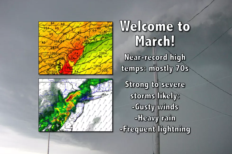
Fueled by 70+ degree temperatures, thunderstorms could produce damaging winds, very heavy rain, and lightning for the Garden State.
Here are your weather headlines for this very active Wednesday, March 1, 2017...
Welcome to March!
We did it, New Jersey! We made it to March! Wednesday marks the first day of "climatological Spring" — we use full calendar months to calculate seasonal statistics in the meteorology and climatology world, as it just makes the math easier. The Vernal Equinox, the official start of Spring, will occur on March 20 at 6:29 a.m. EDT (according to Almanac.com).
February 2017 will go down as New Jersey's warmest February on record. And that warmth will continue for the first day of March. But not for the second day of March through the first weekend of March.
Near-Record Warmth
Temperatures are starting in the upper 50s Wednesday morning. Even though skies will range from mostly cloudy to overcast, even though the Jersey Shore may hold on to some persistent fog all day, high temperatures should soar into the upper 60s to (mostly) lower 70s. Record high temperatures for Wednesday are 75 at Newark, 74 at Trenton, and 72 at Atlantic City. (All three records date back to March 1, 1972.)
Even more impressive, it's going to get pretty humid by Wednesday afternoon. The dew point — a measure of moisture in the atmosphere, defined as the temperature at which condensation (dew) would form — will rise from the 50s to the 60s. It might be the first time we've seen 60s on the hygrometer in 2017. It certainly won't be the last.
That unseasonable warmth and rich atmospheric moisture will combine with an approaching cold front to fuel some rain and thunderstorms. Those storms are likely to grow to strong/severe limits, making for a loud and potentially dangerous early March day.
Storm Timeline
We're actually expecting two rounds of rain during the day Wednesday. The first will arrive between about 9 a.m. and Noon. Models show a period of moderate to heavy rain, mainly for central and then northern New Jersey.
Wednesday's second round of rain will be the one to watch, as the timing will approximately coincide with both the day's peak heating and the approaching cold front. That timing will also unfortunately coincide with Wednesday evening's rush hour.
Best sense of timing for the worst storms looks to be 2 p.m. to 7 p.m. The setup will be similar to this past Saturday, with a line of powerful storms sweeping from west to east across the state. Once again, for any given location, the nasty weather will be brief but potent.
Lingering showers and thunderstorms will remain possible through Wednesday night, until cooler and drier air arrives behind the frontal passage.
Storm Impacts
The Storm Prediction Center has placed New Jersey in a "Slight Risk" for Wednesday, the 2nd highest of 5 severe threat categories. Here are my concerns with Wednesday afternoon's round of thunderstorms, listed from most precarious to least:
--Gusty Winds: Squall lines are most notable for pushing a lot of air ahead of the rain, producing potentially damaging "straight-line" winds. A strong low-level jet (strong winds just above the surface) signal the wind will be among our greatest threats for Wednesday. Gusts over 40 mph are likely. Gusts over 60 mph will be possible.
--Torrential Downpours: I already mentioned our incredibly humid atmosphere, which will obviously play into the intensity of the rain. Visibility and traction will be problems in the heaviest rain. Flash flooding of low-lying areas will be possible.
--Frequent Lightning: By definition, every thunderstorm is dangerous due to the threat of cloud-to-ground lightning.
--Hail: There were reports of small hail from Saturday's storm (including in my backyard), and I suspect the same would be true for Wednesday's storms.
--Isolated Tornadoes: I fully recognize that your heart probably skips a beat when you see that "T" word in a forecast. But because the tornado parameters are marginal, the chance for a quick spin-up somewhere in New Jersey is not zero. (I'm also reminded by the confirmed EF-2 tornado near Scranton, Pennsylvania over the weekend.) I just don't want any nasty, unexpected surprises here. The best chance for tornadic storms will be in the (warmer) southern half of the state.
Limiting Factors
There are a few things that could limit the intensity of our impending thunderstorms:
--Cooler Temps: If temperatures do not reach the 70s, the atmosphere won't have as much "bang" to form and sustain such strong thunderstorms. Therefore, the cooler Wednesday's high temperatures, the lower our threat for severe weather will be.
--Timing: Similarly, if the line of storms arrives later — after temperatures begin to cool Wednesday afternoon — the potential energy for those storms will be lower. The GFS model supports this later timeline and lower severe weather threat.
The Big Cooldown
Behind the storms, colder and drier air will return to New Jersey, enacting a cooling trend through the first weekend of March. Temperatures will fall to the upper 30s to lower 40s by mid-morning Thursday. A gusty wind, over 30 mph at times, will ensure that you fully feel that chilly air.
Skies will be bright and sunny by late morning Thursday. Winds will remain brisk and temperatures will be limited to the mid to upper 40s by Thursday afternoon.
Really? Snow?
By Friday morning, temperatures will bottom out below freezing for the vast majority of New Jersey. (The only exception will be the southern coast.) Meanwhile, a clipper system will swing across New Jersey at some point on Friday, providing a chance for rain and snow showers.
The precipitation that falls on Friday will be light. I don't want to rule out some light accumulation, mainly north of Interstate 78 and especially among the higher elevations. I maintain an outside chance of an inch or two on the ground somewhere in New Jersey. However, our above-freezing surface temperatures, very warm ground, and the overall light intensity of the snowfall will severely limit the accumulation potential.
Colder, Coldest, Warm, Warmer
Friday's high temperatures will be limited to the upper 30s to mid 40s. That's right around or just below normal for early March.
It looks like temperatures will bottom out on Saturday. Despite mostly sunny skies, highs will only make it to the mid 30s at best. A brisk wind will keep the day feeling blustery too.
Thermometers should recover to the 40s on Sunday, again with a stiff breeze and plentiful sunshine.
And we'll be back in the 50s by early next week.
More From New Jersey 101.5 FM


