

NJ’s weather turning more unsettled through this weekend
The Bottom Line
After a couple of spectacularly sunny days, it is time for changes in New Jersey's weather world. Both clouds and humidity will be on the rise Wednesday. We will squeeze out one more reasonably pleasant almost completely dry day. (Aside from a sprinkle.) Then our weather turns even more unsettled.
I use that term a lot in my forecasts: Unsettled. I take it to mean increased cloud cover and hit-or-miss shower chances. There is also a connotation of "uncertainty" in the word, as situations like this make it nearly impossible to pinpoint raindrop timing, geography, etc.
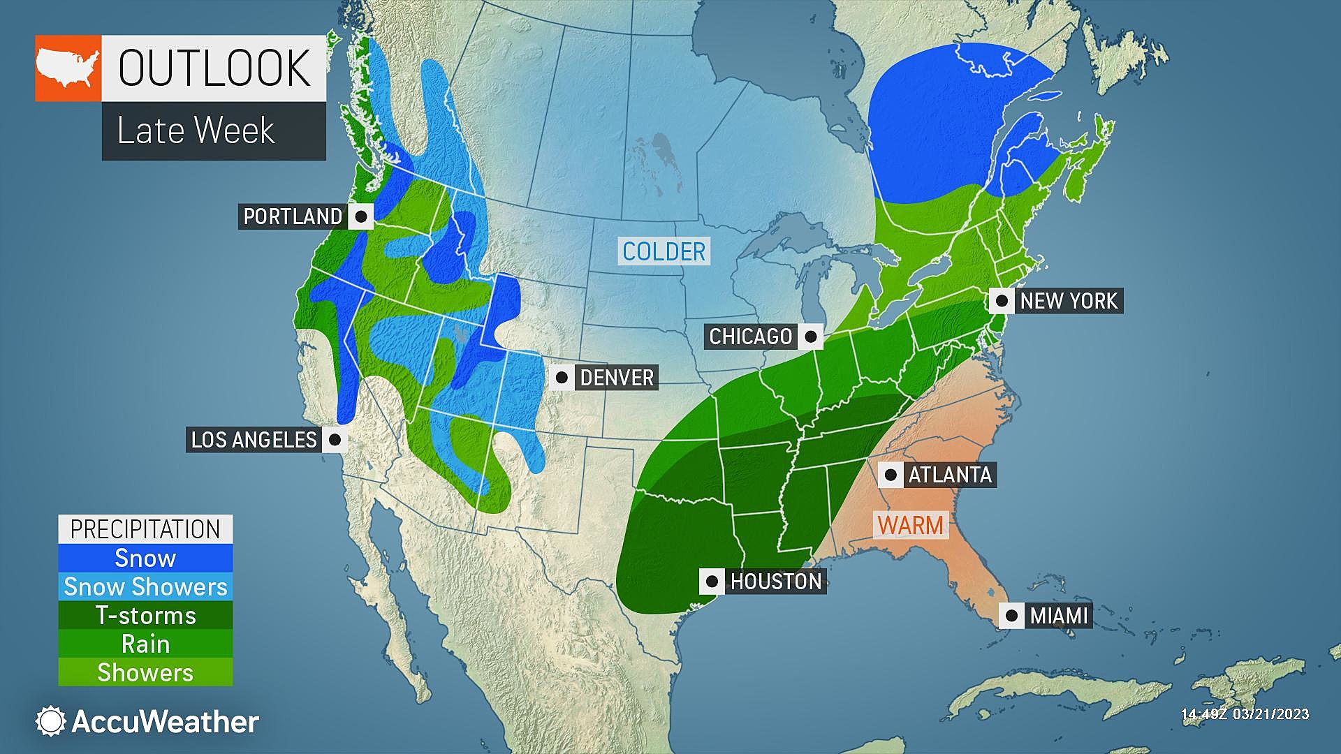
A stalled frontal boundary will be a royal pain in the neck later this week, keeping "unsettled" weather over New Jersey through the rest of the week. The wettest day of the bunch actually looks to be Saturday. Our next shot at a truly "nice" day will be Sunday.
Also, it needs to be said — there are no significant wintry weather threats in the forecast. At the same time, we are not quite in the "sustained warmth" phase of spring just yet either.

Wednesday
Overall, not bad.
We are starting Wednesday morning with most spots above the freezing mark, averaging upper 30s. It's still cool enough to need a jacket to start the day.
Highs Wednesday afternoon will reach about 60 degrees. Ever so slightly cooler than Tuesday, thanks to partly to mostly cloudy skies. Winds will stay light. Dew points will climb from the teens into the 40s — it won't feel humid necessarily, but your skin and lips should feel less chapped.
Radar does show a batch of very light showers moving from Ohio to Pennsylvania. I think any raindrops over New Jersey will be few and far between, struggling to reach the ground before evaporating. But I am including a chance of sprinkles in the forecast, mainly along the Jersey Shore.
Wednesday evening looks quiet. And it will not be as cold as the past several nights. We will bottom out in the mid 40s, on average, under a blanket of clouds.
Thursday
Rain chances go up on Thursday. And odds are pretty good that you'll get wet at some point. But it will not be an all day thing.
A few spotty showers are likely to form Thursday. And there may be enough energy in the atmosphere to sustain a little downpour or thunderstorm. In such a case, rainfall totals may exceed a quarter-inch.
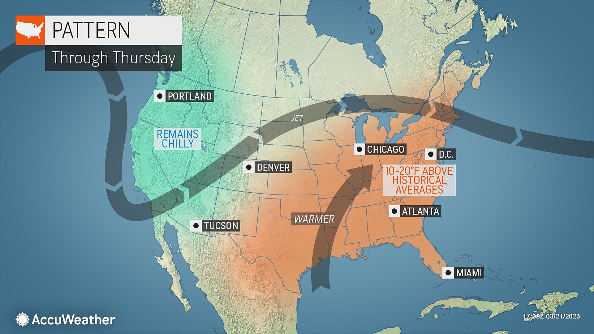
When it's not raining — which will be the case for most of Thursday — skies will be mostly cloudy, and we'll catch a noticeable southwesterly breeze. That will push temperatures back into the lower to mid 60s Thursday afternoon. Still well above normal for late March.
Friday
Friday's forecast is tricky. We will be under the influence of a cold front, arriving early morning and likely stalling right over the state.
There is a chance of rain showers on Friday, but it's not necessarily a "whole state" kind of thing. Again, this is a classic "unsettled" weather pattern, which makes pinpoint details very difficult.
Forecast models trend toward falling temperatures on Friday. Early morning near 60 will probably turn to 40s by the afternoon.
Overall, Friday doesn't look like a "pleasant" day necessarily. But not a washout or total loss for anyone in New Jersey.
Saturday
One last impulse in this series is forecast to arrive on Saturday. And it may lead to the steadiest rain of the bunch.
Again, it's all about the location and orientation of that stalled boundary. I think there is a reasonable chance that part of New Jersey sees an overall rainy day on Saturday. Possibly over an inch of rain, if everything lines up perfectly.
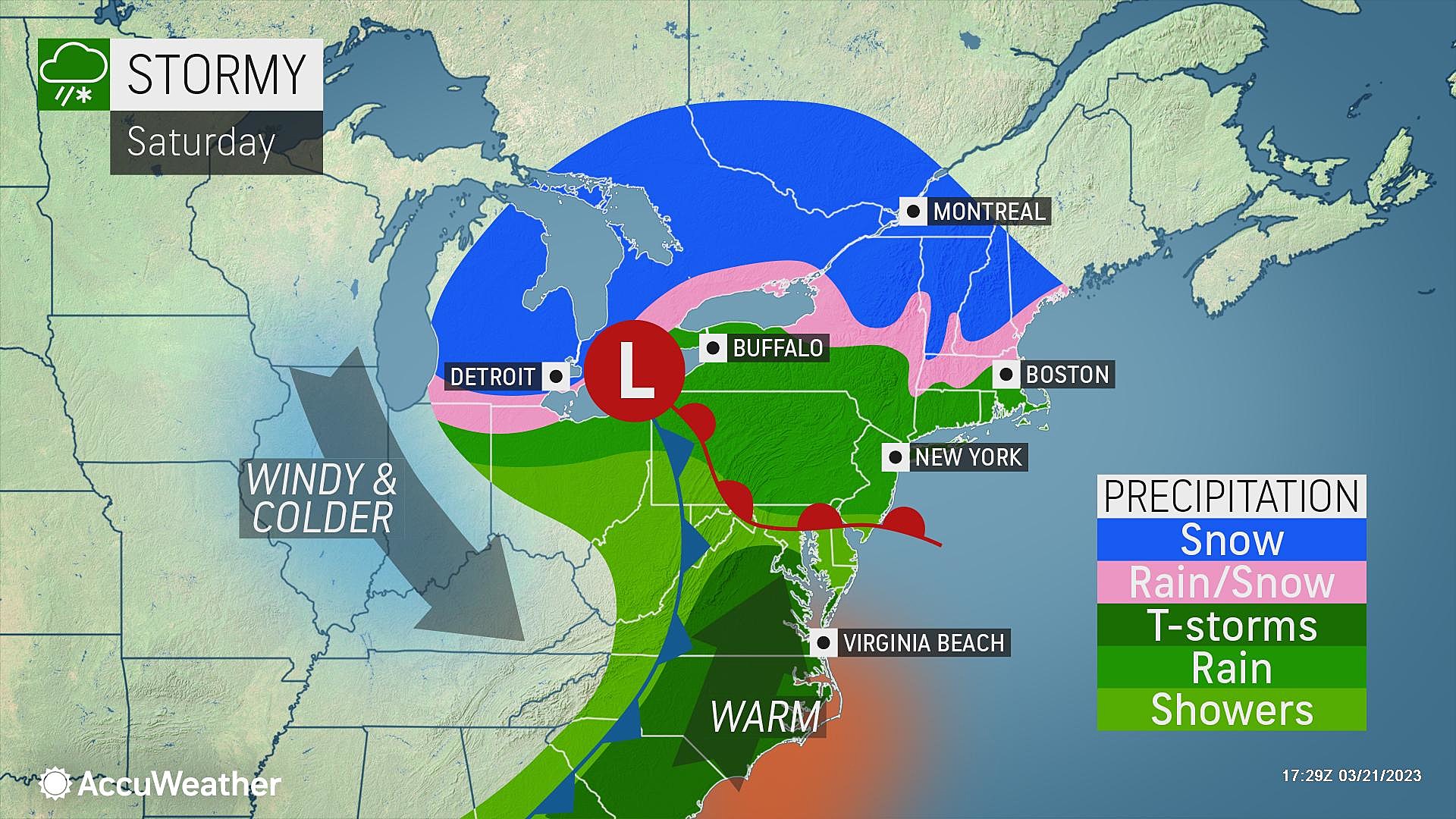
So again, not a great weather day. I would keep outdoor plans flexible. High temperatures will probably end up somewhere in the 50s.
Sunday & Beyond
Sunday will easily be the better, brighter day of the weekend. Although you will have to deal with a brisk wind blowing out of the west. Hopefully high temperatures will pop back into the 60s to make up for it.
Another storm system is set to roll in Monday, with an extended batch of showers. With cooler air nearby, there is a chance for some wintry mix along the northern edge of New Jersey. But I'm still thinking any accumulations and travel impacts would be very limited.
Next week will be seasonable, with temperatures mainly in the 50s. It might be a while before we see a long period of non-freezes and 60s/70s in the afternoon. But we'll get there eventually. Spring has sprung, after all.
The CMDZ weather blog will take a hiatus, as I enjoy a mini-vacation for a few days. Unless something big and surprising breaks, I'll be back with you next week.
Dan Zarrow is Chief Meteorologist for Townsquare Media New Jersey. Follow him on Facebook or Twitter for the latest forecast and realtime weather updates.
The Most Underrated Disney Movies Of The Last 25 Years
Is Disney's 'Cafe May Cafe' a real taste of New Jersey?
Gallery Credit: Dan Zarrow
More From New Jersey 101.5 FM


