

NJ’s next round of strong-severe summer storms coming Thursday night
TORNADO WATCH in effect until 10 p.m. for Atlantic, Burlington, Camden, Cape May, Cumberland, Gloucester, Ocean and Salem counties until 10 p.m. Thunderstorms late Thursday afternoon into the evening could be severe with damaging winds and very heavy rainfall which could result in localized flash flooding.
Thursday will be hot, with high temperatures near 90 degrees. Thursday will be humid, with dew points near 70. And then Thursday will turn stormy, with the arrival of a strong cold front. Heat (energy) plus humidity (moisture) plus lift (spark) equals thunderstorms — the magical equation of our atmosphere.
Since Thursday's storms could get rather loud, and even dangerous, I have prepared this rundown of what to expect:
—When? The daytime hours look quiet, although I wouldn't rule out a popup shower or thunderstorm. The best chance of widespread thunderstorms in New Jersey will be between about 5 p.m. Thursday and 1 a.m. Friday.
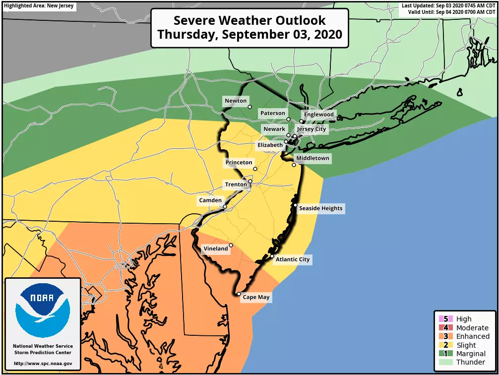
—Where? I agree very much with the Storm Prediction Center's severe weather outlook for Thursday, painting SW NJ as the most likely place for severe (even tornadic) thunderstorms. However, don't focus too much on that geography. All but far North Jersey are under the gun for heavy rain and frequent lightning, at the very least. It's just that the farther south you are, the more charged the atmosphere will be and therefore the bigger the wind, rain, and tornado threat.
—What? It's hard to tell whether our biggest problem from Thursday night's storms will be rain or wind. Localized 3+ inches of rain? 60+ mph wind gusts? Flash flooding, downed trees, and sporadic power outages will be real concerns here. In addition, lightning is a potentially dangerous factor in every thunderstorm — and given Thursday's heat and humidity, the air will be quite electric. Hail is a good possibility in the strongest storm cells. And there is a 5% tornado risk painted for NJ too. While I believe the greatest risk of a rotating storm will be just to our southwest, we'll still have to watch the skies carefully over southern and central New Jersey Thursday evening.
—Who Cares? We only use this kind of language when the atmosphere become truly explosive. CAPE — that's Convective Available Potential Energy — could reach 1500 to 2000 J/kg in SW NJ. That's pretty healthy for the Northeast U.S. Of particular concern is the threat for cellular or supercellular (rotating) storms. In contrast to other convective modes (such as squall lines, mesoscale convective complexes, etc.) supercells can grow rapidly and become pretty scary in a hurry, producing a nasty mix of rain and wind and hail and tornadoes. While not everyone in New Jersey will see one of these severe storms, with radii of only a few miles — the threat potential is high enough to ring the alarm bells here.
—What to Do? This is one of those days (well, nights) to stay "weather aware" — you know about the timing and geography of the storm risk, now stay alert to changing conditions and keep a lookout for watches and warnings to be issued. The best place to be during any thunderstorm is inside a sturdy building. If wind or tornadoes are predicted, you'll want to go to the center part of the lowest level of that sturdy building, keeping away from windows.
—What's Next? The aforementioned cold front will open the door to much drier air, just in time for the big Labor Day Weekend. Low humidity, sunshine, dry weather, and warm temperatures near 80 degrees? Wow! Our next rain chance may not come along until the middle of next week.
That's all for now. Stay smart and be safe this evening. I am still on vacation through next week, but our entire team is on standby to keep you informed about these thunderstorms and more.
Dan Zarrow is Chief Meteorologist for Townsquare Media New Jersey. Follow him on Facebook or Twitter for the latest forecast and realtime weather updates.
More From New Jersey 101.5 FM


