

NJ winter weather update, part 2: More snow coming Thursday night
UPDATE... This article is outdated...
For the latest winter storm forecast information, please refer to my newest weather blog post.
UPDATE as of 4:15 p.m. Wednesday...
UPDATE as of 3:30 p.m. Wednesday...
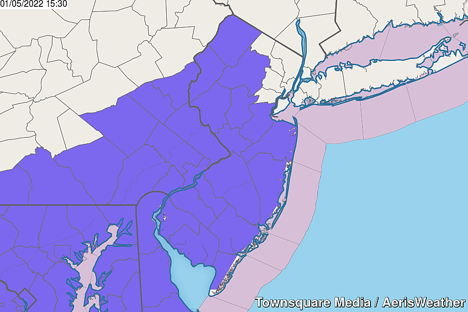
With about 31 hours to go until first flakes, the National Weather Service has issued a Winter Weather Advisory for most of New Jersey for tomorrow night's snow event. It runs from 10pm Thursday to 10am Friday. And, for now, does not include the immediate coast nor northeastern New Jersey.
I think the timing and choice of advisory rather than watch/warning is spot on. I'm still thinking "3 inches, give or take" is the most reasonable snow total forecast for this storm.
ORIGINAL POST from 7:54 a.m. Wednesday...
The Bottom Line
This is my second weather blog update of the morning — whew! We are dealing with widespread icing issues Wednesday morning, as spotty freezing rain passes through New Jersey.
For more details on that piece of the forecast, please click here.
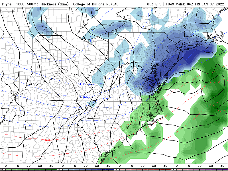
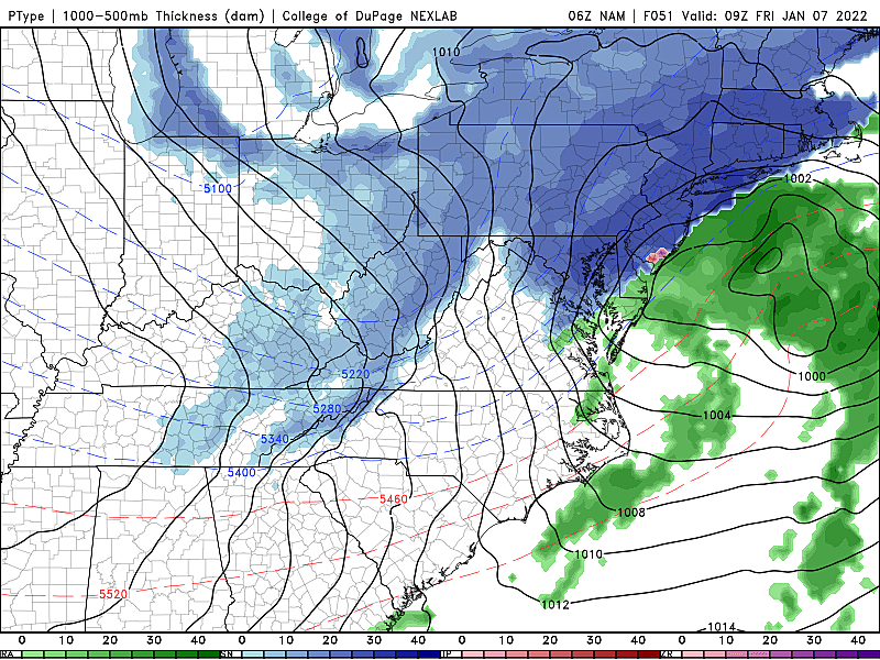
The next winter storm down the road is set to arrive late Thursday night. It will be fast-moving and relatively compact. I guess you could call it a coastal storm, a nor'easter, if you want — but the inland piece of energy is not going to "phase" properly with the off-shore low. Bottom line I'm not expecting a "blockbuster" snow event here in New Jersey.
Having said that, Thursday night's storm system is forecast to dump multiple inches of snow over New Jersey. I am particularly concerned about traffic getting snarled for Friday morning's commute.

Timeline
Snow is likely across the entire state from late Thursday night through Friday morning's rush.
—Start... 10 p.m. Thursday
—End... 8 a.m. Friday
Note: There is no well-defined "peak" or "brunt" of the storm, a period of particularly heavy precipitation. The overnight to early morning hours all look equally snowy for now.
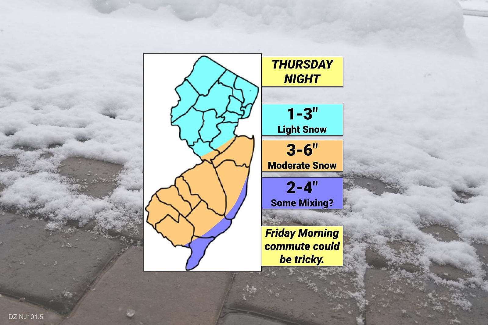
Totals
Given timing and temperatures, this is expected to be an "all snow" event for the majority of New Jersey.
Generally, the magic number here seems to be 3, give or take. Approximately 3 inches of fresh accumulation, which is the bottom end of "moderate" or "advisory-level" snowfall.
Digging into that further, here's how I broke down my first stab forecast:
—The Sweet Spot... The combination of heaviest snow bands, below-freezing temperatures, and richest moisture will result in the most snow across central and inland southern New Jersey. On the order of 3 to 6 inches.
—North and West... Still somewhat snowy. But far away from the center of the storm system, snowfall intensity will be lighter than farther south. I think an inch or two seems most likely — once again, North Jersey will not see the most snow in the state from this storm!
—South Coast... The center of this storm system will carry some warmer air. Warm enough to force a transition from straight snow to mix or even plain rain. If the center tracks close to the Jersey Shore, snow totals would be effectively cut off when such mixing occurs. That's why I've kept snow totals for shore points (with a southern exposure) slightly lower. For now. We'll see how things continue to develop.
What If the Storm "Wiggles" Closer?
As always, we have to consider how the storm and its forecast could evolve before first flakes arrive in 36 to 48 hours.
In this case, a subtle shift to the north/west would be a double-edged sword. On the one hand, the heaviest snow bands would push farther north in New Jersey. (Beyond the NJ Turnpike corridor.) I could even see some 6+ inch totals developing somewhere in New Jersey, especially if the snow ratio is just right. I still don't think North Jersey would tap into any degree of "heavy" snow.
On the other hand, the storm's center would inch closer to the NJ coast. That means mixing/rain would be even more likely, forcing accumulations even lower. (An inch or two, perhaps?)
What If the Storm "Wiggles" Farther Away?
In this case, the heaviest precipitation would shift away from New Jersey. But we'd still be on "the cold side" of the storm. So we'd still see some accumulating snow, even along the immediate coast.
But totals would end up a full category lower. 3 to 6 inches? Swings to 1 to 3. 1 to 3 inches? Eh, try 0 to 1.
Impacts / Action Steps
I've called the impacts from this winter storm "moderate". Most of the snow will fall and accumulate during the overnight hours, limiting traffic incidents and the threat of people getting stranded due to deteriorating weather.
However, I am very concerned about a snowy, icy Friday morning ride to work/school. I sense delays, closings, and virtual days are ahead if the wintry forecast verifies.
The National Weather Service will likely start issuing advisories late Wednesday or early Thursday, as the forecast continues to firm up. That will be your signal to get ready for the storm. Check your plans and supplies, and be ready for a period of inclement weather.
Again, it's not a major, blockbuster, historic storm — but you should be prepared, regardless. Especially since this will be the first accumulating snow of the season for all but far northern and southern New Jersey.
What's Next?
Friday afternoon will turn sunny and blustery, with highs in the 30s.
No problems for Saturday, as sunshine and unseasonably cold temperatures continue.
Our next next next storm system in line is set to arrive Sunday morning. And it will be with us through early Monday morning.
It's a slow-moving cold front, which will produce mainly rain over New Jersey. However, there is a reasonable possibility that we see an initial transition from wintry mix to rain at onset Sunday morning. And/or a flip back to snow late in the storm Monday morning, as colder air returns.
It looks like we'll get to catch our meteorological breath a bit next week. High pressure will mean quiet, although cold weather for Monday and beyond.
Dan Zarrow is Chief Meteorologist for Townsquare Media New Jersey. Follow him on Facebook or Twitter for the latest forecast and realtime weather updates.
Counting down New Jersey's top 15 weather stories of 2021
Gallery Credit: Dan Zarrow
50 Most Popular Chain Restaurants in America
Gallery Credit: Paul Feinstein
More From New Jersey 101.5 FM


