
NJ weather: Watching one ‘lion-ish’ late-week storm system
The Bottom Line
Happy March 1st! The start of climatological spring, this is a "middle of the road" month for New Jersey. On average, it is our 4th coolest, 5th wettest, and 4th snowiest month of the year. March is notorious for being a violent month for weather — hence the adage that it roars in like a lion, but out like a lamb.
The first day or two of the month will be lamb-ish, with just some fog, frost, and shower concerns.
Then our next storm system arrives on Friday. That one is trending warmer and later. Yes, the forecast calls for a return of inclement, nasty weather and limited snow/ice accumulations. But it will not be an all-wintry situation.

Wednesday
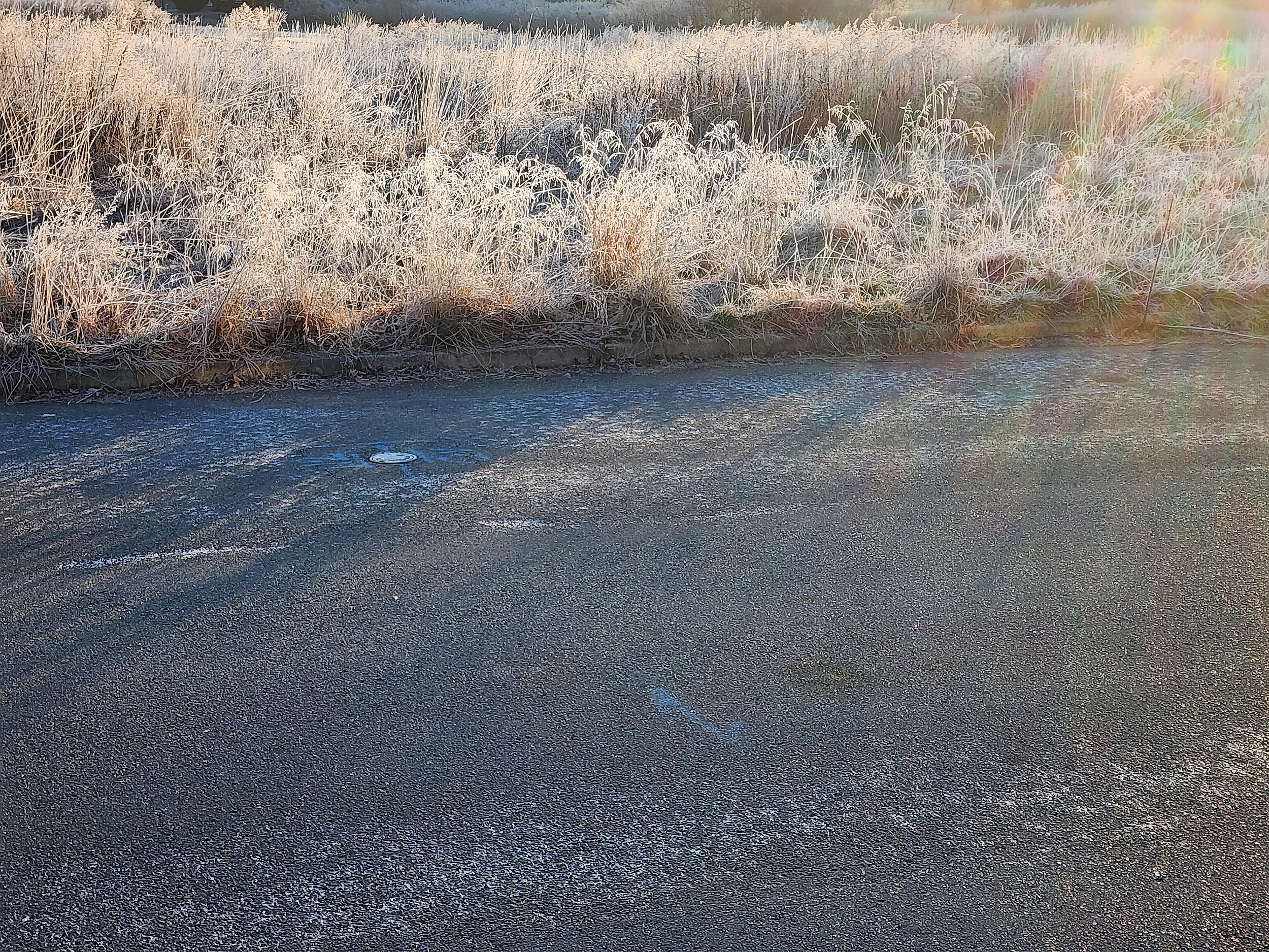
Watch your step! With temperatures in the 20s and 30s Wednesday morning — mainly below freezing — there are two reasons for icy spots. First, the refreeze — wet surface may have turned back to ice overnight. Second, freezing fog — which may also lead to pockets of reduced visibility.
By about 9 a.m., both the slippery spots and patchy fog should be gone. And the rest of your Wednesday looks pretty good. Partly sunny skies. High temperatures will range from about 40 degrees in North Jersey to near 50 in South Jersey.
A shower may clip North Jersey around the late afternoon hours. Just a quick hit or raindrops or even snowflakes. No big deal.
Wednesday night will feature increasing clouds, increasing temperatures, and increasing fog. As thermometers dip to around the 40 degree mark, close to the (rising) dewpoint, I am concerned about widespread pea soup low visibility by Thursday morning.
Thursday
Thursday will start with not only fog, but also a quick batch of showers. They'll be scattered, fairly hit or miss. And almost totally rain, although I can't rule out some mixing with snowflakes along the northern edge of NJ only.
Thursday afternoon will be OK. Cloudier, windier, and warmer than Wednesday, with highs between 50 and 60 (north to south). A northwesterly wind may gust to 30 mph into Thursday night, as colder air works back into New Jersey.
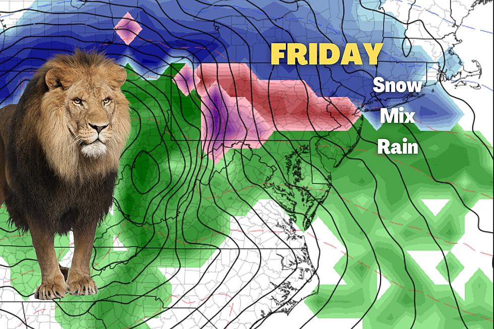
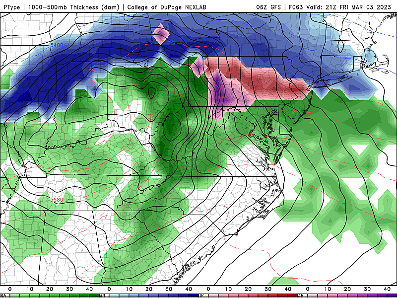
Friday
Friday's forecast is still complicated. At the very least, turning inclement. Even downright nasty. And a touch wintry. But yet again, temperatures are not quite cold enough to call this a true "winter storm" for New Jersey.
As I mentioned, this one is trending notably 1.) warmer, and 2.) later. Here is how I see this one playing out — keeping in mind we still have about 60 hours to go until first drops/flakes.
Things will get started early Friday afternoon. Initial precipitation type will probably be snow in North Jersey, wintry mix in Central Jersey, and rain in South Jersey. The brunt of the storm, with the heaviest and most widespread precipitation, will come Friday night through early Saturday morning. Meanwhile, warming temperatures will force a transition to wintry mix in North Jersey, and rain from Central to South Jersey. The storm system will really start to wind down around daybreak Saturday morning.
I'm not quite comfortable drawing a detailed snow map just yet. I think we could see a few inches of snow/sleet accumulation along the northern edge of the state. Maybe on the order of 3" or 4". That is enough for some travel headaches. A trace of snow or ice could reach as far south as I-195 again, in a perfect setup. Total rainfall will likely exceed an inch for many. Top wind gusts will be between 30 and 40 mph.
Again, inclement, nasty, and a touch wintry. That's it.
Saturday
Not a great day. Cloudy skies hang on, with snow and rain showers (more like drizzle and flurries) lingering too. Once again, we'll see a big high temperature range. From the chilly mid 30s among the fresh snow cover of far northern New Jersey, to around 50 in bare-ground southern NJ.
Sunday & Beyond
I believe Sunday will be the nicer day of the weekend, as our weather dries out, skies brighten, and temperatures settle around 45 to 50 degrees.
Beyond that, the forecast gets really hazy next week. I think it will be generally cold and dry through the second week of March. (The one exception is a batch of showers on Tuesday.) High temperatures will probably end up primarily in the 40s. We are getting to the time of year when that is below-normal. The first day of Spring is just 19 days away.
Dan Zarrow is Chief Meteorologist for Townsquare Media New Jersey. Follow him on Facebook or Twitter for the latest forecast and realtime weather updates.
8 Exciting New Things at Hurricane Harbor for the 2023 Season
2023 Seaside Heights Polar Bear Plunge
More From New Jersey 101.5 FM


