

NJ weather: Latest update on this soggy, stormy weekend
The Bottom Line
Two storm systems. Two extended periods of much-needed rain. One crummy weekend.
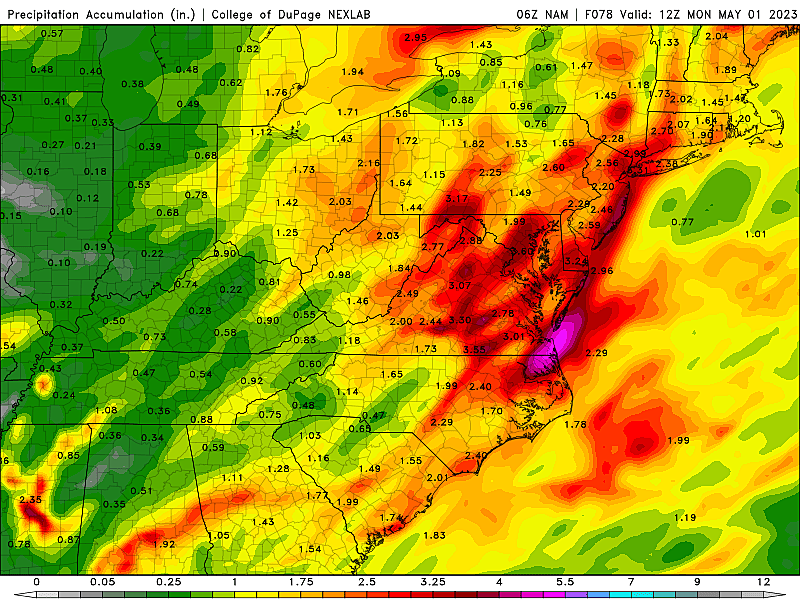
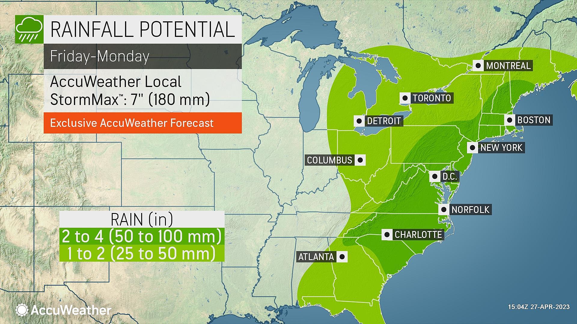
Your plans for Friday, Saturday, and Sunday may very well be affected by this rainy, potentially stormy weather. It's not quite a total washout, but more hours will be wet than dry between now and Sunday night. 1 to 3+ inches of total rainfall are expected.
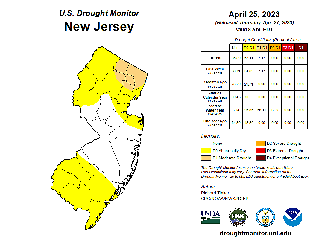
Of course, let me remind you how badly we need a good soaking. The latest U.S. Drought Monitor puts 7% of the state (to the northeast) in Moderate Drought, with a total of 63% of NJ classified as Abnormally Dry.
Although the threat for truly "severe" weather is limited this weekend, we could see some embedded thunderstorms, heavy downpours, and/or gusty winds around New Jersey. In this article, I want to provide a quick, easy-to-skim overview of when it will rain, when it will storm, and when it won't.

Timeline
—Friday Morning... While the day starts dry, rain showers will arrive, from southeast to northwest, between 8 a.m. and Noon.
—Friday Afternoon... Consistent, steady rain envelops New Jersey. It will likely be breezy to windy too.
—Friday Night... More of the same. Wet. Rain could be heavy at times.
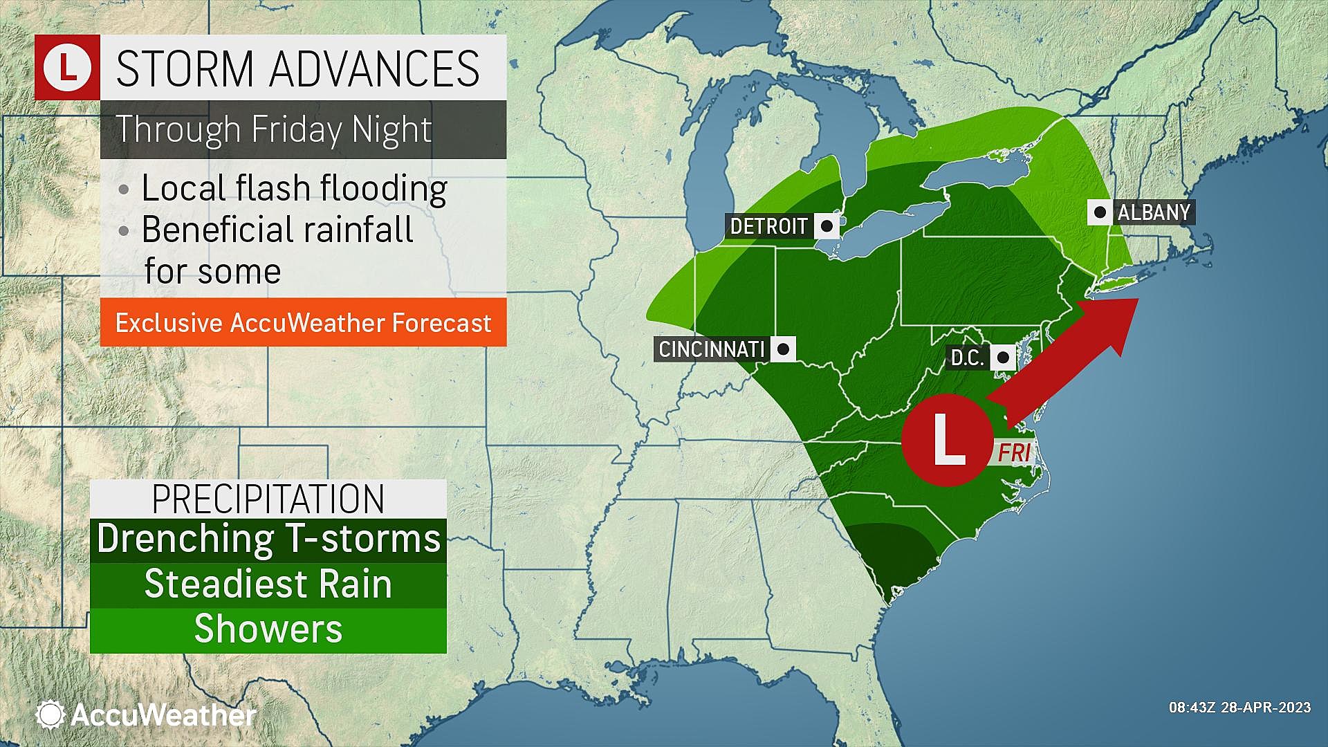
—Saturday Morning... Rain and wind could get heavier for a time, with rumbles of thunder.
—Saturday Afternoon... First storm system exits. Southern half of the state dries out with peeks of sun. Rain showers may linger to the north and east through about sunset.
—Saturday Night... Probably dry, statewide, between about 7 p.m. and 7 a.m. Conditions will still feel damp, with fog possible overnight.
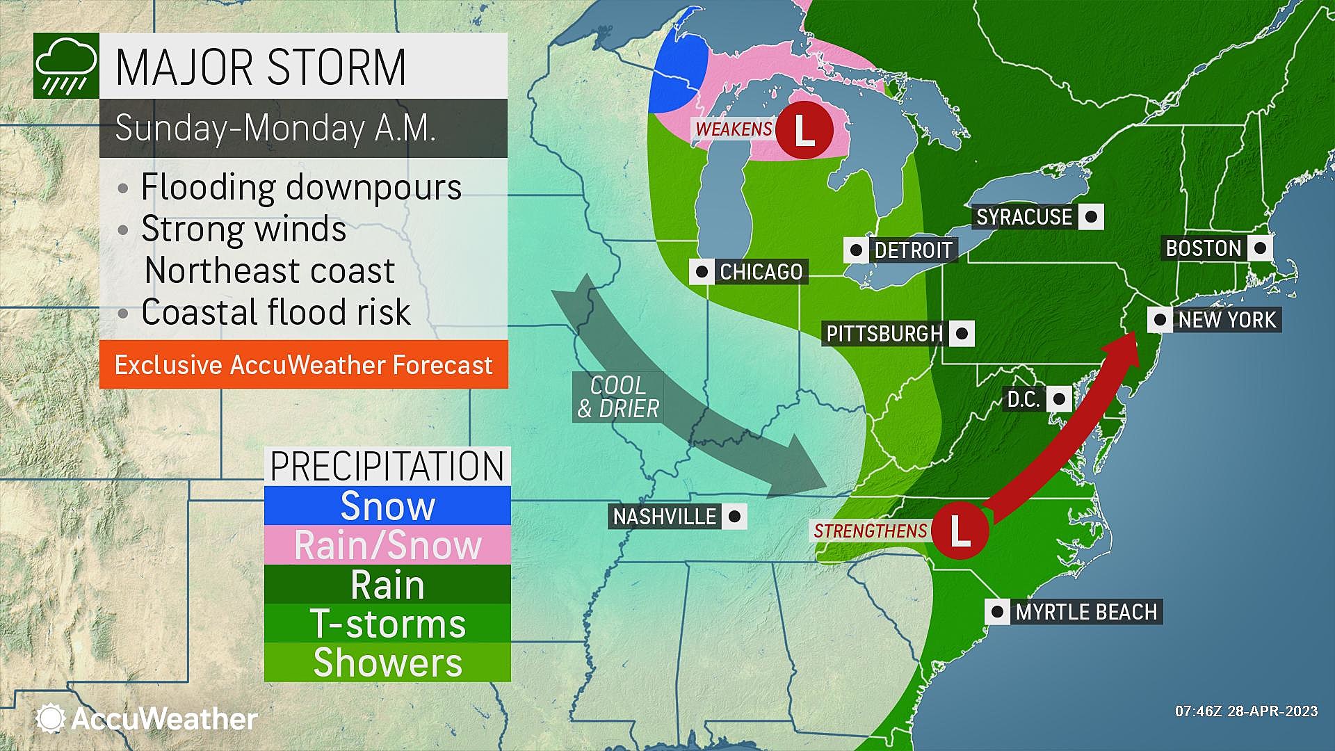
—Sunday Morning... Scattered rain returns after about 7 a.m.
—Sunday Afternoon... The brunt of the second storm (and perhaps the entire weekend), with pockets of heavy rain, rumbles of thunder, and gusty winds possible.
—Sunday Night... Rain will finally end between about 6 p.m. and Midnight Sunday.
Impacts
—Rainfall... Each storm system will soak the Garden State with a consistent 1" of rain, give or take. The Sunday storm in particular could overperform, with upwards of 2" in spots. Therefore, total rainfall will be 1 to 3 inches across New Jersey. Highest totals probably along the coast. This means New Jersey will end up with above-normal precipitation overall for April.
—Flooding... The ground should happily soak up most of the rain that falls over the next few days. However, pockets of very heavy rain could inundate storm drains and cause some ponding and flooding issues. Be extra vigilant when driving, and never attempt to cross a flooded roadway.
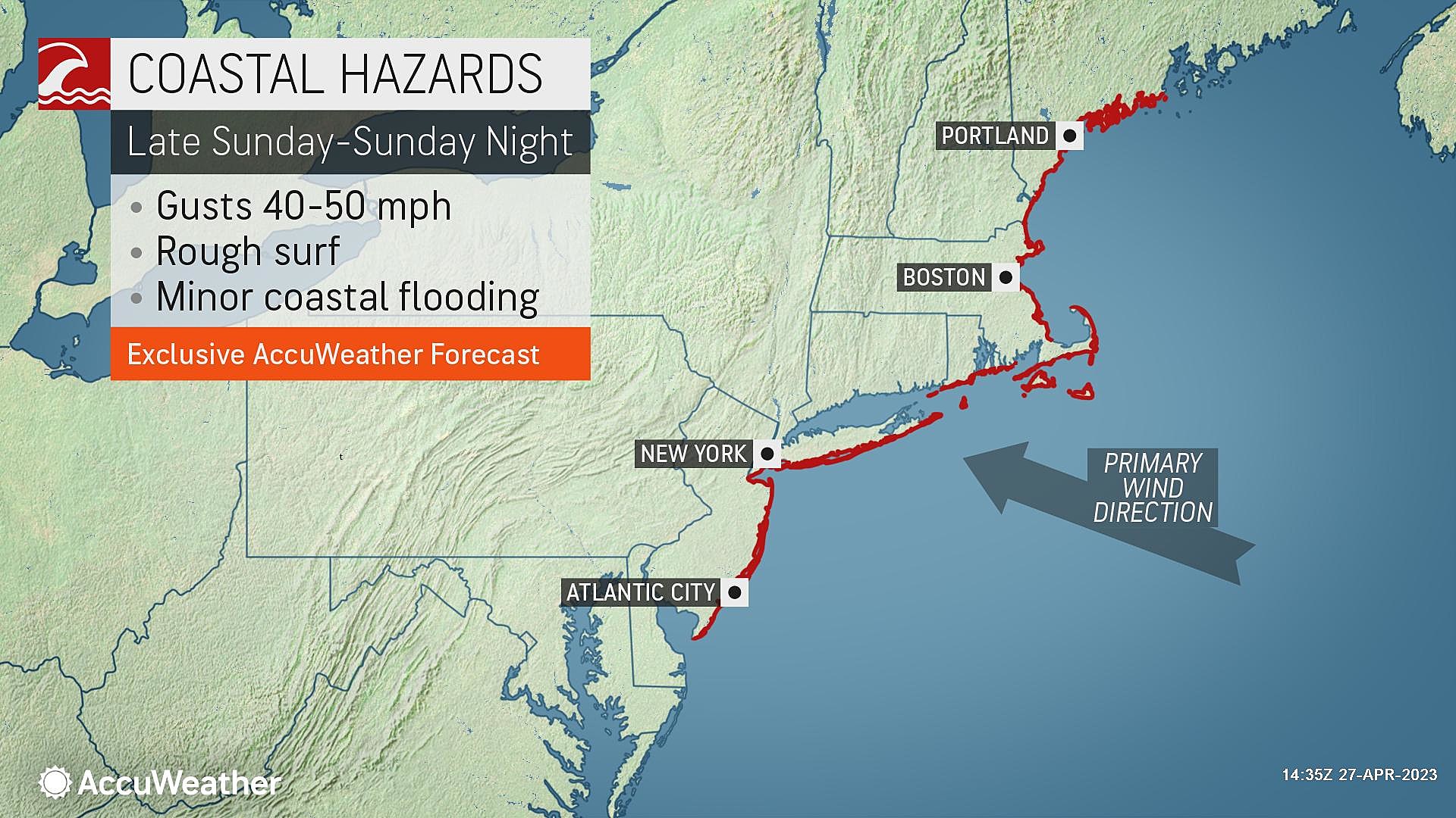
—Wind... In areas of heavy rain, wind gusts of 30-40 mph may develop. There is concern that strong winds about a mile overhead (on the order of 70-90 mph) may mix down to the surface as thunderstorms develop. Best chances for stronger winds would be Saturday morning and Sunday afternoon/evening.

—Hail/Tornado... Threat is very low.
—Coastal Flooding... Even though these are powerful storm systems, and winds will generally be easterly through the weekend, widespread tidal flooding is not anticipated. The one high tide cycle to watch will be Saturday morning's, as a foot or two of water rise could cause some localized issues.
—Temperatures... During steady rain, it is going to remain miserably cool. Expect only 40s and 50s for Friday and Friday night. Saturday's break in the rain could allow thermometers to briefly hit 60 degrees (especially to the south and west). Sunday's highs could spike into the 60s too, as the second storm system carries in warmer air. All of those numbers are below normal for late April. (Normal highs 65 to 67 right now.)
Advisories
There are no warnings, watches, or advisories posted for New Jersey at this time. If the threat for flash flooding, river flooding, coastal flooding, or strong winds increases, the appropriate advisories may be issued.
After the Storms
Quiet weather returns to start the month of May on Monday. In fact, it looks like a beautiful day, with mostly to partly sunny skies, dry weather, and high temperatures in the lower 60s. It will be quite breezy too.
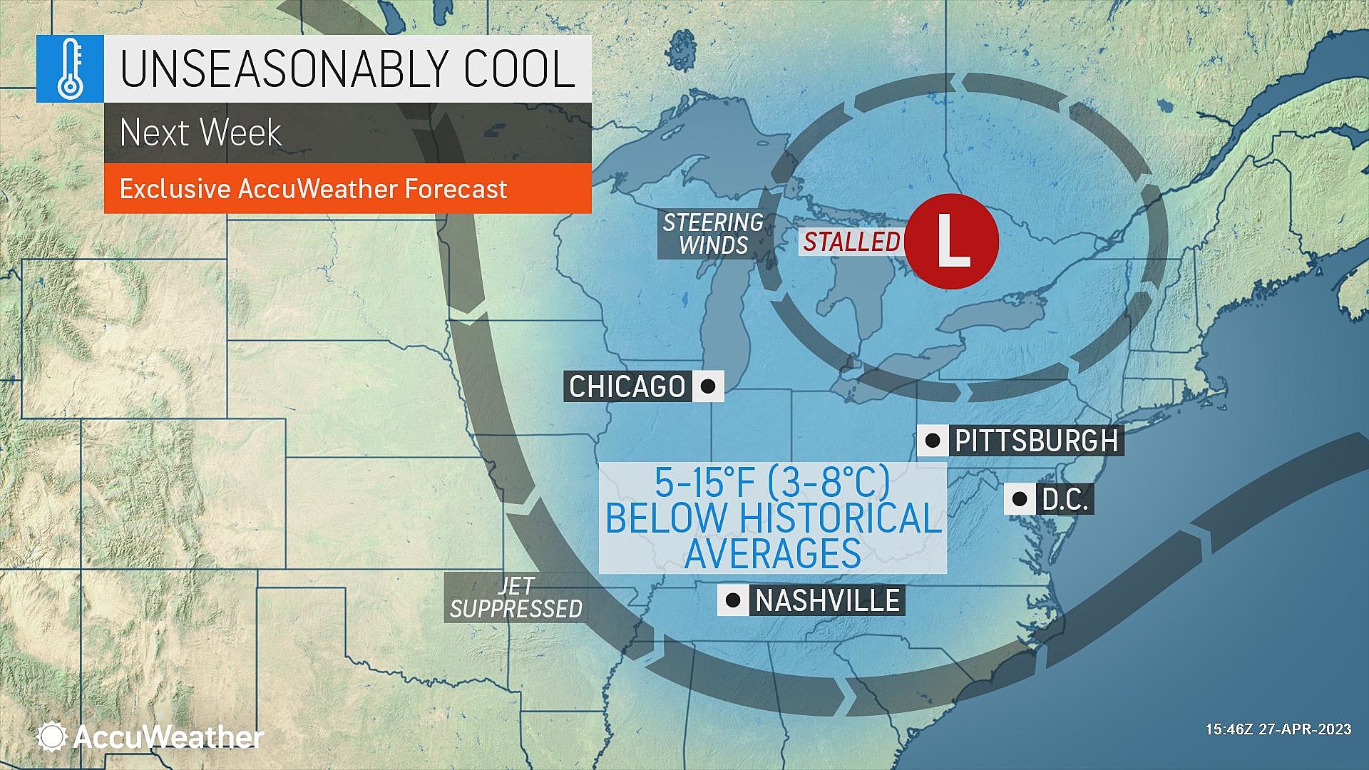
Models are showing some spotty showers around NJ on Tuesday and Wednesday of next week. As a result of raindrops and clouds, I suspect temperatures will be held below seasonal normals for most of next week too.
Dan Zarrow is Chief Meteorologist for Townsquare Media New Jersey. Follow him on Facebook or Twitter for the latest forecast and realtime weather updates.
BEEP BEEP BEEP: These are the 13 types of Wireless Emergency Alerts auto-pushed to your phone
Gallery Credit: Dan Zarrow
11 reasons why storm chasing in NJ is a very, very bad idea
Gallery Credit: Dan Zarrow
More From New Jersey 101.5 FM


