
NJ weather: Hot Friday, much cooler with rain showers Saturday
The Bottom Line
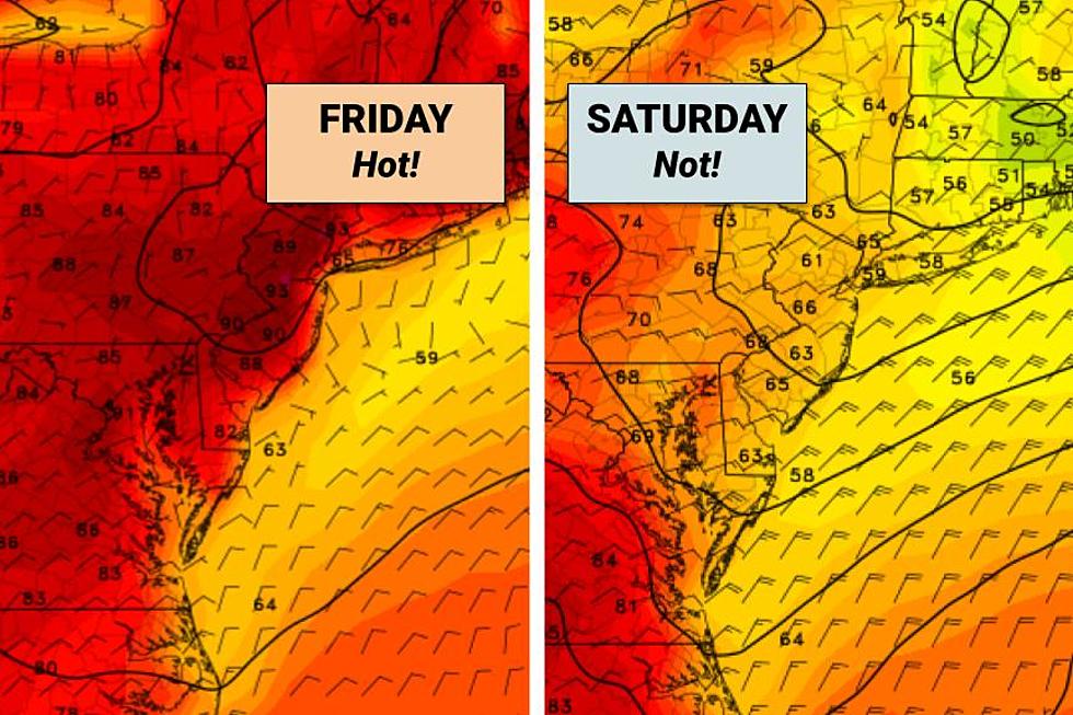
The grand finale of this week's warming trend is here. In fact, Friday will probably be the hottest day of 2023 so far for much of New Jersey. A great beach day, as inland NJ roasts in the 90s.
However, the summerlike warmth will not last into the first weekend of June. A backdoor cold front will push temperatures about 25 degrees cooler on Saturday.
There will be some rain around too. But not the kind of soaking we really need to quench drought and wildfire concerns. Of course, that also means the weekend will be far from a washout. Just unsettled and cooler.

Friday
It is important to note that this is not "dangerous heat". The morning is cool. Humidity levels are manageable. And the 90s only last one day. Make sure you dress for the weather and stay hydrated. But at least New Jersey won't feel "tropical" yet.

There is an air quality concern though, partially due to the ongoing wildfires in Nova Scotia, Canada and Burlington County, New Jersey. Friday we add ground-level ozone to the mix, due to the heat and stagnant air. An Air Quality Alert Code Orange has been issued for most of the state. That means those especially sensitive to dirty air — the very old, the very young, and those with heart and lung conditions — should limited time outdoors.
Friday's temperatures are pretty remarkable because the afternoon will be 30 to 40 degrees warmer than the morning. That extreme only happens a few times a year.
We are averaging 50s to start this Friday morning. Comfortably cool. There is a bank of stratus clouds and low-hanging fog along the coast. Hopefully that does not last long, allowing for sunshine to dominate the day.
Temps will rise rapidly by mid-morning, peaking around 90 degrees for the interior of New Jersey. The coast will be cooler, thanks to an on-shore breeze. I'm thinking we'll see 70s on barrier islands and near 80 on mainland beaches.

Speaking of the beach, I am happy to pass along that our rip current risk has dropped to Low. Ocean temperatures are still cool, around 63 to 65 degrees. Given the hot weather, it should still be a popular day at the Jersey Shore.
Humidity levels will tick up a bit Friday afternoon, as dew points surge into the 60s. Cloud cover will also start to increase through the afternoon.
And then we will have to watch the sky for a few popup showers and thunderstorms, starting around 3 or 4 o'clock. Isolated pockets of rain seem most likely across the northern third to half of the state.
We should stay on the mild side Friday night, with low temperatures dipping to around 60.
Saturday
Saturday's main weather drive is a "backdoor" cold front. So named because it pushes in from the northeast, from the ocean side. That runs opposite to our usual weather patterns which come through the "front door," rolling from west to east.
Anyway, a backdoor cold front is scheduled to arrive in New Jersey early Saturday morning. That will likely drive in a round of spotty rain showers. And it will send both temperatures and dew points tumbling a bit.

As I mentioned, we will start Saturday morning close to 60 degrees. And then highs will only reach the 60s Saturday afternoon — a far cry from Friday's 90s. It will be breezy too — easterly at 20 mph — making it "feel" even cooler.

Skies will be mostly cloudy. But rain will be limited to the first half of the day. Not everyone in New Jersey will get wet necessarily, and rainfall totals should stay below a quarter-inch. Nowhere near a washout, so there is a good chance your outdoor plans can go on as scheduled.
Sunday
The brighter, better day of the weekend. Although temperatures will still be held below normal for early June.
After a morning in the 50s, we should see pleasant lower 70s Sunday afternoon. For the first time in over a week, our predominant wind direction will turn to come from the land rather than the sea, becoming northwesterly. So even the coast is looking good.
Skies on Sunday will progress from partly sunny to mostly sunny. And I'm keeping a rain-free forecast all day.
Monday & Beyond
As usual, the medium-range forecast becomes less clear. Monday has flipped from unsettled to fine. Look for a mix of clouds and sun, with highs in the mid 70s.
We may push closer to 80 degrees on Tuesday. Then another cold front (a "regular" one this time) could introduce minimal showers and cooler air for Wednesday.
One more item we are watching: Tropical Depression 2 has formed in the Gulf of Mexico. It is drifting south toward the west coast of Cuba, and is not expected to intensify into a tropical storm.
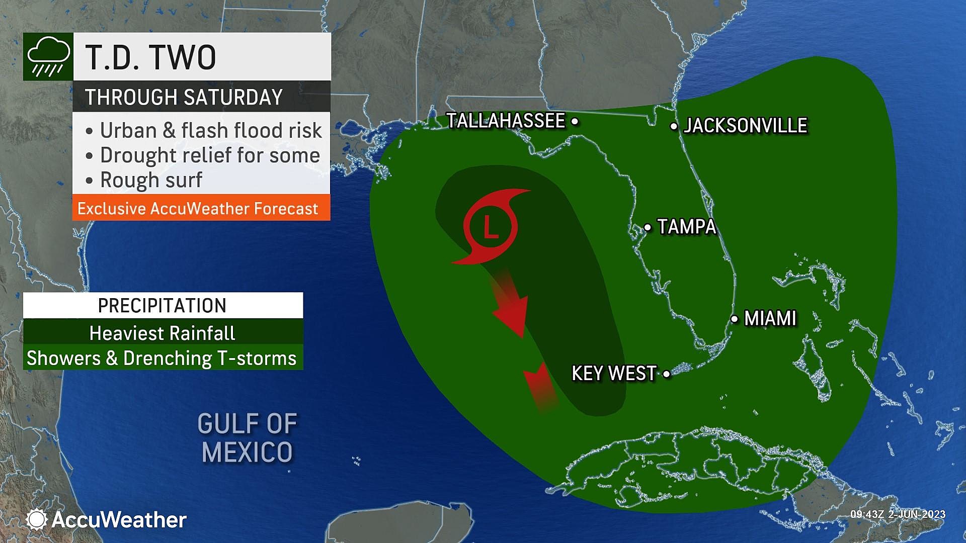
We will see where that tropical moisture travels in the atmosphere in the coming week and weeks. Atlantic hurricane season officially started June 1st.
8 Simple Boardwalk Commandments To Follow While At The Jersey Shore
Gallery Credit: Buehler
Dan Zarrow is Chief Meteorologist for Townsquare Media New Jersey. Follow him on Facebook or Twitter for the latest forecast and realtime weather updates.
7 Gorgeous New Jersey Beaches to Check Out This Summer
More From New Jersey 101.5 FM


