A foot of snow and blizzard conditions now expected across most of NJ
Good afternoon, New Jersey. We are now about 12 hours away from the first snowflakes and raindrops arriving from the storm system that literally everyone is talking about. And all signs are still pointing to a high impact winter storm with widespread heavy snow, strong winds, and prolonged travel impacts across the Northeast U.S.
To an extent, not much has changed since my last forecast post early Saturday morning. But because forecast models are still holding strong, confidence continues to grow that double-digit snowfall and blizzard conditions will verify. That is why I have decided to issue this quick afternoon update.
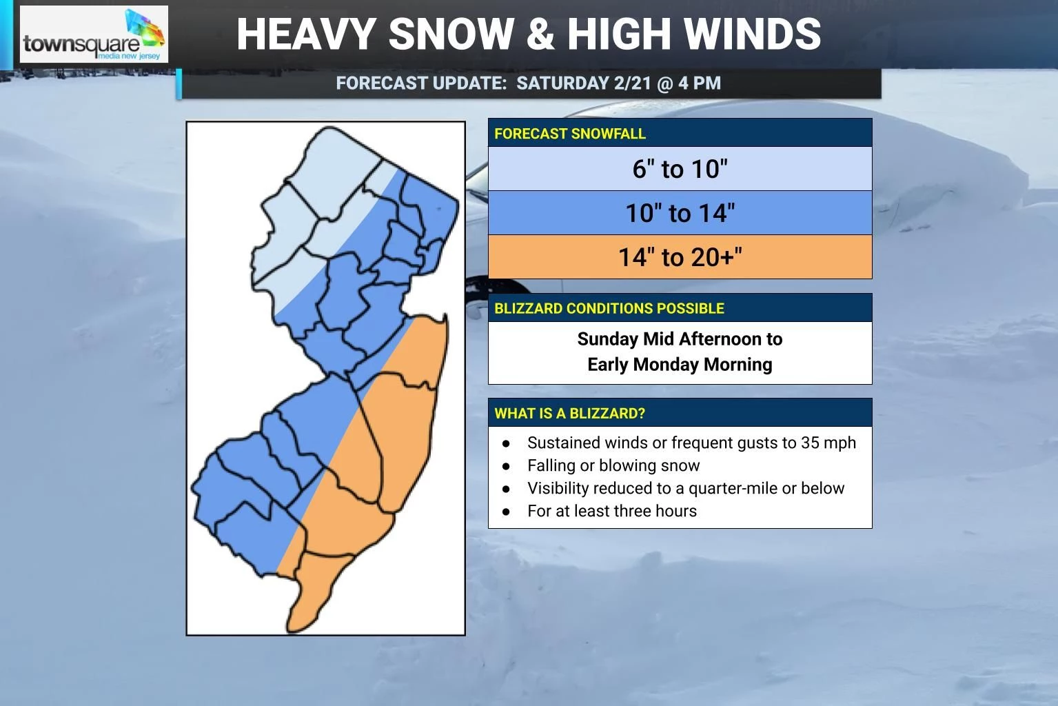
New snow map... I only tweaked my contours, decided to leave my 20+ inch coastal maximum total alone, and raised inland accumulations by about 2 inches all around. So that puts new snow totals at 6 to 10 inches for northwestern New Jersey, 10 to 14 inches on either side of the Turnpike corridor, and 14 to 20+ inches along the coast. No matter where you are, that qualifies as "major" or "heavy" snow accumulation in my book.
Model madness... The NAM mesoscale (short-range) model continues to show near-record 30+ inches of snow accumulation over New Jersey. Wow. But I still just don't fully buy it. Too many things can go wrong to "bust" such extraordinarily high totals, from rain mixing in to antecedent ground conditions being too warm to subsidence (sinking air) to dry-slotting. All other guidance has come into line with a much more reasonable consensus of just under 2 feet of snowfall along the coast. (Of course, that's still a heck of a lot of snow.)
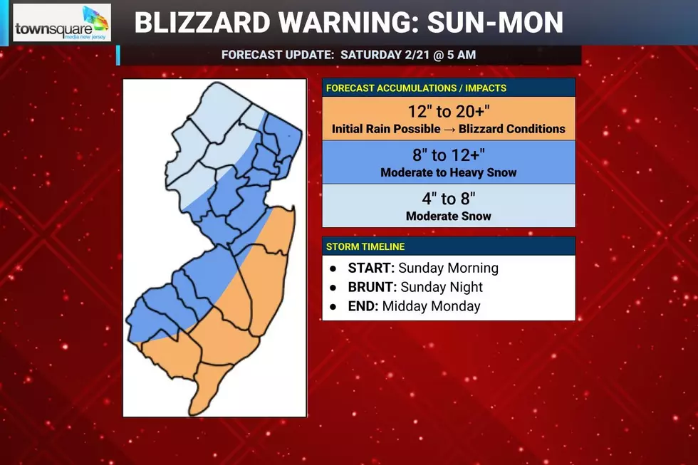
When to hunker down... Sunday morning and early afternoon will be OK, as light rain and snow spread through the state. Then conditions will start to go downhill by mid to late afternoon. The brunt of the storm, with heavy snow bands and increasing wind, will be Sunday evening and overnight. Snowfall of 1 to 2+ inches per hour will join 40 to 60 mph wind gusts to make travel conditions dangerous, if not impossible. I believe it will still be snowing heavily for most Monday morning, not tapering until about midday, give or take.
Expanded Blizzard Warning... The National Weather Service has now issued blizzard warnings for 17 of New Jersey's 21 counties, all but Sussex, Warren, Hunterdon, and Salem. They are in effect from midday Sunday through Monday evening.
Defining a blizzard... Since many New Jerseyans are confused, I want to offer the official definition of a blizzard once again. It has nothing to do with how much snow falls. It's all about wind, visibility, and dangerous travel conditions. A blizzard occurs when sustained winds or frequent gusts cause blowing or falling snow to cause visibility to drop at or below a quarter-mile for at least three hours. Such conditions are possible almost statewide Sunday night.
Upgrade to Coastal Flood Warning... Along the Jersey Shore, the previous watch has become a warning. This was expected. Tidal guidance still suggests one round of Moderate category flooding at high tide late Sunday night, followed by one round of Minor flooding midday Monday. That moderate flood crest will come perilously close to major flood stage in spots, by the way. There could be some notable water inundation issues — on top of the ongoing snow and wind concerns, of course.
The next two storms... Heh, and you thought winter was over? No way! The extended forecast has another push of light snow coming through New Jersey on Wednesday morning, with another inch of accumulation possible. And then a potentially messy storm system is plugged in for Thursday night into Friday morning. Uncertainty is high with that one — I do not want to dig too deeply into the details there until this weekend's storm passes.
Next forecast update... I am going to take one more stab at this winter storm forecast early Sunday morning before stuff really hits the fan. Just in case there are any last minute wiggles or wobbles or surprises to account for. Then our coverage will turn to "nowcasting" through the storm — at that point, we will not be talking about storm total accumulations anymore, but rather current conditions, when things will ramp up and wind down, etc.
The Blizzard of '96 Revisited: Snow totals for every NJ county
Gallery Credit: Joe Votruba
Dan Zarrow is Chief Meteorologist for Townsquare Media New Jersey. Follow him on Facebook for the latest forecast and realtime weather updates.
Remembering New Jersey's last real blizzard: January 2022
Gallery Credit: New Jersey 101.5 users
More From New Jersey 101.5 FM