

NJ gets a break from flooding and storms, still unsettled and humid
After a night of heavy rain and wicked thunderstorms for part of New Jersey, our weather will start to calm down Thursday. Having said that, it is going to be a rather unsettled weather day, with a stalled frontal boundary draped overhead. That will keep thick clouds and showers overhead throughout the day, which will also keep temperatures from climbing all that much. By Friday, we should see the return of partial sunshine and seasonable temperatures, a trend that will continue into the weekend. While each of the next three days does include the chance of an isolated shower or thunderstorm, overall I like what I see in the forecast here.
Thursday NJ weather: Blah and unsettled
Don't get me wrong here — I don't mean to imply that "blah" weather is a bad thing. This week's stormy weather has been exhausting, and I think we're all ready for a break from the onslaught of hazardous weather.
In case you missed it, South Jersey got soaked Wednesday night by up to 2 inches of rain. We just barely missed out on 3 to 4 inches of rain that fell over southeastern Pennsylvania and northern Delaware — keep in mind, you may encounter some residual flooding issues heading through the Philadelphia metro area Thursday morning.
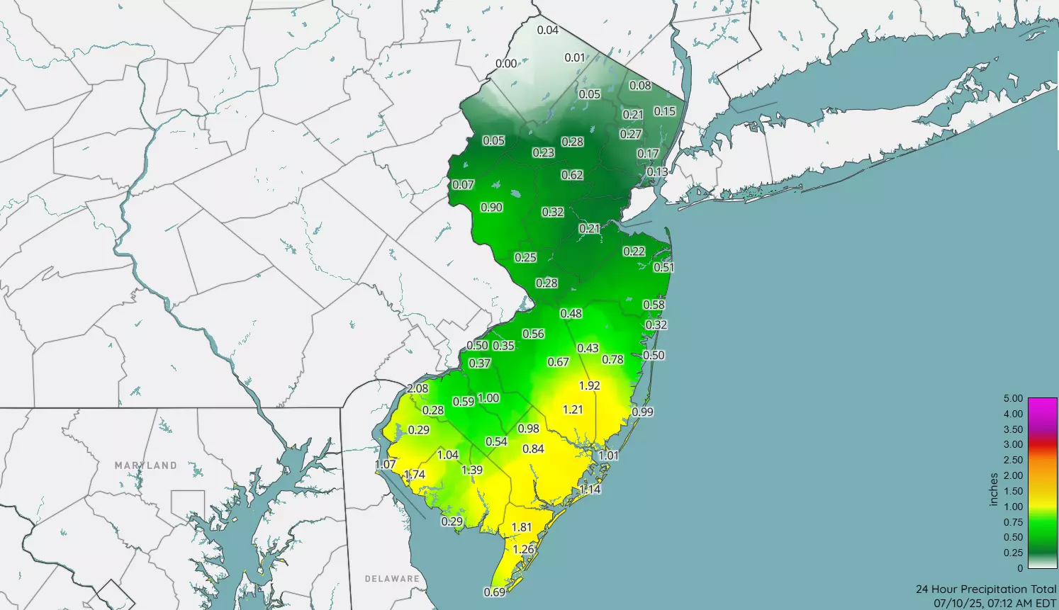
Back in Jersey, one particularly nasty storm cell scraped through Cape May, Atlantic, and southern Ocean counties with some severe wind gusts. And it even had some solid tornado rotation for a bit over Brigantine, Tuckerton, Little Egg Harbor, Holgate, and Beach Haven. (I have not seen any damage reports or confirmation of a tornado touchdown, but I will let you know.)
Looking ahead, a stalled frontal boundary will keep our weather cloudy and showery Thursday. There are no watches, warnings, or advisories in effect for New Jersey for the first time this week, I am happy to say.

According to model guidance, we will catch a relative lull in rain Thursday morning, before waves of occasional showers return through midday and the afternoon. There could be some rumbles of thunder around. The best chance for additional raindrops will drift to the south and east as the day goes on.

Because of the cloudy, damp weather, temperatures will be held at bay. We are in the upper 60s (north) to lower 70s (south) Thursday morning. Look for highs in the upper 70s (south) to lower 80s (north) Thursday afternoon. (Yes, I typed that correctly — North Jersey will likely be warmer than South Jersey, given the location of rain bands later on.)
After sunset, rain chances diminish as skies stay mostly cloudy. It will be sticky overnight, with low temperatures again around the 70-degree mark.
Friday NJ weather: Improvements
I have seen a few people complain on social media that their weather app has a rain chance in the forecast for each of the next several days. And yes, that is true. But starting Friday, and lasting through the weekend, I really think that is only an isolated shower or thunderstorm at best. In other words, raindrops are the exception here. The majority of time each day should stay dry. And the majority of the state should enjoy dry and seasonably warm weather for the duration.

Friday will feature partial sunshine and near-normal high temperatures in the mid 80s. You really can't complain about that here in mid-July. Yes, it will still be humid. And yes, there could be a few stray showers or thunderstorms around, especially early and late in the day.
Saturday NJ weather: Typical summer weather
Just like Friday, this weekend's weather will not be perfect. But I think it will be bright enough, dry enough, and warm enough to catch plenty of beach and pool time. There are no organized or widespread weather systems to worry about.
Under a mix of sun and clouds, Saturday's high temperatures will reach the mid to upper 80s. Again, totally typical for this time of year. The Jersey Shore will benefit from a sea breeze, likely keeping air temps in the 70s.
Dew points will still be in the 70s, so the heat index (the "feels like" or "apparent" temperature) will reach the 90s. Sweaty, but not inherently dangerous.
A few popup thunderstorms are possible, which could produce some locally heavy rain and/or dangerous cloud-to-ground lightning. But again, they will be isolated. And hopefully brief.
Sunday NJ weather: More of the same
Sunday reads very similar to Saturday. Maybe slightly sunnier. And a degree or two warmer.
Let's call it partly to mostly sunny, with highs 85 to 90 degrees. Smells like summertime in Jersey.
Monday NJ weather: Spotty thunderstorms possible
New Jersey's weather machine cranks into a higher gear again next week, as things potentially turn hotter and stormier again.
I think we will see a return of 90s, if not by Monday then by Tuesday and Wednesday. It will still be humid, of course. And along with heat and humid will come a chance of spot thunderstorms. Right now the best chance of storms looks to be Monday afternoon, although it is not necessarily an "everywhere gets wet" kind of situation".
When could we get some relief from the soupy air? We need a strong cold front, and I don't see that coming along until late next week at the earliest. So keep on sweatin' and keep your air conditioner happy. We still have a lot of summer left ahead of us, New Jersey.
Great Places In New Jersey For A Sunrise Or Sunset Picture
Dan Zarrow is Chief Meteorologist for Townsquare Media New Jersey. Follow him on Facebook for the latest forecast and realtime weather updates.
Some Of New Jersey's Best Candy Shops
Gallery Credit: Lou Russo
More From New Jersey 101.5 FM


