
Cool Jersey: Temps almost 20 degrees below normal Tuesday
What a nice January day across the Garden State! Too bad it's April. And a trend of unseasonably cool weather is expected to continue for a while.
Here are your weather headlines for Tuesday, April 5, 2016...
There's a Chill in the Air
Brrr! Thanks to a chilly air mass that has settled over New Jersey, temperatures will remain well below normal for the next 48+ hours. With weather more reminiscent of mid-winter than early spring, be prepared to do some significant "bundling up" throughout this first full week of April.
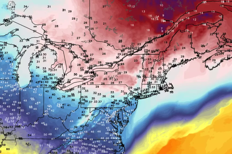
Tuesday morning lows were below freezing for most of the Garden State. Afternoon highs will end up close to 40 degrees. That's about 15 degrees below normal for this date. In addition, a brisk northerly wind may gust to 35 mph on Tuesday. That means the biting wind chill will be back, keeping "feels like" temperatures in the 30s at best, all day long. At least our weather will be sunny and dry, amidst the cold.
Thermometers dip even further into the blue Tuesday night. Overnight low temperatures are forecast to end up between 19 and 27 degrees. Record low temperatures may be in jeopardy on Wednesday morning.
Temporary Warmup
Warming temperatures will kick-in Wednesday, as highs climb to around the 50-degree mark. That's still below normal for early April, but at least it's something. Look for partly sunny skies and a continuing brisk 15 to 25 mph wind.
Thursday's temperature forecast looks good! We should end up around 60 degrees, with a nice southerly breeze. Unfortunately, the warmth comes at a cost - we are expecting scattered showers and thunderstorms on Thursday too. Severe indices suggest that some of those storms could be on the strong side, so this will be a day to watch as the week presses on.
Looking Ahead...
Don't get used to Thursday's mild temperatures, as another intrusion of cold air will attack New Jersey by the weekend. Friday's high temperatures will fall to the lower 50s as cooler air leaks in from the northwest.
You will really feel the cooler air on Saturday, as high temperatures will be once again limited to the upper 30s to lower 40s. A slow warmup with quiet weather is expected for New Jersey through early next week.
More From New Jersey 101.5 FM


