

Thursday NJ weather: Near-record warmth, then rain, then tumbling temps
The Bottom Line
New Jersey's next big weather transition is just around the corner. While high temperatures will flirt with 70 degrees Thursday afternoon, a strong cold front will drive in active weather Thursday night. First, a period of steady to heavy rain will sweep across the entire state. And then, temperatures crash.
Friday's highs will be almost 25 degrees colder than Thursday's. Ouch!
Temperatures will moderate a bit this weekend. And there's a lot of hype floating out there about a storm system next week — but I remain unimpressed and unconvinced it's going to be a big deal for the Garden State.
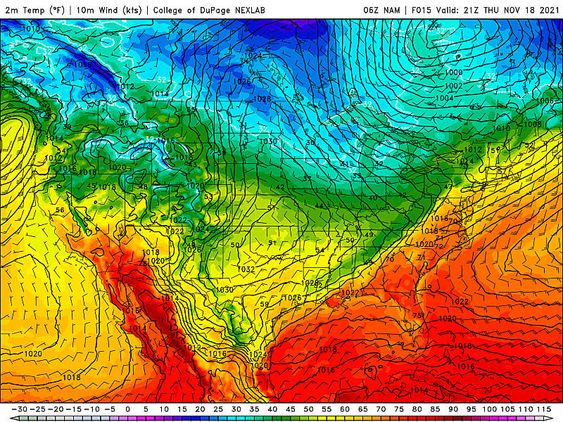
Thursday Part 1: Near-Record Warmth
The warm spot in New Jersey on Wednesday afternoon was West Deptford, Gloucester County where the thermometer hit 67 degrees. Of course, Wednesday morning's low temperature there was a frigid 27 degrees. A 40-degree diurnal range for the day — that's impressive!
Thanks to a warmer start, continued warm air advection, and pre-frontal compression, I have no doubt that Thursday will be even warmer.
We're starting the day with temperatures generally near 50 degrees. (It is notably cooler northwest of the Fall Line.) Patchy dense fog has formed in the northern half of the state, with visibility as low as a quarter-mile in spots.
Thursday's high temperatures should reach into the upper 60s to lower 70s. That is about 15 degrees above normal for mid-November, and very close to the historical record highs for the 17th of November. (Records: 73 at Newark, 76 at Trenton, 73 at Atlantic City.)
Morning sun will eventually be overtaken by clouds. It may become breezy during the afternoon. We will stay dry during the daytime hours.
Overall, a really nice, mild November day. (Unless you are suffering from allergies, that is.)
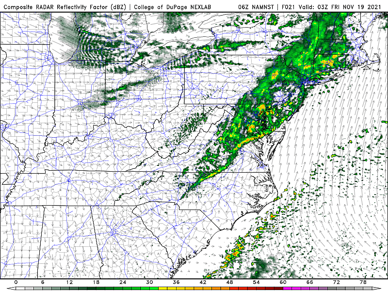
Thursday Part 2: Rain
Our next storm system is a cold front, set to arrive Thursday night. It will drive in wet weather, and then put an end to our brief warm streak.
Rain will creep into western New Jersey between about 6 p.m. and 9 p.m. The band of rain should progress to the coast by about 8 p.m. to 11 p.m. Following a few hours of raindrops, we'll dry out early Friday morning, between about 2 a.m. and 5 a.m.
As I have mentioned previously, I am not at all concerned about winter weather, severe weather, or even thunder and lightning. There could be some pockets of moderate to heavy stuff, making roads slick and overnight travel tricky. But it's just rain.
Thursday/Friday Part 3: Tumbling Temps
I think the biggest question mark of this big transition is how quickly temperatures will tank as our new, colder air mass arrives Thursday night.
By the time you wake up Friday morning, the wintry chill will be back. Temperatures will be in the upper 30s to lower 40s — maybe cold enough for some frost. And it will be breezy and blustery too, with northwesterly wind gusts over 20 mph.
Highs on Friday will be limited to the mid to upper 40s. So we're right back to the December-ish weather of early this week. At least the wind will die down and skies will become mostly sunny.
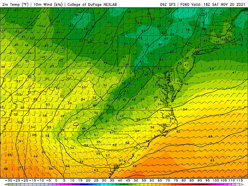
The Weekend: Cool & Quiet
Saturday morning will be quite cold and quite frosty, with low temperatures near the freezing mark in the lower 30s. Saturday afternoon will be partly sunny, with temps similar to Friday, in the 40s.
A southerly wind and rising humidity will push temperatures a bit higher on Sunday, into the 50s. It will be the cloudier day of the weekend, but I'm keeping a dry forecast during the day.
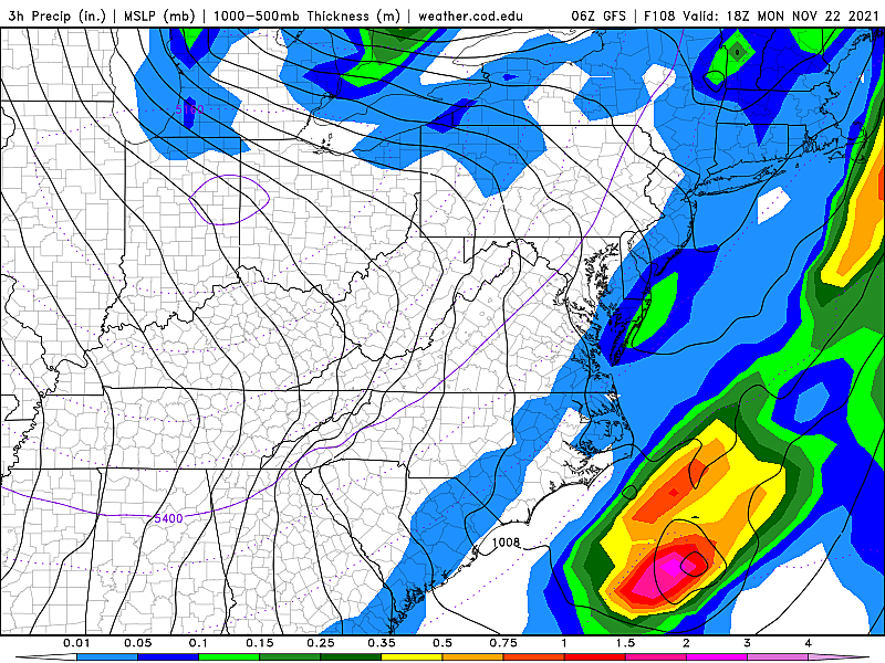
Next Week: Potential Storm?
Even though models have drifted far from a worst-case snow/heavy rain solution, some of my meteorological colleagues are still hyping up next week's storm. Granted, it is an increasingly busy travel period, as the Thanksgiving holiday approaches. But I remain unimpressed, as the complex will not phase into a highly impactful nor'easter.
We will get wet. The bulk of the precipitation looks to fall as rain on Monday morning. Potentially "yucky". Maybe "nasty," if the wind kicks up. And wet conditions could affect inbound and outbound flights.
As the storm system departs Tuesday into Wednesday, things could admittedly get a bit more interesting.
Another burst of cold air will keep high temperatures to about 40 degrees — akin to the dead-of-winter. And enough of our atmosphere will be freezing such that any wraparound or lake-effect showers will fall as snow.
In fact, some forecast models do show upwards of an inch of snow falling in North Jersey over the course of next week. But again, I am not overly concerned about travel conditions at this time. But these types of systems are highly track and temperature sensitive, so it's still worth watching for sure.
Dan Zarrow is Chief Meteorologist for Townsquare Media New Jersey. Follow him on Facebook or Twitter for the latest forecast and realtime weather updates.
Things to do in Salem County, NJ
Gallery Credit: Dino Flammia
25 True Crime Locations: What Do They Look Like Today?
More From New Jersey 101.5 FM


