Thursday NJ weather: From wet to dry, clouds to sun, humid to not
The Bottom Line
Thursday is still a day of transitioning, improving weather. We start with rain and thunderstorms, but will end drier. We start with mostly cloudy skies, but gradually clearing will take over by late afternoon. And we still have some sticky humidity in the air, which will slowly dial back.
One more weak cold front Thursday night will zap the humidity from the air, making things much more comfortable. Refreshing.
You will find a September-ish feel in the air as we start this mid-August weekend. A rain chance creeps into the forecast at the end of the weekend into early next week. Fingers crossed for a good soaking — remember, part of NJ is running a 6+ inch rainfall deficit this summer.

Thursday
It's raining, it's pouring. We start Thursday morning with a pocket of heavy rain and thunderstorms driving west-to-east across central and southern New Jersey. Radar estimates suggest Gloucester and Camden counties picked up over two inches of rainfall.
The rain is only a morning thing. The biggest cluster of heaviest rain will push off the coast by 7 or 8 a.m. And then lingering showers will exit by 10 or 11 a.m.
For the rest of the day, we'll see mostly cloudy skies with gradual clearing. Hardly any breeze, and zero rain chance in the afternoon. High temperatures should end up in the seasonable mid 80s. There's a good chance (although not a guarantee) that we miss the 90-degree mark statewide for the first time since August 1st.
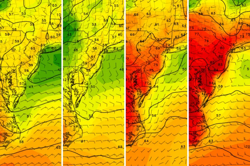
Meanwhile, it's still a little sticky. We often refer to the dew point as our measure of moisture in the air — it is our summertime "muggy meter". Dew points will slowly descend from the steamy 70s into the sticky 60s as Thursday presses on. They will jump downward one more time Thursday night, into the 50s.
One more weak cold front Thursday evening will bring us that final shot of dry, comfortable air. That front could spark a brief rain shower at some point Thursday night too.
With a few clouds overhead, temperatures should bottom out in the upper 60s by Friday morning.
There is one more item worth noting. A Coastal Flood Advisory has been issued for Thursday evening. Not for the Jersey Shore, but rather for the Hudson River basin of northeastern New Jersey. One to two feet of extra water rise is possible, amounting to minor category flooding. There are some very vulnerable spots around Hudson, Essex, and Union counties. So it is worthwhile to be aware and vigilant, especially between about 7 p.m. and Midnight Thursday.
Friday
Ahhh, we catch a breath of refreshing, non-humid air. High temperatures will also end up a shade below normal for the middle of August, reaching the lower 80s.
I've been fighting with myself about whether sun or clouds will "win" the sky on Friday. I have settled on a mix of both. It should be pleasant. And dry.
Saturday
Saturday is going to bring a taste of September-ish weather to New Jersey.
There could be some cool 50s on the temperature map Saturday morning. And highs are forecast to end up right around the 80-degree mark. Again, below normal for this time of year. (Although not by too much.)
An area of low pressure is expected to be just off-shore on Saturday. But I'm hedging that it will be far away enough to not pose a problem in terms of sky cover or precipitation.
Sunny, dry, and pleasant. And again, you will love the low humidity.
Sunday
Sunday gets a bit trickier, as our next storm system approaches from the west.
Some models have crept in showers as soon as Sunday morning. I favor a much later solution, with raindrops holding off until Sunday late afternoon or evening (at the earliest).
Regardless, clouds will increase on Sunday. Humidity will bump up slightly — but not high enough to pose a problem. And it will also be the warmer day of the weekend, with highs between about 80 and 85 degrees for most of the state.
The Extended Forecast
Monday could be pretty wet. And given our spiraling drought concerns, that would be a very good thing.
Both the GFS and the Euro models show pockets of rain dampening New Jersey throughout the daytime hours on Monday. But the consensus of "how heavy" and "how much" and "who gets soaked the most" is still weak or non-existent. That's not surprising for a 96+ hour forecast, of course.
Bottom line: I would expect a damp and dreary day Monday. That will keep temperatures even cooler, likely in the 70s.
Leftover showers and clouds are possible on Tuesday, but we should get some sun eventually. Wednesday looks mostly sunny and comfortable. High temperatures 80 or better both days.
There are no hints of extreme heat at all in the next seven to ten days, at least. And a disorganized tropical wave way out in the Atlantic still has a long way to go before threatening the U.S. East Coast.
Dan Zarrow is Chief Meteorologist for Townsquare Media New Jersey. Follow him on Facebook or Twitter for the latest forecast and realtime weather updates.
RANKED: Here are the most popular national parks
Did you know the camp from Friday the 13th, Part 1 is in NJ, and you can now tour it?
More From New Jersey 101.5 FM


