

Winter is back, NJ: Temps tumble Thursday, two snow chances this weekend
UPDATE... This article is outdated...
For the latest winter storm forecast information, please refer to my newest weather blog post.
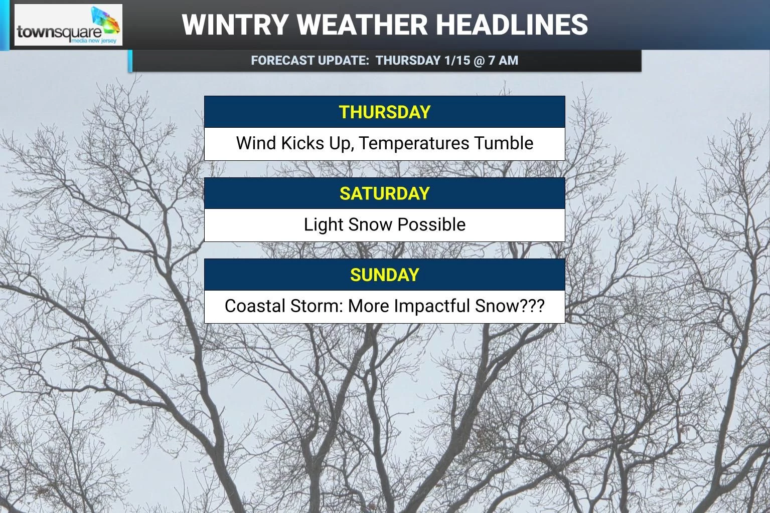
Thursday is a cold front day, as arctic air returns to New Jersey. And it's going to be here for a while this time around — this is turning into quite a wintry forecast. There are some spotty rain showers pushing through New Jersey early Thursday morning, mixing with snowflakes to the far north. There is a small concern that as temperatures drop later on, any wet surfaces could ice over, leading to slippery spots — a "flash freeze" situation. A brisk westerly wind is picking up, carrying in colder air and causing temperatures to tumble. Thermometers will drop from the 40s in the morning to about 30 degrees by late afternoon and then to around 20 degrees overnight. The wind chill will easily dip into the teens. Friday stays blustery. And then we have a pair of snow chances to watch closely over the weekend.

Thursday NJ weather: Turning windy and cold
This will be a big transition day, as we welcome winter back to New Jersey. (Whether that is a "fond" welcome is a matter of opinion, of course.)
Thursday is starting somewhat damp around New Jersey, as spotty sprinkles and showers have been pushing through the early morning hours. Very light stuff, and almost exclusively liquid with temperatures in the 40s. Only Sussex County has seen some conversational, non-sticking snowflakes.
As of this writing (7 a.m.), the wind is just starting to kick up along the western edge of the state, as our new arctic air mass arrives. Top wind gusts today will be just over 30 mph, blowing out of the west.
Partial sunshine will emerge by late morning. But temperatures will drop from the 40s in the morning to around 30 degrees by late afternoon. (A far cry from Wednesday, when thermometers were as warm as 62 degrees in South Jersey!)
So you will need the heavy winter coat later on Thursday, as wind chills ("feels like" temperatures) likely dip into the teens by sunset.
And it will only get colder Thursday night. Overnight lows will bottom out around 20 degrees. Wind chills will be closer to 10. It will be clear, dry, and breezy.
Friday NJ weather: Sunny but blustery
Friday will stay blustery, although not quite as windy as Thursday — my forecast puts top gusts around 20 mph. It will be mostly sunny and dry.
High temperatures will only reach about 30 to 35 degrees. That is a full 10 degrees below normal for mid-January, which is the coldest time of the year here in the Garden State. Wind chills will do no better than the 20s all day.
Saturday NJ weather: Temporary warmup
On Saturday, a subtle wind shift will allow slightly warmer air to come in. So it will be a slightly less frigid and more comfortable day. We'll see about 30 degrees in the morning and then lower to mid 40s in the afternoon.
Skies will be mostly cloudy though. And forecast models are now showing a weak impulse riding through New Jersey's atmosphere Saturday morning. I'm thinking this will be enough for some light conversational snow to fall around the state, with up to a dusting or coating on the ground. But I believe accumulation will be difficult here due to the dry air, the warm ground, and the limited time window it will be snowing.
(Notably, the European model forecast does show a later, colder, snowier solution for Saturday, on the order of an inch or two of total snowfall. It is currently an outlier among all guidance, so I have chosen to set it aside. But if other models start to trend colder, I might have to think about whether a bump upward in potential totals is warranted.)
Sunday NJ weather: Watching a coastal storm
Sunday is looking even more interesting, as a coastal storm slides by the Jersey Shore. This is not necessarily a surprise — in previous forecasts, it was far enough away that we just did not have to talk about it as a credible snow threat for New Jersey.
Well, now it is.
To start, Sunday will turn cloudy and colder again, with high temperatures similar to Friday — only around the freezing mark, in the lower 30s. Since we will be on the cold side of this storm, anything that falls from the sky would be all snow.
The sticky wicket in this forecast is the storm track. I can see basically two scenarios ultimately playing out for Sunday:
1.) A glancing blow. The northwestern edge of the storm system's precipitation just barely "kisses" the New Jersey coast, providing a brief period of light snow late Sunday afternoon. Accumulations would be light and brief, on the order of an inch or two at the most for coastal counties only.
2.) Westward track. This would be more impactful for all of New Jersey, as a dry, fluffy moderate-intensity snow falls for several hours from Sunday midday through early evening. In a perfect situation, I could see accumulations in this scenario potentially exceeding 6 inches for "the sweet spot" of the state.
The difference between these two solutions is only about 30 to 60 miles, by the way. Hardly anything in the grand scheme of Earth's atmosphere.
While some of my meteorological colleagues are already leaning hard toward one solution or the other, I remain unconvinced and uncertain. I want to see more data, more model guidance, and more information before I start putting out definitive forecast information. If there is a snow map to draw, I would probably look to do that Friday morning at the earliest.
Monday NJ weather: Cold week
The extended forecast for next week trends quite cold. Highs will only be in the 30s again on Monday. Skies will be bright and sunny.
And then another blast of arctic air pushes thermometers even lower on Tuesday. Morning lows in the single digits. Afternoon highs in the 20s. It seems like we get exactly one of these extreme cold snaps every year. I guess it's our time.
The next opportunity for significant snow would not come along until late next week into next weekend, at the earliest. (Next week's air mass is going to be too cold and too dry.)
Let it snow: 12 things to know about winter forecasting in NJ
Gallery Credit: Dan Zarrow
Dan Zarrow is Chief Meteorologist for Townsquare Media New Jersey. Follow him on Facebook for the latest forecast and realtime weather updates.
Glossary of NJ winter weather words and phrases
Gallery Credit: Dan Zarrow
More From New Jersey 101.5 FM


