

Cold air really stings, weekend coastal storm not a ‘snow bomb’ for NJ
UPDATE... This article is outdated...
For the latest winter storm forecast information, please refer to my newest weather blog post.
There are still two big stories in New Jersey's weather world: Cold and snow. Believe it or not, the frigid air is set to intensify slightly over the next three days, as thermometers struggle to make it past 20 degrees during the day. Thursday will be bright and sunny, with highs only around 20 degrees and a wind chill stuck at 10 degrees. Lows Thursday will be close to 0, with a wind chill near -10. Definitely in "dangerous cold" territory yet again. Quiet, frigid weather continues through Friday and most of Saturday. And then a powerful coastal storm is expected to just barely "kiss" the New Jersey coast with snow this weekend, specifically Saturday night into Sunday. Accumulations will be light, and likely limited to coastal counties only. Wind and tidal flooding impacts may turn out to be the more concerning aspects of this storm.

The deep freeze continues
I am not sure what I can say about the cold that hasn't been said already. Other than the unfortunate news that a reinforcing shot of cold air arrives soon. That means it's only going to get colder around here, before we finally get some relief next week.
Thursday will be bright and sunny, but high temperatures will only reach about 20 degrees. The wind chill will climb no higher than about 10. Some flurries or a quick snow shower are possible, especially around North Jersey in the late afternoon hours.
Thursday night, temperatures will dive into the single digits across most of the state. That means the coldest corners of the state will likely sink below zero. The wind chill will almost certainly end up well below zero, around -5 to -10. That is dangerous cold, as frostbite and hypothermia become real concerns if you do not take care of yourself.
Friday's high temperatures will only reach the upper teens. It could be the coldest day of the week overall.
Saturday's highs are forecast to be around 20 degrees, with increasing clouds.
Coastal storm track to barely 'kiss' Jersey Shore
All week, we have been keeping a watchful eye on our next weathermaker, a coastal storm setup for the weekend. While the storm track is still uncertain and subject to change, it is becoming clear that this is not setting up to be a "big storm" for New Jersey. In fact, the majority of model guidance has leaned hard in the other direction, shifting the storm out to sea as the storm passes New Jersey's latitude.
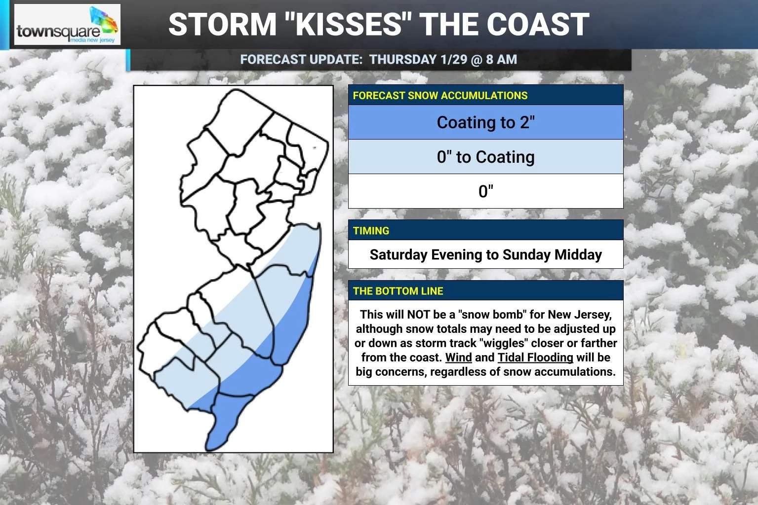
However, I think it would be foolish to downplay this storm too much and call it a complete miss at this time. As my first call snow forecast map indicates, I think there is a reasonable chance that light accumulating snow develops from late Saturday into Sunday along the southern and eastern edges of the state. As it stands, I do not expect statewide snowfall. And only minor travel impacts would occur with 2-inch snowfall.
But here's the thing: The storm is still almost 72 hours away. And so the track is still very much subject to change and "wiggle" some more, either closer to or farther away from the Jersey coast. As it does, this forecast may also need to be adjusted. I could see snow totals possibly doubling along the coast, going as high as 4" if the storm track drifts closer. Or going as low as zero statewide, if this thing clearly swings safely out to sea.
Because of that uncertainty, I may be a little early in putting out an initial snow map. But I felt the need to get ahead of some of the hype. This really is not turning into the impressive storm that it could have been. You may have read it being called a bomb cyclone, nasty nor'easter, or massive blizzard? Well, not for New Jersey. It's just a glancing blow.
In addition to minor snow accumulations, let's not ignore two other storm impacts. First is wind. Gusts to 40 mph will be possible from the storm, further reducing visibility due to blowing snow, exacerbating the cold air, and possibly sparking some power outages.
The other big concern is tidal flooding, especially with a Full Moon coming up on Sunday. As the storm's core low pressure deepens and rapidly intensifies over the ocean, it will throw lots of ocean water toward the New Jersey coast. Early estimates show about 2 to 3 feet of storm surge for 2 or 3 high tide cycles, starting early Sunday morning. I think that will put flood levels in the "moderate" category, which is pretty serious. We will have a better sense of that magnitude in the next day, so stay tuned.
How to Be Safe on the Ice - Easy to Follow Guide for Ice Thickness Safety in Winter
Gallery Credit: JD Knight
Dan Zarrow is Chief Meteorologist for Townsquare Media New Jersey. Follow him on Facebook for the latest forecast and realtime weather updates.
LOOK: The most extreme temperatures in the history of every state
Gallery Credit: Anuradha Varanasi
More From New Jersey 101.5 FM


