8 things to know about NJ’s weekend coastal storm
The Bottom Line
What a week of weather, huh? From as warm as 88 degrees on Sunday to as cold as 25 degrees Friday morning — our first real frost/freeze of the season. And now we look ahead to a potent, multi-impact coastal storm aiming for New Jersey over the Columbus Day Weekend.
Friday and Saturday's weather will be fine. Sunday and Monday will turn wet and windy, no matter where in the state you are. Coastal flooding is potentially the biggest concern of all.
There are still some lingering questions in the forecast here, especially with regard to storm track and timing. But with first raindrops less than 48 hours away, it is time to put more definitive details and numbers on the forecast. And it is time to start preparations — if any — for a period of nasty weather and high water. Our first big storm here in New Jersey in quite some time.

Before the Storm: Friday and Saturday
Friday morning is quite chilly. The northwest corner of the state has dipped into the 20s and 30s. Most of New Jersey is waking up to 40s. And the coast, insulated by the warmer ocean and bay water, is seeing air temperatures in the 50s.
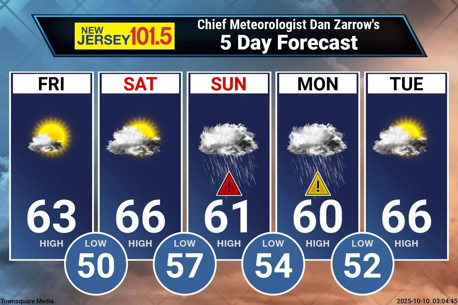
Early sunshine will give way to gently increasing clouds through Friday afternoon. It will be dry and calm and cool. Highs will reach the lower 60s, similar to Thursday. Overall, not a bad October day.
Friday night will be partly cloudy and quiet. It will not be as cold as the previous night. Lows will dip to around the 50-degree mark.
Saturday will become mostly cloudy to overcast. It will become increasingly breezy throughout the day and evening too. Highs will push into the mid 60s. It will be the only decent day of the weekend.
The only potential wrinkle Saturday will be a spot shower or sprinkle chance that may develop over New Jersey, ahead of our impending storm system. Very much hit or miss type stuff — light and brief.
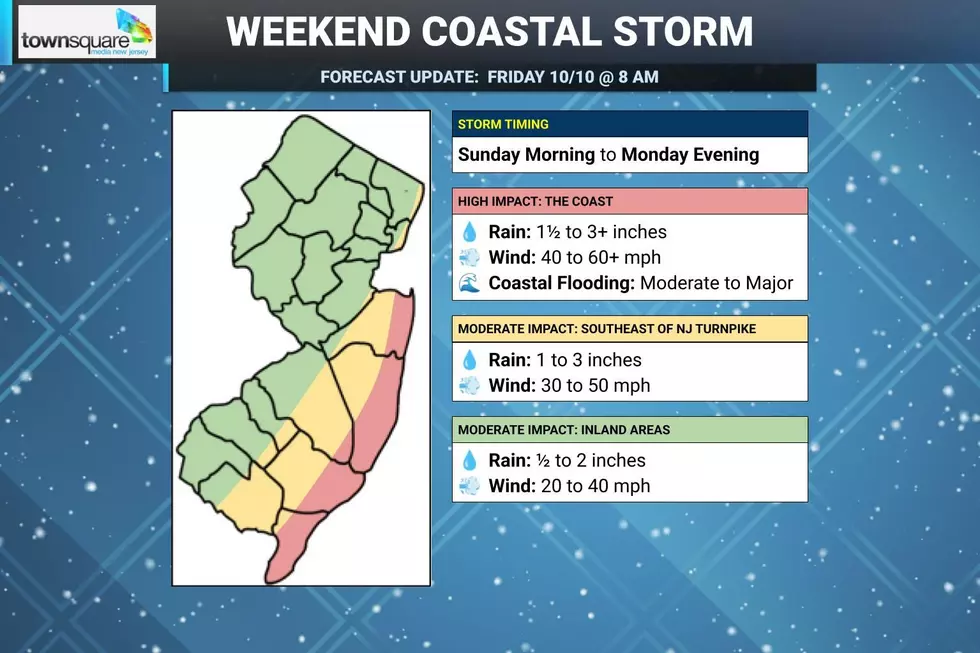
Storm Timing
Again, a stray shower is possible at any time Saturday. But the big push of rain will hold off until late Saturday evening, at the earliest.
Most likely, the coastal storm's main band of steady rain will envelop New Jersey early Sunday morning. Heavy rain will kick in through the afternoon and evening hours. As the center of low pressure approaches New Jersey at that time, wind speeds will also increase. So I think it's fair to say "late Sunday" will most likely be the "brunt" of the storm — the time of the most serious impacts.
Rain would become more scattered and broken apart (although still potentially heavy at times) on Monday, before eventually tapering off Monday night. Wind speeds would gradually decrease on Monday too, although probably still in the breezy category at least (stronger at the coast) throughout the day.
Having said all that, there is at least one forecast model — the European — that keeps the center of low pressure further out to sea Sunday, and then slams it back west on Monday. That would lead to a drier Sunday and wetter Monday, completely reversing this timeline.
Temperatures for the duration of the storm — both highs and lows — will hold pretty close to 60 degrees.
Rain
Again, rain is not the most serious impact here. Especially since 80 percent of New Jersey is now classified as Abnormally Dry and 10 percent — a swath of North Jersey — is now back in "Severe Drought" status. We really need rain, and this will be a good soaking. We just have to be vigilant for localized ponding and flooding issues.
I think 1 to 3 inches is a good statewide estimate of total rainfall from Sunday to Monday. Could final totals underperform a bit in NW NJ, far away from the core of the storm? Sure. Could totals ultimately overperform along the coast, where rain will be heavier and hold on longer? Sure.
Wind
It is definitely going to be windy, especially along and east of the Garden State Parkway corridor. A High Wind Watch has been issued for 6 a.m. Sunday to 6 a.m. Monday for coastal counties. As long as the forecast does not shift dramatically, that will convert to a warning before the storm arrives.
Near the coast, top wind gusts may top 60 mph. That's strong enough to do some serious damage — bring down trees, branches, and power lines. Such wind can even cause roof damage and make driving difficult, especially in high-profile vehicles like trucks and vans.
Farther inland, especially west of the NJ Turnpike corridor, you will fall out of the strongest wind corridor. So top gusts will be more along the lines of 40 mph. Still gusty, just not quite as ferocious as they will be right along the coast.
The biggest wind-related impact from the storm will be widespread power outages. Remember, crews can't go up in bucket trucks to repair damaged poles and lines until the wind subsides. So you may be in the dark for a while, as those fierce gusts may last for upwards of 24 hours from midday Sunday to midday Monday.
Coastal Flooding
Tidal guidance is coming in, and it is looking just as bad as we feared. That puts coastal flooding at the very top of the list of New Jersey's nasty nor'easter impacts this time around.
Estimated storm surge will be around 2 to 4 feet, causing widespread moderate to major category coastal flooding up and down the Jersey Shore. At the moment, the forecast calls for tide levels to exceed major flood stage for Ocean, Atlantic, and Cape May county waterways starting at Sunday midday's high tide cycle. Monmouth county waterways are "only" expected to crest above moderate flood stage, but take that prediction with a grain of sea salt.
Making matters worse is that the moderate to major flooding will happen again. And again. And again. Sunday night's, Monday midday's, and Monday night's high tides will also run very high.
Frankly, until the wind calms down — sometime Tuesday — the back bays will not have a chance to fully empty, and tide levels will not have a chance to subside. That means water inundation issues will be constant, with numerous road closures around the Jersey Shore. Parts of barrier islands may be impassable due to high water.
A Coastal Flood Advisory is in effect for the Shore Friday due to a continuing chance of minor flooding through the midday high tide. Then a Coastal Flood Watch has been issued for the weekend coastal storm, in effect from Sunday to Monday. That will become a warning once we are a bit closer (within 12 to 24 hours of the first round of flooding, I believe).
In addition to the flooding, big waves battering the beaches will cause severe beach erosion. Needless to say, a high risk of rip currents and rough surf means you should stay out of the ocean for the foreseeable future too.
Uncertainty
No forecast is complete without a measure of forecast confidence, how certain we are that prediction will come true.
In this case, I think we have dialed in the impact details pretty well. It is not a "doom and gloom" type of storm for most of New Jersey — just a couple of inclement rainy, windy days. Conditions will be nastier near the Shore, especially when you factor in the precarious tidal flooding threat.
Last-minute wiggles in the storm track, size, strength, or speed could lead to adjustments in the magnitude or timing of any storm impacts I have talked about here. A forecast is an evolution — it changes over time. That is why it is important to keep an eye on the latest updates before and after the raindrops start to fall.
Action Steps
How do you prepare for this weekend's nasty nor'easter?
Maybe you do nothing. Prepare to hunker down, staying warm and dry and safe if possible.
Think about your weekend plans very carefully. Especially if you have outdoor or travel plans. At best, the weather will be inclement for most of Sunday. (Although not necessarily a total washout.) And possibly hazardous at times, given the threat for downpours, gusty winds, and flooding. It might be best to play it safe, reschedule things, and avoid traveling whenever possible, Especially for those who have to drive anywhere near a tidal waterway.
One additional consideration this time of year is Halloween decorations. You will want to make sure they are secured, disable the timer for any inflatables, and/or possibly bring any especially delicate items indoors so they don't get damaged or blown away.
Those in flood zones at the Jersey Shore should be very careful where you leave your car, given the prolonged threat of coastal flooding. Consider parking on higher ground for the duration of the storm.
Even though fall foliage season has barely begun, heavy rain and wind will cause a lot of leaves to fall off the trees. Those leaves can be extra slick, and can also clog up storm drains. (I hope this storm does not put a premature end to leaf-peeping season, before it even had a chance to begin.)
Finally, know that even though this is a holiday weekend, we will continue to cover this storm upside-down and backwards. Our news, weather, traffic, and digital teams are mobilizing for team coverage both on-air and online for the duration to help keep you informed and safe. Thanks for sticking with us! Next weather blog post is expected early Saturday morning.
15 common sense flood preparation tips
Gallery Credit: Dan Zarrow
Dan Zarrow is Chief Meteorologist for Townsquare Media New Jersey. Follow him on Facebook for the latest forecast and realtime weather updates.
BEEP BEEP BEEP: These are the 13 types of Wireless Emergency Alerts auto-pushed to your phone
Gallery Credit: Dan Zarrow
More From New Jersey 101.5 FM