

Light snow, ice, and rain could make Tuesday morning slick across NJ
As we begin the busy Christmas week, all eyes are on the forecast for any hint of wintry weather. While Monday will stay quiet (although chilly), Tuesday morning could get slippery with a weak clipper system delivering a wave of light snow, wintry mix, and rain to New Jersey. Accumulations will be limited, both in geography and amount, but there could be some travel impacts through the first half of the day. Christmas Eve and most of Christmas Day should be quiet and calm, before our next weathermaker arrives on Friday.

Monday
Happy first full day of winter! How appropriate that we are celebrating the new season by forecasting what could become New Jersey's 4th snow event of 2025-26. To be clear, this is not a major storm — you do not have to run to the store to stock up on "bread and milk". But there could be some travel impacts, so let's do a quick runthrough of what to expect.
Monday will stay quiet. Although temperatures are chilly. The day is starting mainly in the 20s, and highs will only reach the mid 30s or so. Winds will be lighter than Sunday, but any little breeze will add a bite to the cold air. Skies will progress from sun to clouds, with dry weather lasting through the daytime hours.
Storm Timeline
In fact, we should remain snowflake and raindrop free through at least Midnight Monday night. As our clipper system arrives in the early morning hours of Tuesday, light snow will spread first into northwestern New Jersey and then throughout the rest of the state right around (or just after) daybreak.
The steadiest precipitation will unfortunately coincide with the Tuesday morning rush hour, through about mid-morning. Snow and rain will become spottier by late morning, ending completely in New Jersey around early afternoon.
So overall, this is a 2 a.m. to 2 p.m. event, with the most substantial impacts right in the middle of that window.
Accumulations
Temperatures are key here. This one is not going to be cold enough for an "all snow" situation. So that will directly affect who gets snow (versus rain) and how much is able to stick and accumulate.
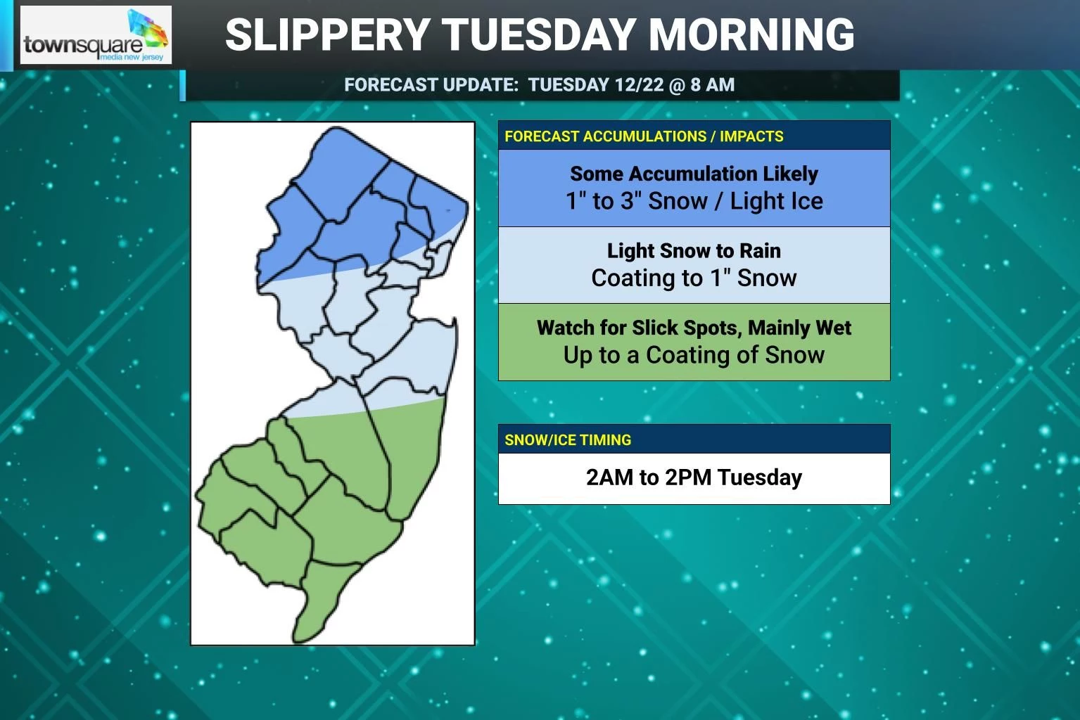
For North Jersey, approximately along and north of Interstate 78, snow will start soonest and hang on longest. If a changeover to wintry mix or rain occurs, it would not be until the storm is winding down around midday Tuesday. So the northwest corner of the state will be home to the most snowfall this time around. I have painted a broad forecast of 1 to 3 inches here. There is also the risk for some freezing rain, causing a light glaze of ice. That is enough to slow down travel due to reduced traction and visibility. If this forecast holds or becomes even snowier, we might see some advisories posted here later on.
For the middle part of the state, from I-78 down to about northern Burlington and Ocean counties, a quick hit of snow around daybreak Monday could stick quickly to cold surfaces. That is why I think it is prudent to forecast a coating to an inch of snow here. "Conversational snow" that likely would not cause significant problems on the roads.
In South Jersey, you may see some snowflakes, but little to no accumulation is expected. Most of what falls from the sky during the daytime hours Tuesday would be liquid rainfall. So don't expect a wintry wonderland here — roads will be wet, not icy.
Action Steps
There is probably very little you have to do to prepare for this storm. Crews will be out brining and salting roads, as pretreated surfaces will fare very well during and after the storm.
I doubt we will see many (if any) school closings or delays on Tuesday.
And most New Jerseyans probably won't need to shovel — as the sun comes out and temperatures warm to near 40 degrees Tuesday afternoon, most of what accumulates in the morning will melt.
What's Next
Christmas Eve Wednesday should be a fairly pleasant day, with partly sunny skies and high temperatures touching the 40s.
Christmas Day Thursday will be cloudier and could feature some spotty showers. While I would love to see some magical Christmas snowflakes falling from the sky, it looks like mainly inconsequential rain showers for now.
I am growing increasingly concerned about Boxing Day Friday, as another clipper system looks to have some teeth and some cold air associated with it. And could be enough to bring more significant snowfall to at least part of New Jersey.
Forecast models are still all over the place in terms of "which part" of New Jersey would likely see the most snow from that system. For now, just know it is something we are watching — and we will continue to dial in the forecast as it gets closer. (It will become especially clearer once Tuesday's storm passes by — stay tuned!)
Glossary of NJ winter weather words and phrases
Gallery Credit: Dan Zarrow
Dan Zarrow is Chief Meteorologist for Townsquare Media New Jersey. Follow him on Facebook for the latest forecast and realtime weather updates.
Christmas snow - When it's happened, and the 2025 odds for NJ
Gallery Credit: Mike Brant
More From New Jersey 101.5 FM


