

Latest update on New Jersey’s upcoming snowy, icy, slushy mess
UPDATE... This article is outdated...
For the latest storm forecast information, please refer to my newest weather blog post.
UPDATE as of 3:30 p.m. Tuesday...
ORIGINAL POST from 7:54 a.m. Tuesday...
The Bottom Line
Monday was a dropdead gorgeous weather day, across New Jersey, as temperatures soared as high as 59 degrees. Not too shabby, considering the day began with a healthy coating of snow on the ground for most of the state.
While Tuesday morning remains mild, it is about time for winter to rear its ugly head again. Tuesday will be a big transition day, as a chilly wind sends temperatures tumbling once again.
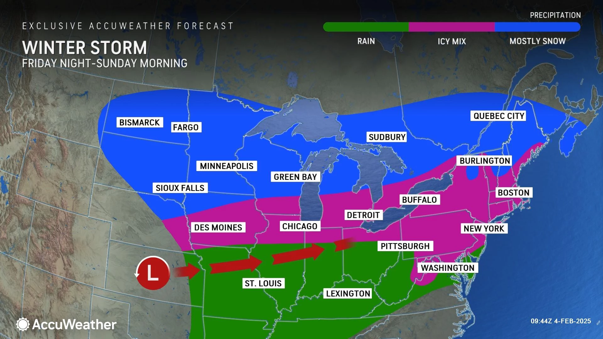
This new intrusion of cold air is the first ingredient for our next storm system, set to arrive late Wednesday. It is not a snow storm. It is not an ice storm. It is not a rain storm. It will be all of the above for New Jersey, depending where you are and what time it is.
Bottom line: While snow accumulations will be limited, the big concern here is a sloppy Thursday morning commute. As the headline of this post suggests, roads will be some combination of snowy, icy, and slushy. (And/or wet too.)
I am largely focused on the timeline, geography, and overall impacts of Wednesday night's storm, and not so much on exact numbers. Yes, I show some approximate snow and ice accumulation values, presented in a "worst case scenario" light. But let's get real — this is a very complicated setup, where one or two degrees on the thermometer will make all the difference in what you see. Blur your eyes reading the forecast, prepare for the worst, and hope for the best.
Oh, by the way ... There is another messy wintry mix storm in the forecast for Saturday.
And then potentially more storm activity next week.

Tuesday
The nice, mild weather has lasted into Tuesday morning, as the entire state of New Jersey begins the day above freezing. As of this writing (7 a.m.), temperatures range from 33 to 51 degrees, north to south. Some spots are above their normal high temperature for this time of year.
We should see plenty of sunshine throughout Tuesday, and our weather should stay dry. But the big weather nuisance of the day will be a brisk, chilly northwesterly wind. Top gusts look to be in the 20 to 30 mph range.
Thermometers should generally hold steady, averaging mid 40s or so, through midday Tuesday. And then temps will start to tumble.
By Tuesday night, we will fall all the way into the lower 20s. Definitely back on the cold side. Definitely back to bundling up by Wednesday morning.
Wednesday
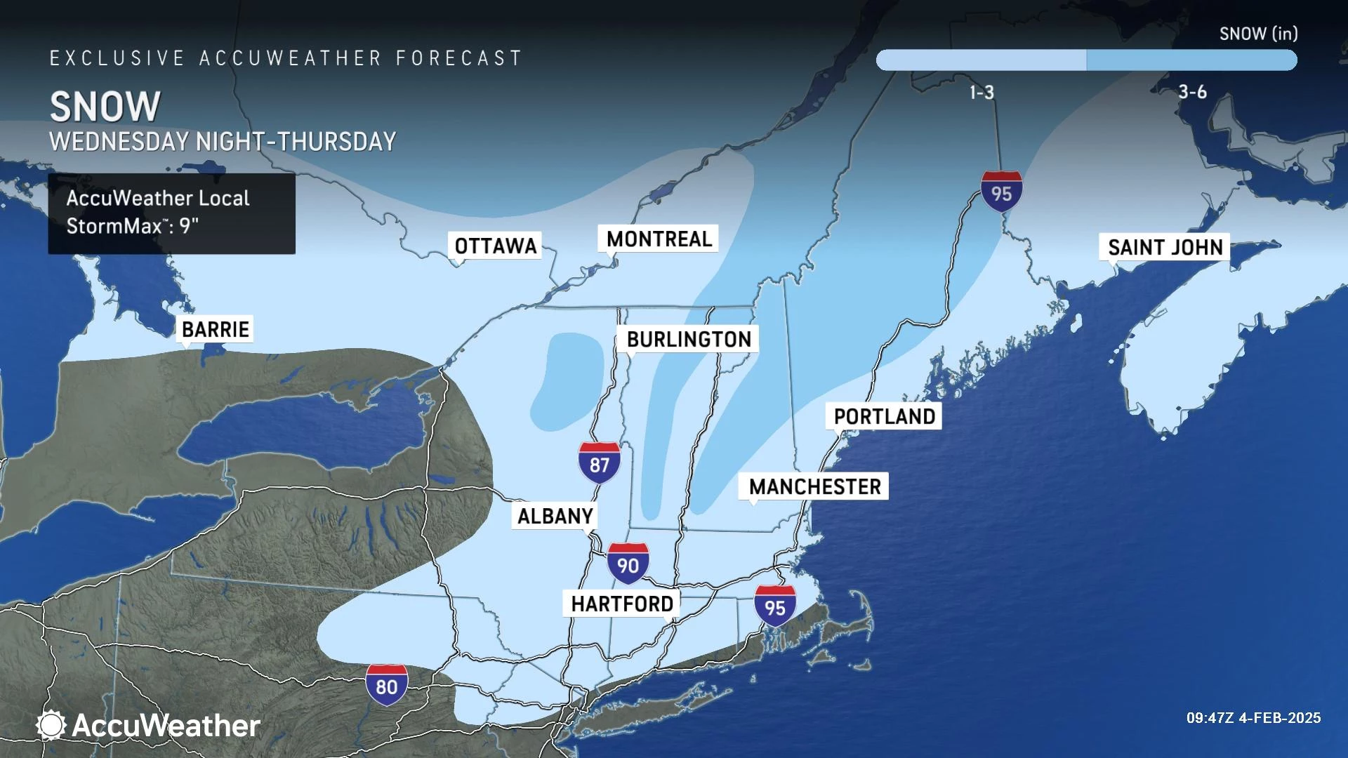
Most of Wednesday will be gray and cold, before our winter storm ramps up at night.
Expect cloudy skies, and high temperatures only around the freezing mark — let's call it 30 to 35 degrees.
There is a chance for a snow shower during the daytime hours Wednesday. In fact, at least one model (the NAM) paints a persistent stripe of light snow over the southern half of the state, which could produce some light accumulations and travel difficulties by the evening commute. (For the record, I do not think this is a likely scenario — just something worth mentioning.)
Widespread inclement weather will not arrive until Wednesday night, likely not until after Midnight. Given temperatures in the 20s and 30s, onset will likely be all light snow.
However, as the storm progresses, warmer air will creep in from the south, especially about a mile above the ground. This is a very important slice of the atmosphere for wintry weather, as it dictates exactly what form of precipitation will fall from the cloud.
For approximately the western half of the state, a transition from snow to icy mix is likely between Midnight and daybreak Thursday. Icy mix consists of mainly sleet and freezing rain — it does not "accumulate" like snow, but can create a very slippery situation.
North Jersey is the most difficult zone to predict here, as precipitation could stay wintry for the duration. But will it be cold enough at all levels for straight snow? Or will mixing inhibit accumulations and enhance the icing potential? In either case, travel conditions will be sloppy Thursday morning — it's just a matter of whether roads become more snowy, icy, or slushy.
Meanwhile, closer to the coast, I suspect a quick flip from snow to straight rain is the most likely scenario. That transition will finish well below the Thursday morning rush hour. Some light accumulation and slick spots are possible, but the ground will quickly turn slushy and/or wet instead.
Here is my first stab at an impact map for this complicated storm system. This incorporates all the potential storm scenarios on the table, giving you an idea of the worst case snowfall/icefall. I tried to split the state into four regions based not on snow/ice accumulation numbers, but rather on precipitation type, what Thursday morning will look like, and how bad travel conditions could get.
Four inches of snow and/or a tenth of an inch of ice would qualify as "moderate" impact. So again, it does not look like a major winter storm. But certainly an impactful one across the entire state.
Thursday
Most of New Jersey will flip to plain rain at some point Thursday morning, before precipitation ends around midday (1 or 2 p.m. at the latest).
For the rest of Thursday, do not expect skies to clear much. Nor any huge warmup, beyond the 30s (north) and 40s (south).
I do not expect any significant lingering wintry impacts into the Thursday evening commute.
Friday
Just like Tuesday. In between storm systems, Friday will be a blustery day with a mild start but a colder finish.
Temperatures will fall from the lower to mid 40s, with a brisk westerly wind. Skies will be partly sunny and weather will stay dry.
Yet another storm system will impact New Jersey this weekend. It looks like another "mess of mixing". And I can guarantee we will not have a solid handle on precipitation types and potential accumulations until the Wednesday-Thursday storm departs. (Following my "one storm at a time" rule.)
A passing shower will be possible to the south Saturday morning, before more widespread precipitation arrives late-day. Once again, weather could lean snowier or icier or wetter, depending on the exact track and temperature profile. Impactful snow and/or ice accumulation is a possibility by the time this thing wraps up Sunday morning around daybreak.
The rest of Sunday looks fine, as does Monday. The next storm system we will have to watch is in the Tuesday-Wednesday time frame. Models have been pretty bull-ish on snowfall totals over the past few runs — it will be interesting to see how that continues to develop and evolve.
Let it snow: 12 things to know about winter forecasting in NJ
Gallery Credit: Dan Zarrow
Dan Zarrow is Chief Meteorologist for Townsquare Media New Jersey. Follow him on Facebook for the latest forecast and realtime weather updates.
Final flakes: When does snow season end in NJ?
Gallery Credit: Dan Zarrow
More From New Jersey 101.5 FM


