
Heat, thunderstorms, and Elsa: Three big weather headlines for NJ this week
UPDATE... This article is outdated...
For your latest tropical storm forecast information, please refer to my newest weather blog post.
UPDATE as of 2 p.m. Tuesday...
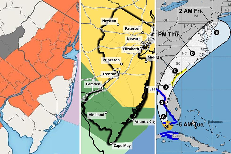
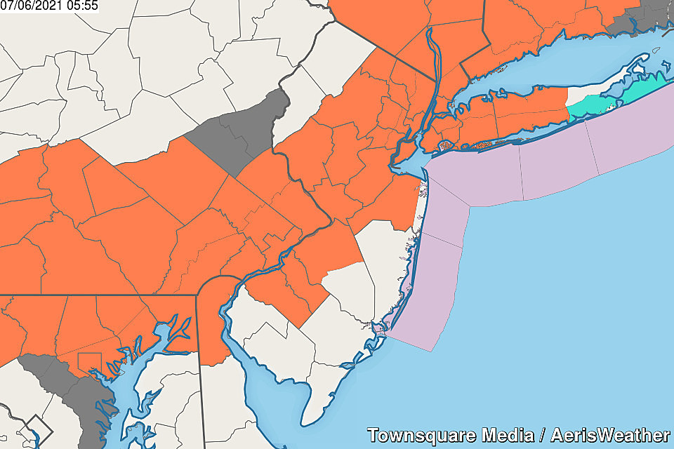
A Severe Thunderstorm Watch has been issued for all 21 counties of New Jersey through 10 p.m.
Given the hot, humid atmosphere, thunderstorm activity will explode from 4 p.m. on. Storms will start in northwestern New Jersey, drifting to the south and east through the evening. Gusty winds and flooding rains will be the primary concerns, along with frequent lightning. Some hail and an isolated tornado can't be ruled out.
I expect storms to largely pulse down as that watch expires at 10 p.m., although residual non-severe thunderstorms and showers are possible through about 2 a.m.
ORIGINAL POST from 6:30 a.m. Tuesday...
The Bottom Line
The long Fourth of July holiday weekend included a mix of weather conditions, ranging from rainy and cool, to stormy, to warm and summerlike. No matter what the skies brought, I hope you had a great holiday.
Back to work on Tuesday, and we're being smacked in the face by three big weather headlines. Intense heat and humidity make a comeback, although only for a couple of days. And with such juicy air, all it will take is a little spark for strong to severe thunderstorms to blossom.
Plus, all eyes are on Tropical Storm Elsa, spinning through the Gulf of Mexico. As a Florida Gulf coast landfall now seems certain, we're getting a clearer picture of Elsa's potential impacts on the Garden State later this week. (Spoiler alert: I'm not overly concerned.)
Heat
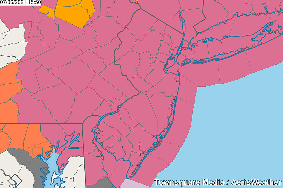
Monday was a phenomenal beach/pool day across New Jersey. And Tuesday will be too - although it will be 5 to 10 degrees hotter. And the rip current risk increases to moderate too.
Even though we did not hit 90 degrees anywhere in New Jersey on Monday, Tuesday will be a very different story. Get ready to sweat as thermometers soar into the lower 90s across most of the state. You'll find some relief at the Jersey Shore, with highs in the 80s.
Dew points have also pushed upward to around 70. That's the benchmark for sticky, steamy weather. So we have to bring the dreaded "heat index" back into the conversation, which will come close to 100 Tuesday afternoon. That heat index factor, also called the "apparent temperature," approximates the effect of both the heat and humidity on the human body.
A Heat Advisory has been issued for much of New Jersey from 11 a.m. Tuesday through 8 p.m. Wednesday.
You know the drill. Dress for the heat, stay extra hydrated, and take frequent breaks to cool down.
Wednesday will likely be just as hot. Temperatures in the lower 90s. Heat index near 100.
Thursday cools down to more seasonable levels, with forecast highs in the mid 80s. 90 is still a possibility somewhere in the state - that would make it three-in-a-row, and an "official" heat wave.
Thunderstorms
I am especially concerned about this piece of the forecast puzzle. The mix of heat and humidity will be just right to make the air extra juicy and literally explosive. (Over 3000 CAPE - that's pretty impressive for the Northeast US!) All it will take is a spark for thunderstorms to blossom and grow rapidly.

The window for strong to severe thunderstorms will be about 4 p.m. to 10 p.m. Tuesday. Fizzling thunderstorms and showers may linger through as late as 2 a.m. Wednesday.
The big concerns will be gusty winds and pockets of very heavy rain. Lots of lightning and small hail are probable too. The shear profile doesn't really lend to twisting action, but I wouldn't rule out a tornado risk.
The only question in my mind is how widespread the storms become. I've settled on "scattered" - with one or two rounds potentially sweeping from northwest to southeast, not everyone will necessarily experience a storm. But if you do, it could be loud and even violent for a brief time.
A few thunderstorms are possible late-day Wednesday too. But I don't think they'll be as widespread or as strong. (In fact, you'll notice I left the thunderstorm icon off my 5 Day Forecast for now.)
Elsa
It's time to get serious about Elsa's potential impacts on the United States and, specifically, New Jersey. (Unfortunately, that means the time for Frozen references and memes has passed.)
As of this writing (5 a.m. Tuesday), Elsa is a tropical storm centered just 65 miles southwest of Key West, Florida. A landfall along Florida's Gulf Coast seems a certainty Wednesday morning. Elsa will then track north and east, disintegrating over land.
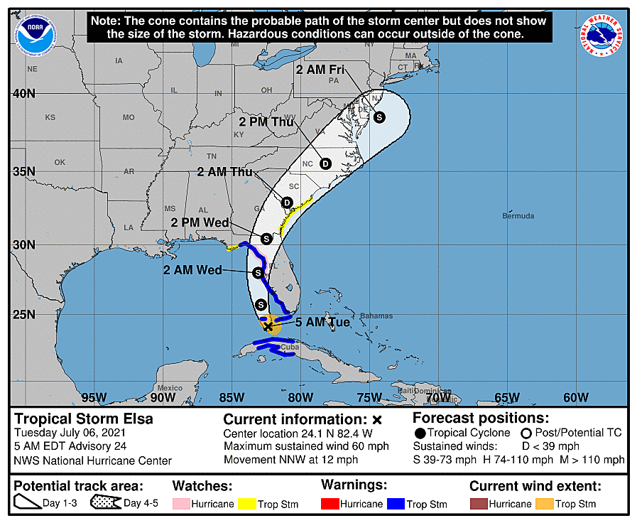
Of course, that track puts Elsa in our neighborhood in the Thursday to Friday time frame, either as a tropical depression or weak tropical storm. (I'm actually surprised the latest NHC forecast shows such fast re-intensification just south of NJ.)
So we do have to carefully consider what weather and surf impacts to expect. There are three reasons why I'm not concerned:
1.) It's not a major hurricane. Storms that "only" reach tropical storm strength can still wreak havoc. However, by the time Elsa gets to NJ, the overall power and tropical nature should be minimal.
2.) The storm is coming from the southwest. Along those lines, tropical storm systems that approach the Jersey Shore from the ocean are precarious, as they maintain their strength and churn up the ocean. (Like Irene, Sandy, Fay, Isaias, etc.) Although this one will cause some degree of rough surf and possibly some coastal flooding, it will be brief and limited.
3.) It looks like a glancing blow. The track of Elsa's center has steadily remained south of NJ for the past several days. Close enough to produce some moderate to heavy rain and marginal wind. (Rainfall totals could reach an inch along the Shore. Wind gusts could hit 30 mph.) However, we have to watch carefully - if the storm wiggles closer to us, the wind and rain impacts could become a bit more serious.
4.) It will be moving quickly. The window for nasty weather will be limited to about 18 hours, from Thursday evening through midday Friday. It will not be an all-day affair. The storm's forward speed will also limit the number of high tide cycles that will run unusually high.
Bottom line: We'll probably see some nasty weather - a breeze and steady rain - and some rough surf. But I see no need to ring loud alarm bells and/or batten down the hatches here in New Jersey just yet.
The Extended Forecast
Once Elsa clears out, skies will clear and we'll enjoy seasonable warmth heading into the second weekend of July.
The next day with a near-zero chance of rain will be Saturday. Good news for the start of the weekend, with sun and clouds and highs in the mid 80s.
However, another batch of wet, unsettled weather with an on-shore breeze is in the forecast for Sunday.
Dan Zarrow is Chief Meteorologist for Townsquare Media New Jersey. Follow him on Facebook or Twitter for the latest forecast and realtime weather updates.
LOOK: Here are the 50 best beach towns in America
Gallery Credit: Keri Wiginton
UP NEXT: See how much gasoline cost the year you started driving
More From New Jersey 101.5 FM


