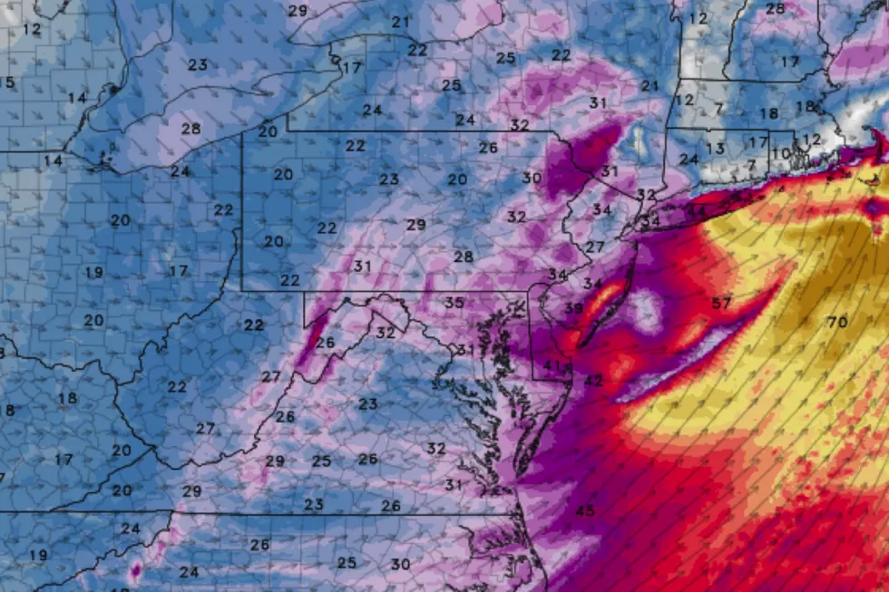
From wet to windy: 40-60 mph gusts Friday, as temperatures tumble
TORNADO WARNING in effect until 10:15 a.m. for northwestern Gloucester and northwestern Salem counties. A severe thunderstorm capable of producing a tornado was located over Elsmere, or over Wilmington, moving northeast at 50 mph.
Oh boy! After an active weather week, Mother Nature is throwing a lot of weather at New Jersey Friday. We start with the continuation of soggy weather. But a bigger concern — wind — will be with us too. And that "whoosh" of colder air will lead to temperatures nosediving by the end of the day.
Timeline
Here is the order of weather events as they will occur Friday:
—Friday Early Morning... As of this writing (5:30 a.m.) radar is pretty quiet. Even though we're in a break in rainfall, it's damp and drizzly, cloudy and generally cool (lower 30s north, lower 40s central, lower 50s south). There are pockets of pretty thick fog, with visibility as low as a quarter-mile.
—Friday Mid Morning... Westerly wind starts to kick up. Gusts between 40 and 60 mph are likely, with the fiercest winds expected along the Jersey Shore.
—Friday Late Morning... One more batch of scattered rain pushes through New Jersey, mainly north and central.
—Friday Midday... The highest wind gusts of the day are expected between about 10 a.m. and 2 p.m. We'll also reach our high temperature around lunchtime (upper 40s north, upper 50s central, lower 60s south).
—Friday Early Afternoon... Still a few hit-or-miss showers possible. Maybe even some snowflakes in northern New Jersey, as colder air arrives.
—Friday Late Afternoon... Thermometers falling fast, as colder, drier air arrives.
—Friday Evening... Weather dries out. Skies clear. And the wind dies down a bit. It will be breezy and cold overnight, with lows in the mid 20s and a wind chill ("feels like" or "apparent" temperature) in the teens. Yes, it's about to feel like February once again.
Advisories
Our previous Flood Watch was cancelled early, as the axis of heaviest rain managed to miss the Garden State on Thursday. We do have two new advisory headlines related to wind.
—High Wind Warning... 8 a.m. to 7 p.m. Friday... Monmouth, Ocean, SE Burlington, Atlantic, and Cape May counties.
—Wind Advisory... 8 a.m. to 7 p.m. Friday... NE Burlington, Camden, Cumberland, Gloucester, Hunterdon, Mercer, Middlesex, Morris, Salem, Somerset, Sussex, and Warren counties.
—Wind Advisory... 1 p.m. to 7 p.m. Friday... Bergen, Essex, Hudson, Passaic, and Union counties.
The Rest of the Forecast
We move into the weekend with a return to seasonably chilly weather. For the record, only one day (January 30) in the last two and a half weeks (since January 22) has featured at- or below-normal temperatures.
Saturday will be calm and dry, with plenty of bright sunshine. I've been able to warm our forecast slightly, with highs near 40 degrees.
We're still watching the chance for a snow or rain shower from late Saturday night through Sunday morning. But it still looks inconsequential. The rest of Sunday looks fine, with a mix of sun and clouds and highs in the lower to (maybe) mid 40s.
Unfortunately, we can't get used to the quiet, dry, almost-pleasant weather. Early next week, a slow-moving front will introduce another extended chance of rain. That wet weather doesn't look heavy or continuous, but I do have to keep rain chances in the forecast from Monday morning through Tuesday night.
We'll have to monitor temperatures very carefully during that time. Models suggest the chance for a quick hit of snow in North Jersey at onset early Monday morning. And again for everyone as things wrap up late Tuesday night. My current sense is that accumulations are unlikely.
Monday's high temperatures look to briefly pop into the 50s. Then we fall off into the 40s for the rest of the week.
Stay safe and don't get blown away in those ferocious winds. Have a great weekend!
More From New Jersey 101.5 FM


