
Cold air has returned to NJ, now let’s talk about snow (and rain)
The Bottom Line
So far, the month of November has been quite warm. With the exception of one day — last Wednesday — temperatures every day have risen well above normal.
Now, the pendulum has swung in the other direction. Cold air has finally invaded New Jersey (and really, the entire continental United States). So temperatures will end up firmly below normal for the foreseeable future.
In addition, we are watching our next storm system, set to arrive Tuesday evening. And yes, given the colder air, there is a chance for snowflakes and ice pellets. However, the threat of wintry mix and slippery spots is very limited.
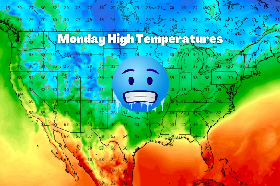
Monday
Not only is it Monday. Not only are students and teachers (and some meteorologists) heading back to work/school after a long weekend. But it's cold out there.
Temperatures to start Monday morning are mainly in the 30s, with a couple of 40s along the Cape May peninsula. You'll be reaching for a jacket and/or sweater, and you might want to warm up the car a bit.
Normal high temperatures for mid November are in the mid 50s. Today's highs will only reach the mid 40s — more typical for the middle of December.
With high pressure in control of our atmosphere, we'll see mostly sunny skies, dry weather, and (very) dry air.
Most of Monday night should remain clear. It will be a frosty-freezy night, away from the immediate coast. Most low temperatures will dip into the lower to mid 30s. The coldest corners of the state will dip into the 20s.

Tuesday
The day will start quiet, and then we get soaked. (And some in NJ will get snowed on.)
Skies will progress from sun to clouds on Tuesday. High temperatures will reach about 45 to 50 degrees — pretty similar to Monday.
A rain shower may creep in starting Tuesday afternoon, after about 1 p.m. But the "main event" of our next storm system will drive in Tuesday evening, after about 5 p.m.
A period of steady to heavy rain looks likely for most of New Jersey through Tuesday night. Rainfall totals will likely average one inch across the state — that's some healthy wet weather. I don't think flooding will be a concern. A few rumbles of thunder is possible, especially along the southern coast.
In northwestern New Jersey, temperatures both at the surface and aloft will allow for some mixing of snowflakes and ice pellets. But again, the wintry weather potential is limited, in several ways:
—Limited in geography... Only Sussex, Warren, Morris, and western Passaic counties are expected to see a period of wintry/ice mix.
—Limited in time... Temperatures will rise Tursday night, meaning wintry mix will flip to plain rain after just a few hours.
Could there be some slippery spots for a time Tuesday evening? Sure. But again, only in far North Jersey.
Is there a snowier solution on the table? I don't think so — those snowflakes are really going to be fighting a relatively warm ground and warming air temperatures.
Bottom line: Expect a wet — not icy — Wednesday morning commute.
Wednesday
Rain will be wrapping up Wednesday morning. Most of the state will see raindrops end by about 8 a.m. Northeastern NJ could stay damp n' dreary until late morning — let's say 11 a.m.
Partial clearing will take over through Wednesday afternoon. It will be breezy and almost mild, with highs temperatures on either side of 50 degrees. It's going to be the "warmest" day of the week, so soak in what you can.
Thursday
Back to cool, crisp, December-ish weather. We should see a lot of sunshine on Thursday, with some fair weather clouds. And again, the day should be dry. (I can't rule out a flurry creeping into NW NJ.)
High temperatures will scale back to the mid 40s Thursday afternoon. While that would be a "nice day" in the middle of winter, it is decidedly below normal for mid-November.
Friday & Beyond
Quiet weather continues into the weekend. But, believe it or not, temperatures are only going to get colder.
Highs will only reach the lower 40s Friday. Saturday will be the bottom of the barrel — 20s in the morning, and possibly only upper 30s on Saturday. Plus, it's going to be breezy, keeping the wind chill even colder. I'm not sure we're ready for such blustery, cold weather!
Sunday looks better, as temperatures return to the 40s.
Temperatures may moderate further around Thanksgiving. (Yes, Thanksgiving is coming up next week.) But I have a feeling we are done with 70s and 80s for a long, long time.
The Winter Solstice is only 37 days away.
Dan Zarrow is Chief Meteorologist for Townsquare Media New Jersey. Follow him on Facebook or Twitter for the latest forecast and realtime weather updates.
25 costliest hurricanes of all time
LOOK: The most expensive weather and climate disasters in recent decades
Gallery Credit: KATELYN LEBOFF
More From New Jersey 101.5 FM


