
A snowy, icy, wintry mess Thursday-Friday: Latest timing, totals, impacts for NJ
UPDATE... This article is outdated...
For the latest winter storm forecast information, please refer to my newest weather blog post.
New Jersey's 7th winter storm of the month of February is now arriving. Let's keep things really simple for this final update for Thursday-Friday's wintry mess. Let's run through the forecast via a set of simple, easy-to-skim statements, so you know what to expect and can plan your day(s) accordingly.
The Bottom Line
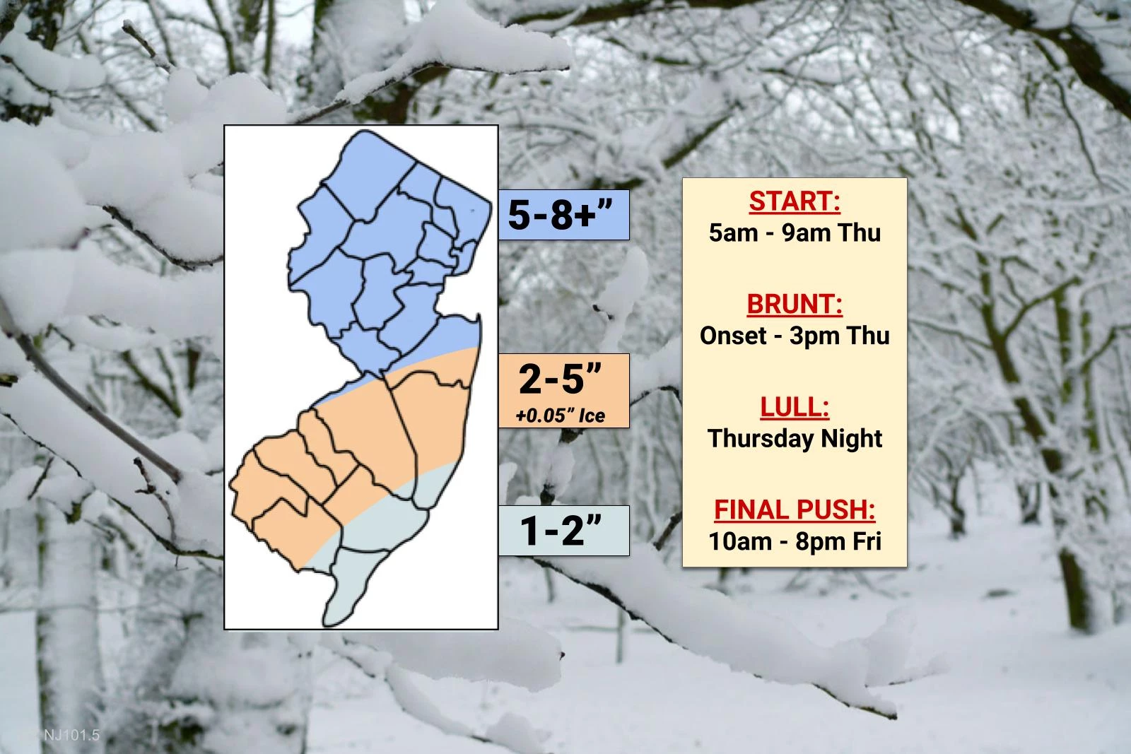
While not a blockbuster, historic, bread-and-milk kind of storm, all of New Jersey is facing snow and icy mix during the daytime hours Thursday, leading to rapidly deteriorating travel conditions.
Ch-Ch-Ch-Ch-Ch-Changes
I made exactly two tweaks to my forecast early this morning. 1.) I downgraded my snow totals slightly to better match model trends and my gut feeling about snow vs. sleet. 2.) I shifted part of Monmouth County to a higher snow band given initial radar trends. Along the mindset of "keeping things simple," I opted to keep only three colors on my final snow/impacts map, differentiating between significant "mainly snow" impacts, the "snow and sleet" zone, and the "snowy and rainy" southern coast.
Snowy Start
As of this writing, it's already snowing across most of the state. Through about 9 a.m. Thursday morning, snow will fill in across the entire state.
The Brunt of the Storm
Snow will quickly become moderate to heavy, through about 3 p.m. Thursday afternoon. About 75% of our total snowfall will occur during this window.
A Noticeable Lull
From Thursday late afternoon through the evening and overnight hours, precipitation intensity will lighten up considerably and become more scattered.
The Final Push of Snow
It's not over yet! The storm will still be with us for most of Friday, with a last surge of snow (and possible 1-2" accumulations) from Friday late morning through early evening. Final flakes are expected by around 8 p.m. Friday.
The Sleet Factor
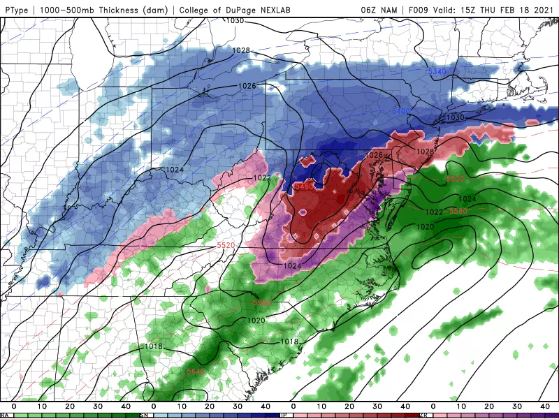
As the mid levels of the atmosphere warm, snowflakes will mix with and transition to an icy mix of snow, sleet, and rain across approximately the southern half of the state by around midday. (The "orange" and "light blue" areas of my map above.) This area will keep seeing some degree of "wintry mix" (rather than straight snow) until early Friday, at least. The immediate southern coast will likely flip to plain rain at some point. Since ice pellets (sleet) are more dense than snow, it does not accumulate as efficiently. It's still going to be a slushy, icy mess — and shoveling that mess will be no fun at all.
Accumulations
While my time and forecast confidence are just too limited this morning to put together a full "county by county" forecast, here is a quick breakdown of snow accumulations across the state (generally following the snow map I pasted above):
—Atlantic County... 1" coast, 3" west
—Bergen County... 5-7"
—Burlington County... 2" coast, 5" west
—Camden County... 3-5"
—Cape May County... 1-2"
—Cumberland County... 2-4"
—Essex County... 5-7"
—Gloucester County... 3-5"
—Hudson County... 5-7"
—Hunterdon County... 6-8"
—Mercer County... 6-8"
—Middlesex County... 6-8"
—Monmouth County... 4" coast, up to 8" inland
—Morris County... 4-7"
—Ocean County... 2" coast, 4" inland
—Passaic County... 4-6"
—Salem County... 3-5"
—Somerset County... 5-8"
—Sussex County... 4-6"
—Union County... 5-8"
—Warren County... 4-6"
I included a "plus" on my snow map, to indicate that north-central New Jersey could see a few snowfall totals as high as 10 inches.
Also keep in mind, light to moderate icing (due to sleet and freezing) is a concern for the southern half of the state. That's the "orange" and "light blue" zones on my map above.
Coastal Flooding
Not a huge concern this time around, I'm happy to say. But on Friday, up to an extra foot of water in tidal waterways could cause minor flooding, especially in vulnerable areas that tend to flood with every storm.
Warnings
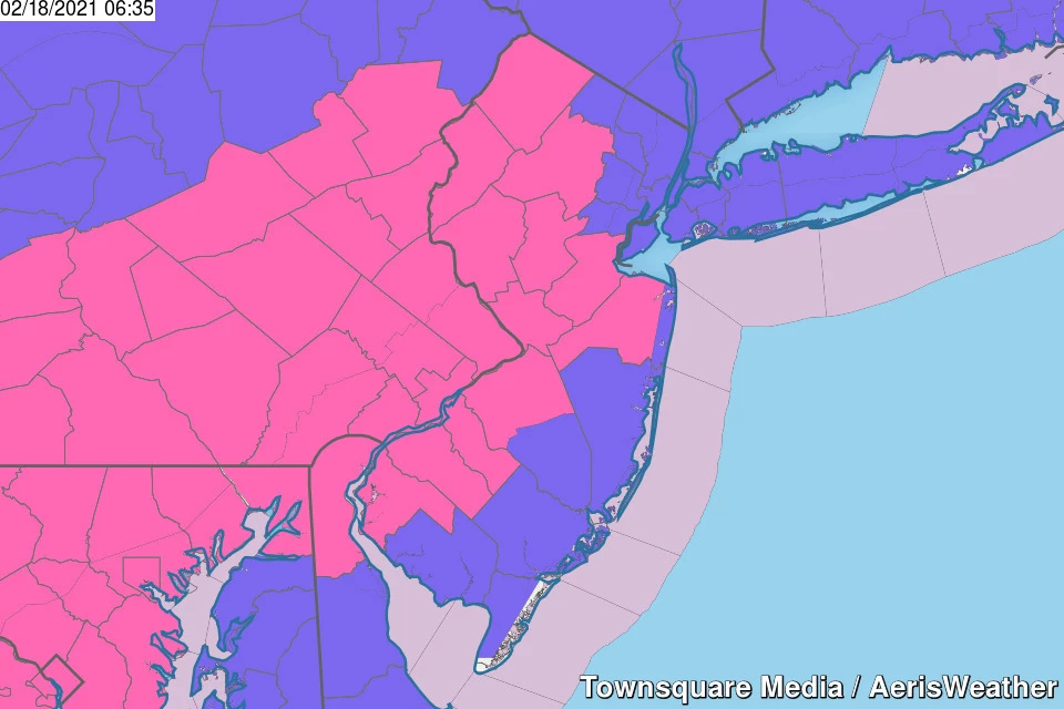
A Winter Storm Warning is in effect for NW Burlington, Camden, Gloucester, Hunterdon, Mercer, Middlesex, inland Monmouth, Salem, Somerset, Sussex, and Warren counties until 10 a.m. Friday.
A less-severe Winter Weather Advisory covers almost the rest of the state through Friday.
There are no advisories at this time for coastal Cape May County.
The Extended Forecast
After the storm wraps up, our weather pattern will finally quiet down. There are no big storms on the horizon.
The weekend will be sunny and dry, but cold. Highs will only reach the mid 30s, with a stiff breeze adding a bite to the air on Saturday.
Our next storm system will arrive Monday afternoon. It's a fast-moving clipper system, that will drop some snow over North Jersey and rain over South Jersey. About an inch of accumulation is possible — not a big deal, but possibly enough to slicken up the roads a bit for Monday evening's commute.
We're On the Air!
We'll be on your radio and computer with the very latest storm information all day, all night, and throughout Friday too. Be smart, stay safe, and keep warm out there!
Dan Zarrow is Chief Meteorologist for Townsquare Media New Jersey. Follow him on Facebook or Twitter for the latest forecast and realtime weather updates.
MORE: What is the difference between sleet and freezing rain, anyway?
More From New Jersey 101.5 FM


