

Waves of showers and clouds for NJ Friday, better weekend weather
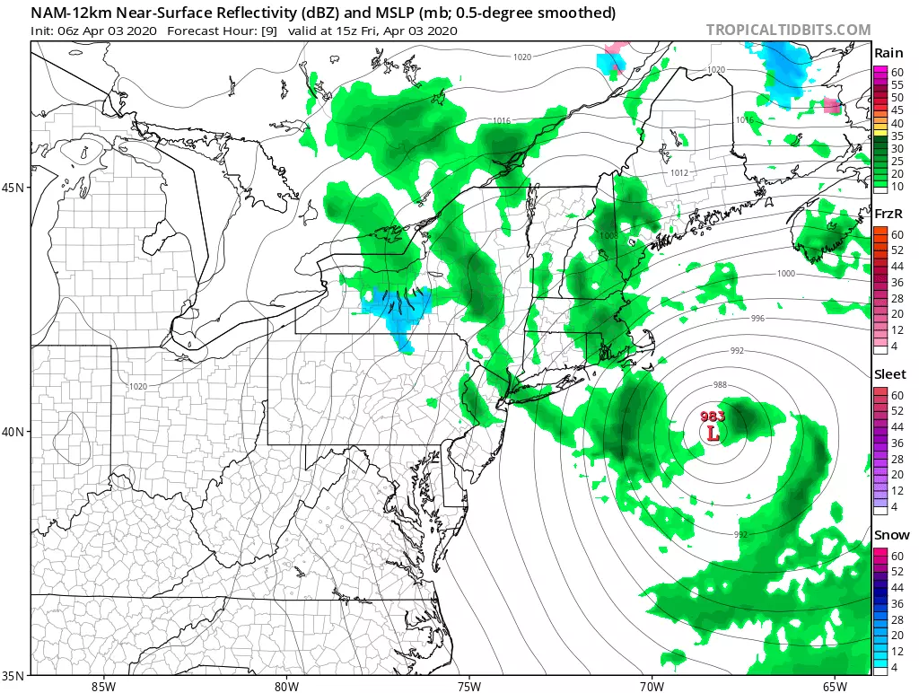
We find ourselves on the western edge of a powerful coastal storm system. That will spit rain showers and clouds toward New Jersey throughout the day, marking a return to damp and grey weather. Not a washout, but not entirely pleasant either. The weekend looks better, although again not exactly perfect.
On this Friday morning, we're already seeing some showers licking the eastern edge of New Jersey. The coast will likely be the wettest part of the state here. It will remain cloudy and breezy all day, with wind gusts between 20 and 30 mph. (On Thursday, we had several wind gusts over 40 mph. A 52 mph gust was reported at the top of High Point.)
Temperatures are averaging upper 40s early, and we'll only see lower 50s at best Friday afternoon.
I have to keep the chance for scattered showers alive until late Friday evening. And then we'll dry out with calming winds overnight. Low temperatures will fall into the lower 40s.
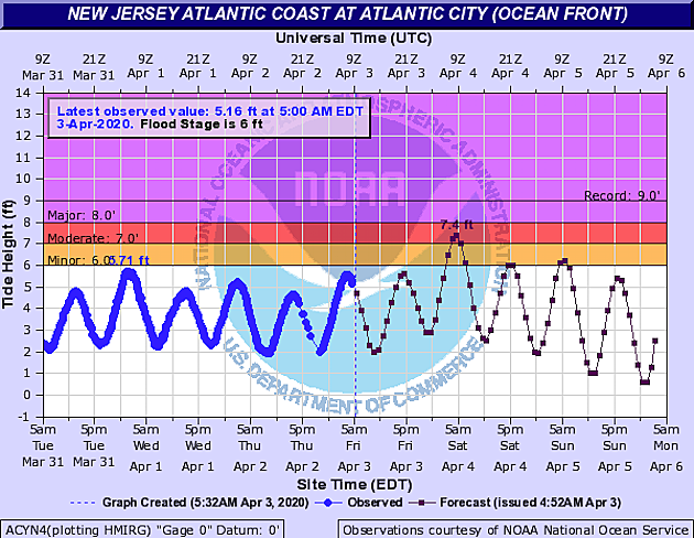
This weekend, we will have to closely watch the ocean and bays. The aforementioned coastal storm system will drive some water toward the Jersey Shore, potentially causing minor to moderate flooding of tidal waterways. I generally call this "the usual spots" — not that you're going to the beach this weekend, of course. The most precarious high tide cycle will be early Saturday morning.
Otherwise, Saturday won't be terrible. Skies will be mostly cloudy, but that descriptor allows for some peeks of sunshine. And it will be mainly dry, although a sprinkle will be possible at any time. High temperatures will improve to the seasonable mid 50s Saturday afternoon. Cooler along the coast, closer to 50.
Sunday will start somewhat brighter, with early breaks of sun. But clouds will return soon enough, with a late-day shower chance too. (That's Sunday late afternoon to Sunday early evening.) High temperatures will bump to around 60 degrees, thanks to a southerly wind. That is only an on-shore direction for NJ's southern coast, so even coastal Monmouth and Ocean counties will come close to that 60-degree mark.
I am loving how Monday's forecast has evolved, as it now looks like the nicest day of the week. Partly to mostly sunny skies. Light winds. Dry weather (probably). And highs in the lower to mid 60s. Nice!
The forecast goes low-confidence through the middle of next week — Tuesday, Wednesday, and Thursday. There will be some rain in there, especially on Wednesday. (Maybe even some thunder.) Temperatures may hit 70, especially on Tuesday. But equally, highs could get stuck in the 40s. A lot of factors and model solutions in play here. We'll figure out those details over the next few days.
I will say that long-range models show more sustained warmth arriving by the midpoint of April. How great would it be to get an extended streak of 70+ degree temperatures and sunshine?!
Have a great weekend. Stay safe and stay healthy, New Jersey!
Dan Zarrow is Chief Meteorologist for Townsquare Media New Jersey. Follow him on Facebook or Twitter for the latest forecast and realtime weather updates.
More From New Jersey 101.5 FM


