NJ’s biggest snow and ice storm in years is coming this weekend
UPDATE... This article is outdated...
For the latest winter storm forecast information, please refer to my newest weather blog post.
About This Update
The purpose of this article is to issue my first call snowfall totals forecast for Sunday's winter storm. Therefore, I am not including a comprehensive discussion of the storm's impacts — just a quick rundown of bullet points behind my latest thinking. For the full forecast, including a look before and after the storm, check out my Thursday morning weather blog post: NJ weather: Very cold air, heavy snow and ice return this weekend.
As for the snow map, it is almost exactly the same as the "impacts map" with a few tweaks to the lines and different colors. I had numbers in mind when I drew the map this morning, and opted to use those exact forecast ranges for this first public map this afternoon.
FYI, I believe this is the first time since 2021 I have forecast widespread foot-plus snow in New Jersey. And statewide, this will probably be our most impactful winter storm since the 30" monster Blizzard of 2016.
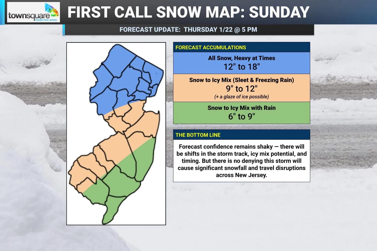
Snow Totals: The Low End (Green / Southeast)
Traditionally, winter storms produce lower snow totals along the Jersey Shore due to the influence of warmer marine air, causing a warmer ground and/or transition to more of a wintry mix than straight snow. That will be the case eventually with this storm. But not to start.
It is going to snow hard for several hours Sunday morning. And because it's going to be so ridiculously cold Saturday and Saturday night, that snow will stick to the ground immediately. That is why I remain confident that 6 inches of snow will accumulate even for coastal areas.
Eventually a changeover to icy mix and even plain rain will likely halt those accumulations through Sunday afternoon and evening. Having said that, 6 to 9 inches of snow still represents a major category winter storm for all points along the Jersey Shore.
Also, I did not include Monmouth County in this lowest color contour because I have this personal theory that Monmouth County always overperforms in winter storms. Often, that is where the statewide maximum snow total occurs, oddly enough. (Latest forecast models also show this could be the dividing line between rain and icy mix.) So I put the intersection of my low and medium contours right on the Monmouth-Ocean county line, at least for now.
Snow Totals: The Middle (Orange / Southwest & Central)
The greatest uncertainty of this forecast at the moment is right here, in the orange area of my map. That is because I can not tell for sure how far west and how far north warmer air will penetrate aloft, causing a period of sleet and/or freezing rain.
If it happens Sunday afternoon and evening, these final accumulations of less than a foot will be spot on.
If the forecast shifts colder, and this region stays all snow through Sunday night, I will push accumulations to over a foot in a heartbeat.
Snow Totals: The High End (Blue / North)
It's going to snow and snow and snow some more. North of the Raritan River looks like the sweet spot for deep snow accumulations, on the order of a foot-plus. Temperatures will be cold, in the 20s, for the duration. That not only means that icy mix stays to the south. But also the snow-water ratio will be high — yielding a dry, fluffy snow that accumulates quickly.
I have to admit: The maximum of 18" is a shot in the dark. I debated going with 16 or 18 or 20 or just putting a "plus sign" on the forecast. But I'll go with the classic 12 to 18 inches for now. Besides, once snow totals are in the double digits, does the exact number really matter at that point?
My only hesitation here is if the storm track makes a significant jog back to the south, which could accordingly shift this "sweet spot" south too. Just like the Blizzard of 2016 — most of New Jersey got a foot or two of snow, but High Point in Sussex County saw a measly four inches.

Timing
I have decided that I just can not pinpoint a "brunt" of this storm. Sunday is just going to stink from start to finish.
After first snowflakes around Midnight Sunday morning, it may take some time for the air to saturate enough for steady snow to take over. But by daybreak Sunday, I think we are going to see bands of steady to heavy snow take over the state. For several hours from Sunday morning through midday, portions of New Jersey could experience inch an hour (or more) accumulations.
And then icy mix gets involves for southern, coastal, and (maybe) central New Jersey from Sunday afternoon into Sunday evening. That will halt accumulates, but conditions will still be very sloppy.
While the storm simmers down Sunday night, don't count out light snow and continued light accumulations until about lunchtime on Monday. (Yes, there will be many school closings and delayed openings around the state on Monday!)
Winter Storm Watch
As expected, the Winter Storm Watch has been expanded to now include all 21 counties of New Jersey. Once hazardous travel impacts are within about 24 hours, this will likely be upgraded to a warning.
Cold Weather Advisory
Don't sleep on the extreme cold that will come before the winter storm. A Cold Weather Advisory has been issued for Friday night through Saturday morning — our second such alert of the week.
This arctic blast is going to be brutal. And yes, potentially dangerous. Morning low temperatures will be in the single digits. With a brisk wind up to 20 mph, the wind chill will plunge to as cold as -10 degrees.
High temperatures on Saturday will only reach the upper teens or so. A frigid start to a wintry weekend.
What's Next?
I will have another weather blog forecast update Friday morning, around the 8 a.m. hour. Plus on-air weathercast updates all day long as usual.
We have already started putting together our coverage plan for the weekend, to help keep you informed and safe. I will have another forecast update Saturday morning, and then will be live in-studio all day Sunday with nowcasting updates as the storm rages on.
The Blizzard of '96 Revisited: Snow totals for every NJ county
Gallery Credit: Joe Votruba
Dan Zarrow is Chief Meteorologist for Townsquare Media New Jersey. Follow him on Facebook for the latest forecast and realtime weather updates.
Final flakes: When does snow season end in NJ?
Gallery Credit: Dan Zarrow
More From New Jersey 101.5 FM