

NJ weather: Trading sunshine for clouds, raindrops, and 50s
The Bottom Line
The past five consecutive days have featured chilly mornings, abundant sunshine, dry weather, and comfortable afternoons. Finally, a nice stretch of weather, after a lousy January.
We do have some changes in New Jersey's near future, as temperatures, cloud cover, and rain chances increase through the rest of this week. Even though we're losing the spectacular sunshine, there is still a lot to like in the forecast with mild 50s on the way. The only potential hiccup to outdoor plans will be spotty rain showers around the Garden State on Saturday.
We are also keeping an eye on a storm system set to arrive early next week, alongside a batch of fresh cold air. Although it is still too early for details, there is a reasonable chance for some accumulating snow in New Jersey. For now, let's game out some potential scenarios for Monday night into Tuesday, ranging from rainy to snowy.

Thursday
The first half of Thursday will feature more bright sunshine, with some thin wispy clouds streaking across the sky. Cloud cover will gradually increase through Thursday afternoon. But it will stay dry and pleasant, mild and problem-free.

It is another chilly February morning, with temperatures averaging 30 degrees around New Jersey. Highs will reach about 50 degrees. That is a few degrees warmer than Wednesday, and definitively above-normal for early February.
Thursday night will be partly cloudy, with lows in the mid 30s. That will be noticeably warmer than the night before. I believe a good chunk of NJ will stay above freezing overnight.
Friday
A hint of March-like weather.
Highs on Friday will hit about 50 to 55 degrees, amid alternating periods of clouds and sunshine. I do have to include a chance of a sprinkle, especially in the morning hours. But do not let that interfere in your plans for the day — that very light, very scattered rain will not amount to much. It will still be a lovely day overall.
Saturday
Saturday turns even more unsettled, carrying the highest rain chance of the weekend. But it will also be the warmest day of the week.

Spotty rain showers look likely, centered on the Saturday midday hours. So you may encounter an hour or two or light rain and damp conditions. Nothing heavy. And definitely not an all-day thing.
Meanwhile, skies will stay mostly cloudy or overcast. High temperatures should hit about 55 to 60 degrees. Not breaking any records, but such temperatures are more typical in early April than early February.
Sunday
Sunday will be slightly cooler and cloudier than Saturday. But rain chances will be considerably lower. Again, this forecast is all about trade-offs.
An isolated rain shower is possible on Sunday, mainly along the southern edge of New Jersey. The rest of the state and the rest of the day will be pretty cloudy. Under the influence of a slightly cooler air mass, high temperatures on Sunday will come down a smidgen, to around 50 degrees. I would still call that "mild" — still above seasonal normals for early-mid February.
Monday & Beyond
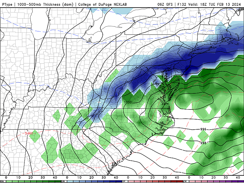
This part of the forecast is focused on a storm system that will sweep across New Jersey early next week. As we discussed previously, confidence is good that we are going to see some sort of storm. The timing picture is coming into better focus too, with impacts expected in the Monday night to Tuesday time frame.
Beyond that, forecast models are still all over the place in terms of 1.) the duration of the storm, 2.) the storm track, and 3.) precipitation types. If the center of low pressure tracks farther north, we end up on the warm side of the storm, forcing a "mainly rain" situation. If the low tracks to the south, there will be a colder sweet spot with "mainly snow".

Because of that uncertainty, it is still too early to start talking specifics. For now let me break down the possibilities further, by laying out three potential storm scenarios.
Scenario #1: Quick Hit of Rain then Snow...
This is the solution currently favored by the European model. Scattered rain would roll in Monday evening, wrapping up with a quick hit of snow Tuesday morning. Colder NW NJ could see up to 3 inches of accumulation, with little to nothing on the ground south of Interstate 80. A classic "nothing burger" of a storm for most of New Jersey.
Scenario #2: Moderately Messy, Rain to Accumulating Snow...
This kind of result is currently favored by both the GFS and Euro ensemble model suites. In my mind, this scenario probably ekes out #1 as most likely, but only barely. Rain Monday evening would again transition to snow by Tuesday morning. But it would linger for a bit during the day on Tuesday, as colder air works in. This would result in widespread snowfall, with minor to moderate accumulations. Perhaps on the order of 2 to 4 inches across the state.

Scenario #3: A Big Thumping...
This burial-by-snow situation is currently favored by the GFS model. This is the least likely of these three scenarios, but still one to consider if more model guidance trends in a colder, snowier direction. A quick hit of rain Monday night would be followed by a strong push of cold air, forcing a transition to heavy snow during the day on Tuesday. Both the Tuesday morning and evening commutes would be significantly impacted by wintry conditions. In a perfect situation, snowfall totals could exceed 6 inches.
If this storm does turn into a "thing" for New Jersey, we will start talking about serious details over the weekend. Beyond the storm, sustained cold looks to take over through the second half of February. So, until then, enjoy the relatively warm and pleasant weather while it lasts!
QUIZ: Can you identify 50 famous companies by their logos?
Dan Zarrow is Chief Meteorologist for Townsquare Media New Jersey. Follow him on Facebook for the latest forecast and realtime weather updates.
LOOK: 50 Famous brands that no longer exist
Gallery Credit: Liz Barrett Foster
More From New Jersey 101.5 FM


