

All ingredients seem to be coming together for ‘big snow’ Sunday in NJ
UPDATE... This article is outdated...
For the latest winter storm forecast information, please refer to my newest weather blog post.
Wednesday morning is ridiculously cold, with most temperatures in the single digits. At least the wind is calm, so we don't have to talk about a biting wind chill or "dangerous" cold this time around. And Wednesday afternoon will get better, as thermometers rise into the 30s. We will see increasing clouds and a chance for an evening snow shower, with little to no accumulation expected. Thursday is going to be a glorious mild day — the only one of the week — with highs in the 40s. And then temperatures crash again on Friday, with highs in the 30s. We're back in the freezer on Saturday, with morning lows in the singles and afternoon highs in the upper teens. And then Sunday is our potential snow storm day, possibly lingering into early Monday.

Two-Day Thaw
There's not denying that Wednesday morning is really cold. I've seen the temperature — not the wind chill, the actual air temperature — as low as -12 degrees in far northwestern New Jersey. Cities and coastal areas are a little more insulated, closer to 20 degrees to start the day. According to my quick research, this may be New Jersey's coldest morning in about 8 years!
The afternoon will fare better though. High temperatures should reach the mid 30s. That is still below normal for late January, but a full 10 degrees warmer than Tuesday afternoon. Winds will stay relatively light. We will see lots of sunshine early on, before scattered clouds build through the afternoon.
A cluster of snow showers will try to drive through New Jersey Wednesday evening, but they will largely fizzle in our very dry air. The best chance to see some snowflakes will be to the north and west. I will even say a dusting of accumulation is possible, but nothing more than that. Temperatures will only fall a few degrees overnight, into the lower 30s — a full 30 degrees warmer than the night prior.
Thursday will easily be the warmest day of the week, with highs in the mid 40s. (Some models even put a 50-degree reading or two in South Jersey.) Skies will stay partly sunny.
Frigid Air Returns
Friday turns the other direction. Skies will progress from mostly cloudy to overcast. A brisk wind will kick up in the afternoon and evening hours, possibly gusting to 30 mph. And temperatures will turn colder again, with highs retreating to the mid 30s (similar to Wednesday).
By Saturday, we are back into the arctic. And possibly back into "dangerous cold" territory. Morning lows will be in the single digits, with wind chills potentially well below zero. Afternoon highs are forecast to only reach the upper teens. My math shows a wind chill around 5 throughout the day. That is face-burning, bone-chilling, teeth-chattering cold.
Sunday Storm: Bottom Line
By now, I am sure you have heard a large storm system complex will affect much of the southern and eastern United States this weekend with inclement, potentially wintry weather. And yes, that includes New Jersey. As always, we have to play out this forecast very slowly and carefully. Especially since it has been a long time since New Jersey has had a major winter storm — all the pieces have to come together perfectly before I pull the trigger on forecasting dramatic snow totals.
We are not there yet. It is still too early to put numbers and details on this forecast, with many variables to consider and so many hours between now and the storm.
But even I will fully admit that confidence is increasing that we will see a significant storm in the neighborhood this weekend. The storm timeline is still centered on Sunday, although I am unsure whether the brunt of the storm (heaviest stuff) would be in the morning or the afternoon. I am also unsure whether flakes would start as early as Saturday night, and/or if the storm could linger into Monday too.
You may recall in Tuesday morning's weather blog post, I gave the ridiculous suggestion that the approximate range of all forecast models was something like 0 to 20 inches. I want to update that fuzzy forecast, given the latest model trends. Let's call it 8 to 28 inches. Still a very wide range of possibilities. But ahhh, notice both numbers went up. Zero is notably no longer a possibility. Did you notice that both the minimum and maximum snowfall numbers are in the "major snowfall" range? This is getting serious — and potentially exciting for snow lovers of New Jersey?
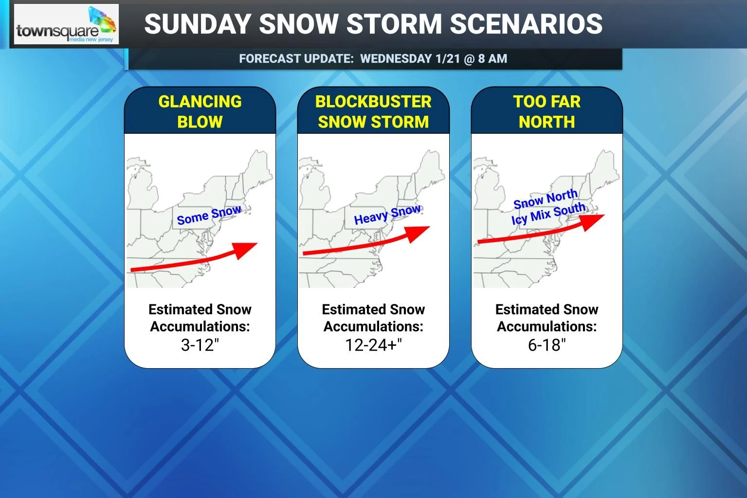
Let me lay out some scenarios that could play out on Sunday, including some ballpark round-number potential snowfall accumulations for each.
Sunday Storm Scenario #0: Complete Miss
I've labeled this scenario as "number zero" and left it off my feature graphic, because I believe it is the most unlikely of all scenarios to occur. While my opinion was different 24 hours ago, I do not believe this storm system has a complete "escape route" anymore, and will not completely miss New Jersey. Every single forecast model shows the cold air dome of high pressure breaking down just enough to let the storm deliver snow through New Jersey.
Is the chance of a miss/bust zero? No. Just very unlikely at this point.
Estimated snow accumulations: 0" north, up to 3" south.
Sunday Storm Scenario #1: Glancing Blow
There is a chance that the cold air partially wins out, suppressing and keeping the storm farther south than it is currently modeled. That would make it a true "South Jersey Special". While areas to the south would see up to a foot of snow, northern New Jersey would be disappointed (or not) by a few inches of snow accumulation at best. At least this would be a fast-moving, all-snow situation with no other impacts to worry about like icing, coastal flooding, etc.
Estimated snow accumulations: Up to 3" north, 12" south.
Sunday Storm Scenario #2: Blockbuster Storm
This is the big one. There is a "perfect storm" track that keeps New Jersey cold enough for an "all snow" situation, while seeing widespread bands of heavy snow continuously throughout the day on Sunday. That would likely lead to snow accumulations on the order of a foot or two. It has been a long time since we have seen a storm produce widespread snow accumulations of a foot or two in New Jersey. Given the cold air, yielding a high snow ratio, this is closest to the favored storm track among model guidance at this time. (That's why forecaster confidence has gone up regarding the heavy snow threat this weekend.)
Estimated snow accumulations: Widespread 12" to 24+".
Sunday Storm Scenario #3: Too Far North
There is a new wrinkle as of this morning that has me raising an eyebrow. The almighty European model has the area of center of low pressure moving so slowly and so far north that it carries warm air along with it. Under this scenario, as surface temperatures climb into the 30s Sunday afternoon across the southern half of the state, snow would transition to an icy mix of mainly sleet or even — believe it or not — plain rain. Obviously, that could significantly affect snow totals there. (Although not negate them completely.) I do not think this is a particularly likely scenario, given the strength of the cold air dome to the north. But it is a possibility we will continue to watch — an "all snow situation" is not longer a 100% lock.
Estimated snow accumulations: 6" south, up to 18" north.
Final Note
In reality, the final storm track will likely fall in between two of these scenarios. But I will use these outlines and descriptions to guide my future forecast discussions, as we determine which scenarios are more/less likely with each successive model run.
I am hopeful we will be able to talk specific snowfall numbers on Thursday, about 72 hours before the storm arrives. And then we will continue to refine and improve that forecast in the days and hours that follow.
For now, you can start prepping and planning on a snowy, wintry Sunday. And we'll talk again soon!
15 items to never leave in your car during a New Jersey winter
Gallery Credit: Jen Ursillo
Dan Zarrow is Chief Meteorologist for Townsquare Media New Jersey. Follow him on Facebook for the latest forecast and realtime weather updates.
Let it snow: 12 things to know about winter forecasting in NJ
Gallery Credit: Dan Zarrow
More From New Jersey 101.5 FM


