
NJ weather: Hints of winter, starting with end of weekend storm
The Bottom Line
Well, Thursday was quite a sloppy, soggy, disgusting day. Most of New Jersey picked up a half-inch to an inch of rain. Of course, if temperatures were 10 to 15 degrees colder, we would be shoveling snow right about now.
The rain finally wrapped up around 2 o'clock Friday morning, and now we look forward to brighter, drier, quieter weather in between storm systems. High temperatures will be in the 40s for the duration.
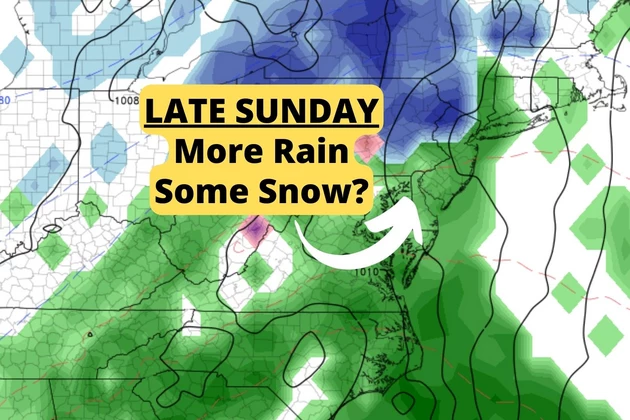
Looming at the end of the weekend — from late Sunday afternoon through early Monday morning — is our next storm system. At the moment, it looks like primarily another rainmaker for New Jersey.
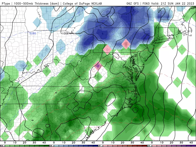
However, I'm really thinking northwestern New Jersey — that's north of I-78 and west of I-287 — will be cold enough for a period of snow or wintry mix into Sunday evening. Maybe even some light accumulations. In fact, one forecast model — the NAM — goes bonkers with accumulating snow across all of inland New Jersey. (For the record, I'm not going there ... yet.) It is a close call. I would keep a close eye on the forecast throughout the weekend, so you know what impacts to expect for Monday morning's commute.

Friday
As the sun comes over the horizon, we are already seeing some breaks of brighter sky. It is going to be a drier and better day than Thursday, that's for sure. But still a few minor issues around.
As one more weak piece of energy zooms north of New Jersey Friday, we could see a few isolated showers spark up. Mainly to the north. (Although I wouldn't rule out a few raindrops anywhere in the state at some point.) Definitely light and brief.
Meanwhile, wind speeds are going to be elevated. Blowing out of the west at 20+ mph. So it might feel brisk and blustery at times.
We are starting the day with temperatures around 40 degrees. (Above freezing — so puddles are liquid, not icy.) Highs should average upper 40s by Friday afternoon. This part of the forecast is fine and dandy.
Friday night, the winds die down as skies continue to clear. Thermometers will bottom out around the freezing mark, in the lower 30s.
Saturday
A quiet, typical January day. Partly sunny skies will meet cool, dry conditions. Highs will be limited to the lower 40s. No weather issues.
(Great "football weather" for the big Giants-Eagles playoff game in Philly Saturday night!)
Sunday
Skies on Sunday will turn pretty cloudy. But most of the daytime hours will be OK. High temperatures are forecast to reach the lower to mid 40s.
The big weather headline for Sunday is the arrival of our next storm system. A broad area of low pressure will drive in precipitation starting around late Sunday afternoon (let's say 4 p.m.) And it will wrap up early Monday morning (around 4 a.m.)
For most of New Jersey, it looks like this system will produce just plain rain again. On the order of an inch of healthy, soaking rainfall.
However, in a subtle change from our recent string of soggy storms, I believe northwestern New Jersey has a shot at some wintry weather here. North of Interstate 78 and west of Interstate 287, for the first few hours at onset, a period of snow or wintry mix seems likely. Maybe even some light accumulations, up to an inch, before flipping to rain.
It is worth noting that the NAM forecast has gone bonkers with colder temperatures and a much snowier scenario for NJ. (1 to 5 inches statewide?!) I am not ready to buy such a wintry solution at this point, since all other guidance points to another mainly wet scene. But this does mean you should watch the forecast evolve throughout the weekend, in case late Sunday into early Monday does indeed trend colder and icier.
Monday
Again, any precipitation should wrap up in the morning. And then skies clear to sunshine quickly.
Monday will be a bright and blustery day. High temperatures will be above normal, in the mid 40s, possibly sliding backwards through the afternoon.
The Extended Forecast
Tuesday will be similar to Saturday, quiet and cool.
And then another storm system on Wednesday. There could be a wintry component to the northwest again, especially if the Euro model is to be believed. GFS solution shows more pervasive warmer air, leaning toward a will be another soggy, stormy mess. I'm not even going to attempt a stab at impacts just yet. Let's see how storm system #1 works out this weekend, before tackling #2.
Dan Zarrow is Chief Meteorologist for Townsquare Media New Jersey. Follow him on Facebook or Twitter for the latest forecast and realtime weather updates.
Check Out the Girl Scout Cookies for 2023
Gallery Credit: photo courtesy of the girl scouts of the jersey shore
Where Are They Now? Looking Back at New York City TV's Most Famous Anchors & Reporters
Gallery Credit: Joe, 94.5 PST
More From New Jersey 101.5 FM


