

Ian impacts for NJ: 3″ rain, 30+ mph gusts, minor tidal flooding
The Bottom Line
Unsurprisingly, this forecast is all about Ian. We have one more calm, dry day in New Jersey before things start turning rainy and windy through early next week.
Much of Florida is windswept and underwater, after powerful Hurricane Ian made landfall on Wednesday. Power outages measured in the millions, and estimated rainfall totals over a foot in several places.
As of this writing (6 a.m. Thursday), Ian has been downgraded to a tropical storm. Maximum sustained winds are down significantly, to 65 mph, as the storm's center of circulation approaches Melbourne, Florida.
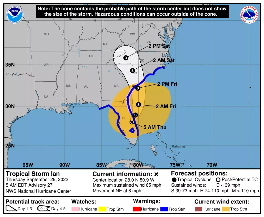
After ejecting into the Atlantic Ocean later Thursday, Ian will make its third landfall around South Carolina on Friday. And then our attention turns to how Ian's remnants will affect New Jersey.
The bottom line: It is going to be inclement and miserable for part of the weekend. Possibly even downright nasty for a time Saturday morning. Some forecasters are suggesting a total washout from Friday through Tuesday — and that's just not the case. It is going to get wet and then windy this weekend. But we will miss the worst of the storm. And there will be breaks of dry weather along the way.

Thursday's Forecast
No weather issues for you, as we enjoy another dry and comfortable fall day. 50s in the morning, mid to upper 60s in the afternoon. That is still a few degrees below normal for late September. Winds will be light. And clouds will increase from south to north. Yup, those clouds are the very northern edge of Ian.
Thursday night also stays quiet. It will be mostly cloudy and cool, with a low temperature around 50.

Ian Timeline
—Friday Afternoon... Showers will start to creep into New Jersey from the south. Although the exact start time of raindrops is hazy, most of NJ (along and north of Interstate 195) could stay dry during Friday's daytime hours.
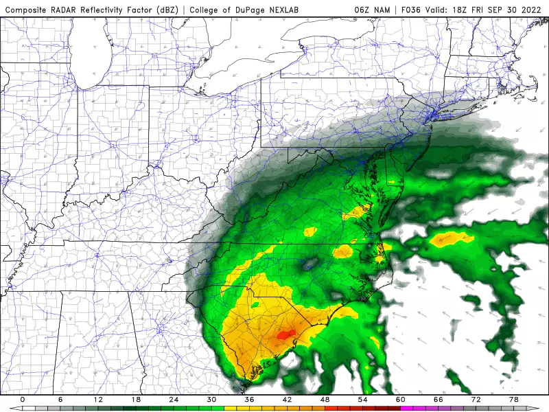
—Friday Evening... Rain continues spreading north into the Garden State. Intensity picks up after about Midnight Friday night.
—Saturday Morning-Midday... Prime time — the period with the heaviest, steadiest rain. Let's say from about 2 a.m. to 2 p.m. Saturday. Rainfall rates may approach an inch per hour, enough to cause big puddles and some flooding issues. It will be a windswept rain too, with gusts in the 20 to 30 mph range.
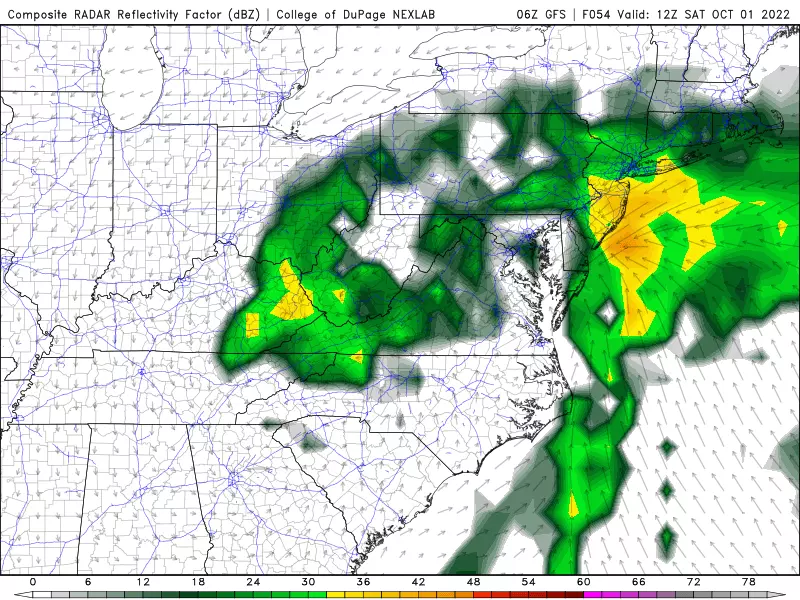
—Saturday Evening... I favor a dry slot arriving by dinnertime Saturday, leading to drier weather through Saturday night. Of course, there could still be some showers around. And, if the wind lightens up enough, possibly areas of thick fog overnight.
—Sunday... Hit or miss. A few waves of spotty to scattered showers will likely sweep through NJ throughout the day. Once again, South Jersey looks wetter than North Jersey.
—Monday & Tuesday... One final piece of Ian energy will be "stuck" just south of New Jersey through early next week. That will keep winds elevated. And we could see a couple more rounds of rain. Maybe even a pocket of heavier stuff. Uncertainty is still fairly high regarding the exact location and spread of these potential thunderstorms.
—Wednesday... New Jersey's next totally dry weather day.
Ian Impacts, By The Numbers
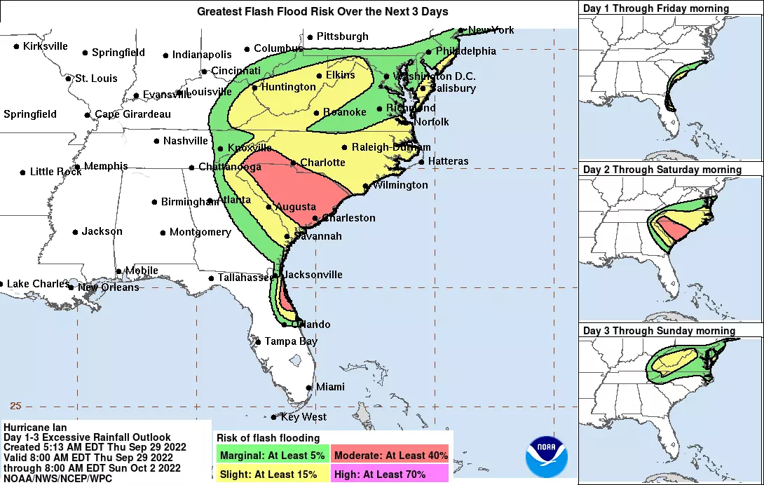
—Rainfall... The heaviest and most prolonged rainfall will be found along southern and coastal New Jersey, on the order of 2 or 3 inches total. Father inland, close to the NJ Turnpike corridor, we'll end up with a healthy inch in the bucket. Northwestern New Jersey, this isn't your storm, with less than a quarter-inch of rain expected.
—Flooding... Whenever multiple inches of rain are in the forecast, we have to ring alarm bells for flash flooding and river flooding. Having said that, New Jersey's rivers, streams, and creeks are all running quite low following this summer's drought conditions. So yes, there could be some "big puddles" and travel troubles around the state through the first half of the weekend.
—Wind Gusts... Ian has already lost a lot of steam. And again, the center of the storm will stay south of NJ. During the heavy rain, gusts may approach 30 mph. And then Sunday-Monday potentially gets even windier, with some northeasterly gusts in the 30 to 40 mph range. (Especially along the coast.) Not incredibly pleasant, and enough to bring down vulnerable tree branches and power lines. But I wouldn't call 40 mph gusts "damaging" per se.

—Tornadoes... The risk for a quick spin-up is low, but not zero. Best chance is probably from any thunderstorms that spawn Monday-Tuesday.
—Storm Surge... This storm is "attacking" us from the land, not the ocean. But as I mentioned, there is a strong northeasterly (on-shore) wind component involved here. That will push some water toward the Jersey Shore. At the very least, rough surf and rip currents will be a problem at the beaches for the duration. And a foot or two of extra tidal rise (storm surge) could lead to several rounds of minor category flooding during high tide this weekend.
The Extended Forecast
By Wednesday, Ian will finally be out of our hair. And on Thursday, a cold front could drive in another brief round of rain, followed by clearing skies.
One thing is very clear in the extended forecast: There is no warmup in sight here. High temperatures will only reach the 60s, at best, for the duration. Noticeably below normal for late September and early October.
Dan Zarrow is Chief Meteorologist for Townsquare Media New Jersey. Follow him on Facebook or Twitter for the latest forecast and realtime weather updates.
What would happen to NJ if we were attacked by nuclear weapons?
Gallery Credit: Eric Scott
Fuhgeddaboudit! Great Jersey names for a hurricane
Gallery Credit: Steve Trevelise
More From New Jersey 101.5 FM


