
Heads up, NJ: Active, stormy weather and a big cooldown Wednesday
The Bottom Line
As a strong cold front races toward New Jersey, Wednesday will be a day of transition. From warm to cold. From unsettled to stormy. Lots to be aware of, so let's dive in.
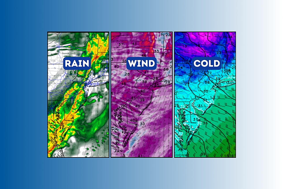
The biggest alarm bell to ring is for wind. Gusts may exceed 40 mph before, during, and after Wednesday evening's thunderstorms. A Wind Advisory has been issued for the entire state, from Wednesday through early Thursday morning.
Thunder and lightning are possible Wednesday evening too.
Rainfall totals may exceed an inch in spots. Flooding is not really a concern, although heavy rain may make for lousy driving conditions.
Even as the temperature drops, the chance of wintry weather will be very limited. There could be some icy spots by Thursday morning, as temperatures plunge below freezing. And a few snow showers and snow squalls are in the forecast for the rest of Thursday.

Wednesday
Wednesday will be another warm day. But not very "pretty" as unsettled, cloudy, wet weather takes hold of the Garden State.
We are starting off Wednesday morning with temperatures in the 50s. Eerily warm. And not feeling like February at all. (These warm temps are quite a bit above our normal high temperatures for this time of year.)
High temperatures will again shoot for the lower 60s. This is easily the warmest stretch of 2024 so far. (A few weather stations hit 69 degrees on Tuesday!)
Pockets of rain will make for occasionally wet weather through both Wednesday morning and afternoon. It is not going to rain all day necessarily, but you will want the umbrella at times.
The day will become increasingly breezy as well.
The nastiest weather of the day will arrive with our impending cold front in the Wednesday early evening hours. Let's say between 5 p.m. to 8 p.m. — dinnertime, give or take. A period of heavy rain and gusty winds is likely, statewide. Thunderstorms are possible during this grand finale push as well.
Storms will calm down by late evening, with raindrops ending completely by Midnight. Then our attention turns to tumbling temperatures and a brisk northwesterly wind overnight.
Low temperatures are forecast to dip into the upper 20s to around 30 degrees. Enough of a freeze to worry about icy spots Thursday morning. (The wind will help to evaporate rain water off some wet surfaces, but not all puddles will be completely gone before the freeze. So watch your step.)
Thursday
Thursday will bring a return of cold, blustery weather. But it is only temporary.
High temperatures on Thursday will only reach the lower 40s. A far cry from the 50s and 60s earlier in the week. A brisk wind will blow up to 30 mph.
So, despite mostly sunny skies, it will be a blustery day. Back to bundling up.
In addition, that wind will likely spark some lake-effect snow from Erie and Ontario. Snow showers or even snow squalls are possible at some point here in the Garden State. I doubt we are looking at any accumulation, but a sudden reduction in visibility due to heavy snowfall could be treacherous.
Friday
The first of March will be a quiet weather day. Skies will progress from sun to clouds, as temperatures moderate. Look for highs around the upper 40s.
Saturday
Our next storm system will be a little impulse riding through New Jersey's atmosphere for the first half of Saturday. Once again, it looks like just a rainmaker — no wintry weather threat. Total rainfall will be on the order of a quarter-inch to half-inch.
Slow clearing will ensue Saturday afternoon, as temperatures barely stay on the mild side of normal. Highs should hit about 50 degrees on Saturday.
Sunday & Beyond
Temperatures will warm into the mid 50s on Sunday. The day has potential, although clouds and patchy drizzle may get in the way of a truly pleasant time.
More 50s and even 60s are ahead for next week, although with unsettled weather. A series of storm systems passing off-shore will produce chances of rain and drizzle, and keep New Jersey's skies mostly cloudy.
Still no wintry weather on the horizon, as the narrow for a "big storm" continues to close. The official start of spring is just 20 days away.
NJ is a top producer of these crops
Gallery Credit: Dino Flammia
Dan Zarrow is Chief Meteorologist for Townsquare Media New Jersey. Follow him on Facebook for the latest forecast and realtime weather updates.
Latest additions to NJ DOT's 2024 collection of humorous safety messages
Gallery Credit: Dan Alexander
More From New Jersey 101.5 FM


