

8 things to know about Monday’s severe storms and flash flooding
Severe Thunderstorm Watch in effect until 8 p.m. for Bergen, Essex, Hudson, Hunterdon, Mercer, Middlesex, Morris, Passaic, Somerset, Sussex, Union and Warren counties.
The very warm and humid air over New Jersey will likely fuel some powerful thunderstorms with torrential rain late Monday.
1.) Heat + Humidity = Thunderstorm Fuel
This weekend featured a mix of weather - scattered sunshine, scattered clouds, scattered showers, and some fog. The one constant was the high humidity, which may have left you diving for the air conditioner switch. That warmth and humidity will help fuel some powerful, loud thunderstorms on Monday. This is one of those forecasts and one of those weather days where you really need to pay attention.
Monday will begin mostly sunny, windy, warm, and very humid. Morning temperatures are in the mid to upper 70s — gross! Meanwhile, widely scattered showers and thunderstorms will be possible for the first half of the day. While these early storms may grow to strong limits, they're just the appetizer.
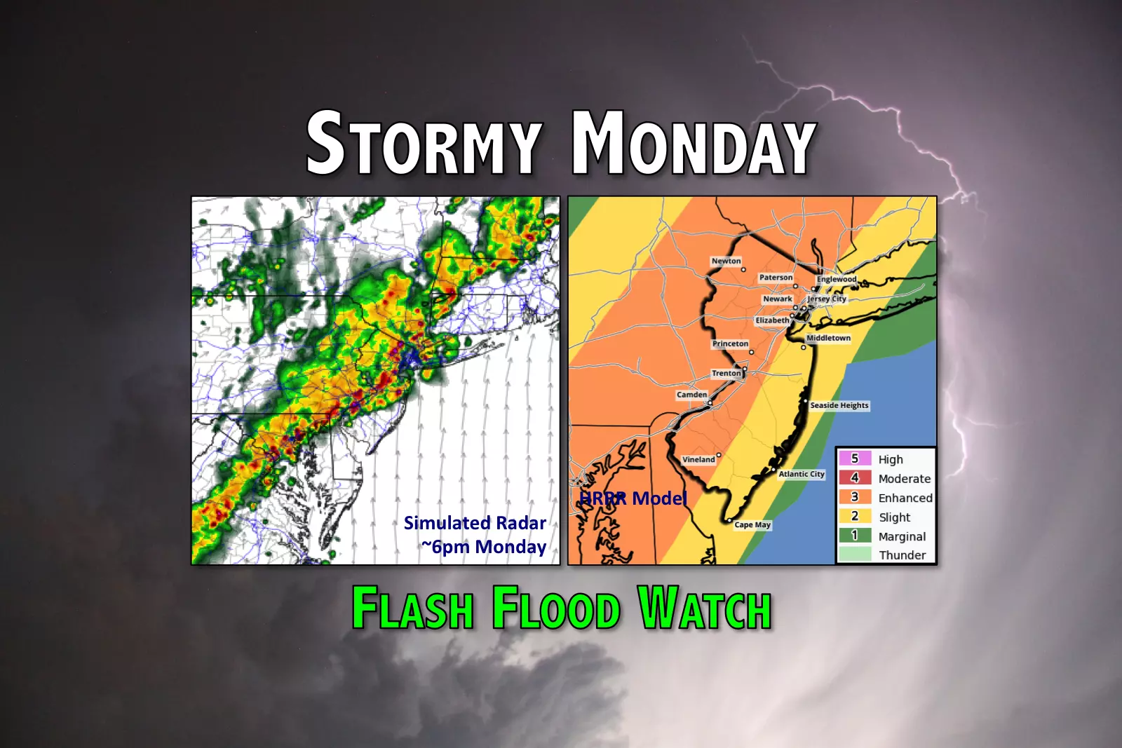
A (weak) cold front will spawn a line of strong to severe thunderstorms, which will begin sweeping through the Garden State Monday afternoon through evening. Everyone in the state will probably see a period of very heavy rain. The strongest storms may produce gusty winds, large hail, and frequent lightning.
2.) Timing
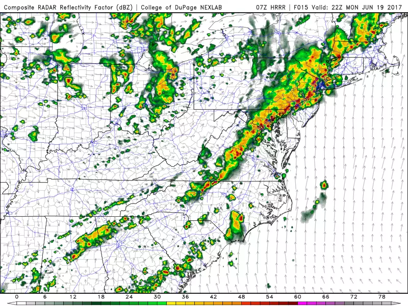
Again, scattered showers and thunderstorms will be possible through Monday morning and early afternoon. We'll really have to start watching the sky around 3 p.m., as the line of strong thunderstorms begins pushing across the Delaware River. Unfortunately, the timing of these ferocious storms will coincide with the evening rush hour.
The threat of severe weather (wind, hail, tornadoes) will pulse down after sunset (about 8:30 p.m.) However, the storms will continue to produce heavy rain. Models suggest the final thunderstorms will exit the coast by around Midnight (give or take).
3.) Rain
The biggest weather concern from these thunderstorms will be torrential downpours, leading to potential flash flooding. Several inches of rain is likely to fall in a very short period of time, inundating storm drains, roadways, and low-lying areas. Widespread 1 to 3 inch rainfall totals are likely, with localized amounts up to 5 inches possible. That is a lot of rain!
4.) Flash Flood Watch

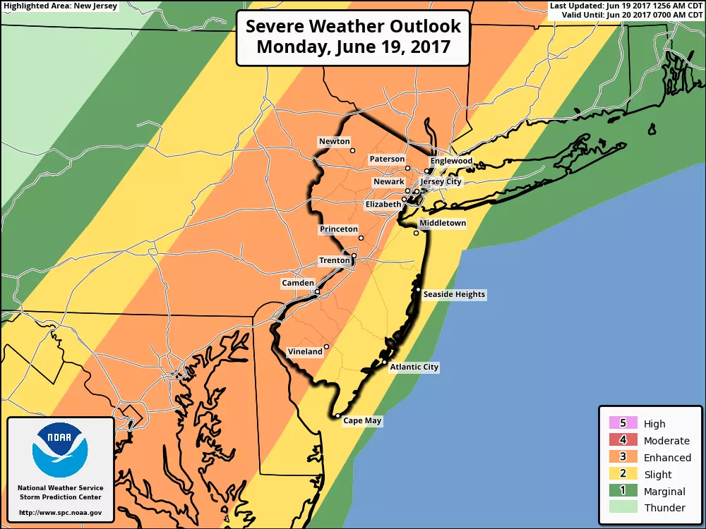
The National Weather Service has issued a Flash Flood Watch for most of New Jersey:
--From Noon to Midnight for NW Burlington, Camden, Gloucester, Hunterdon, Mercer, Middlesex, Monmouth, Morris, Salem, Somerset, Sussex, and Warren counties.
--From Noon to 4 a.m. for Bergen, Essex, Hudson, Passaic, and Union counties.
A watch means torrential downpours could cause abrupt flooding of creeks, streams, roadways, and other poor drainage areas. If a Flash Flood Warning is issued later, it means such flooding is imminent or already occurring.
Additional severe thunderstorm watches and warnings are likely to be issued later Monday as the storms draw closer.
5.) Wind & Hail
Heavy rain does a very efficient job of cooling air as it falls. That cooler air gets pushed ahead of a thunderstorm (outflow) and can become quite strong, and therefore potentially damaging. Wind gusts in excess of 60 mph are possible (if not likely) on Monday.
Hail is formed when a particle of dust gets caught in a strong updraft (upward wind), accumulating ice until it falls from the sky. While we don't see hail often from New Jersey thunderstorms, there is a marginal chance the strongest storms on Monday will produce hail. Anything larger than quarter-sized hail can cause significant damage to cars and houses (and people too).
6.) Tornado
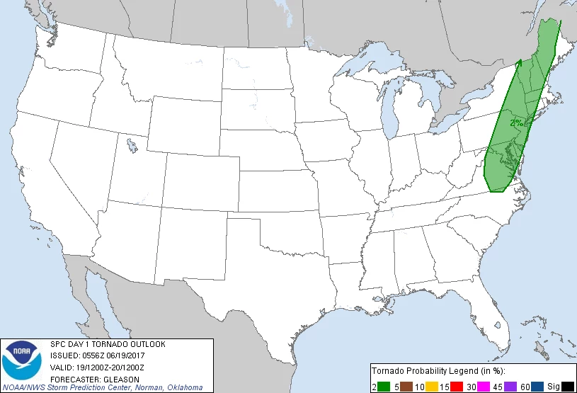
Yes, there is a slight chance for a tornado too. Atmosphere conditions have to be "just right" for a thunderstorm to spawn a tornado, and Monday's severe weather parameters will be close. The big limiting factor will be the "mode" of the storms — a line of thunderstorms (as we're forecasting) is less likely to become tornadic than discrete thunderstorm cells.
While the heavy rain threat will affect the entire state, the overall chance for severe weather will be greatest where temperatures are warmest. I suspect we'll really have to watch the I-295 corridor in SW NJ for the biggest wind, hail, and tornado threat.
7.) Action Steps
Monday will be one of those rare days where you need to actively monitor the weather, as flash flooding and severe weather are likely for much of New Jersey. You should have a way to monitor the weather and warnings as they are issued. And take any warnings issued seriously — the best place to be during a thunderstorm is inside a sturdy building. Never attempt to drive, swim, or walk through flooded areas.
As the strongest storms arrive Monday afternoon, you can count on us to have live updates on-air and online.
8.) Extended Forecast
After the storms end by early Tuesday morning, skies will progressively clear overnight. The new air mass behind the storms and the front is not much cooler than our current air mass. It is, however, much drier. That decrease in humidity will be noticeable, and will lead to much more comfortable conditions (especially at night).
High temperatures are forecast to hover in the 80s through the entire workweek. There's a chance for a leftover shower on Tuesday. We'll see another chance for an isolated shower on Wednesday as another (weak) front passes through. Friday will be the next "mostly wet" day in the forecast, as another period of unsettled weather takes over New Jersey through the last weekend of June.
Dan Zarrow is Chief Meteorologist for Townsquare Media New Jersey. Follow him on Facebook or Twitter for the latest forecast and realtime weather updates.
More From New Jersey 101.5 FM


